- Home
- :
- All Communities
- :
- Industries
- :
- Telecommunications
- :
- Telecommunications Blog
- :
- Rapidly Deploy a Damage Assessment Solution
Rapidly Deploy a Damage Assessment Solution
- Subscribe to RSS Feed
- Mark as New
- Mark as Read
- Bookmark
- Subscribe
- Printer Friendly Page
- Report Inappropriate Content
In times of disaster response, having the ability to rapidly deploy solutions that aid in disaster recovery is essential to reducing further loss of property and lives. Web GIS and the configurable ArcGIS Apps allow organizations to quickly deploy reliable solutions for field data collection, crowdsourcing, situational awareness, reporting, and constituent engagement. Recent hurricanes Harvey and Irma have left varying degrees of damage across the Caribbean and gulf coast, so I thought it would be valuable to share some insight on how to quickly deploy a couple ArcGIS apps for damage assessment.
Ninja Pro Tip: Esri Disaster Response Program Resources
The two ArcGIS Apps we will focus on are Survey123, and Web AppBuilder. Survey123 is a form-centric web and native mobile app for collecting data with a map location. Web AppBuilder is a JavaScript/HTML5 web app building application that allows for configuring new web apps without coding. So lets get into the steps for setting up a quick damage assessment solution.
Ninja Pro Tip: https://community.esri.com/groups/survey123/blog/2017/06/02/10-facts-you-may-not-know-about-the-surv...
1. Set Up Damage Assessment Groups in ArcGIS Online or Enterprise
- The first thing you'll need to do is create two new groups within your ArcGIS Online or Enterprise portal. Create a Damage Assessment and Damage Assessment Reporting group.

2. Configure Survey
- Then you'll need to configure the damage assessment survey that will be used within Survey123. This can be completed using the new Web Designer or using Survey123 Connect once you have logged into Survey123 (https://survey123.arcgis.com) using your ArcGIS Account.

- For this damage assessment survey example we will use Survey123 Connect that allows you to design your survey in Excel and automatically generate your survey. Below is a short video that walks through Survey123 Connect and how to build your damage assessment survey.
- Once the survey is complete, publish the survey to your ArcGIS account.
Ninja Pro Tip: https://community.esri.com/groups/survey123/blog/2015/09/04/survey123-collector-and-geoform-a-quick-...
3. Configure Reporting Dashboard
- Now you will create a web based dashboard app to view all the damage assessment reports being collected. When you publish the Survey123 damage assessment survey, a new feature service will be created within your ArcGIS portal, so add that layer to a new web map by searching for the layer and adding it to the map.

- Then change the symbology of the layer to match your preference, and configure the layer's pop-up.


- Finally, Save the web map, click on Share > Create Web App, then select the Web AppBuilder tab to open the map in Web AppBuilder.

- Now configure the web app based on your organization's preferences. Below are a few recommended widgets to include in the app.
- Dashboard Theme
- The Dashboard Theme is a new styling theme in Web AppBuilder and will allow you to create a dashboard application with multiple widgets open at once.
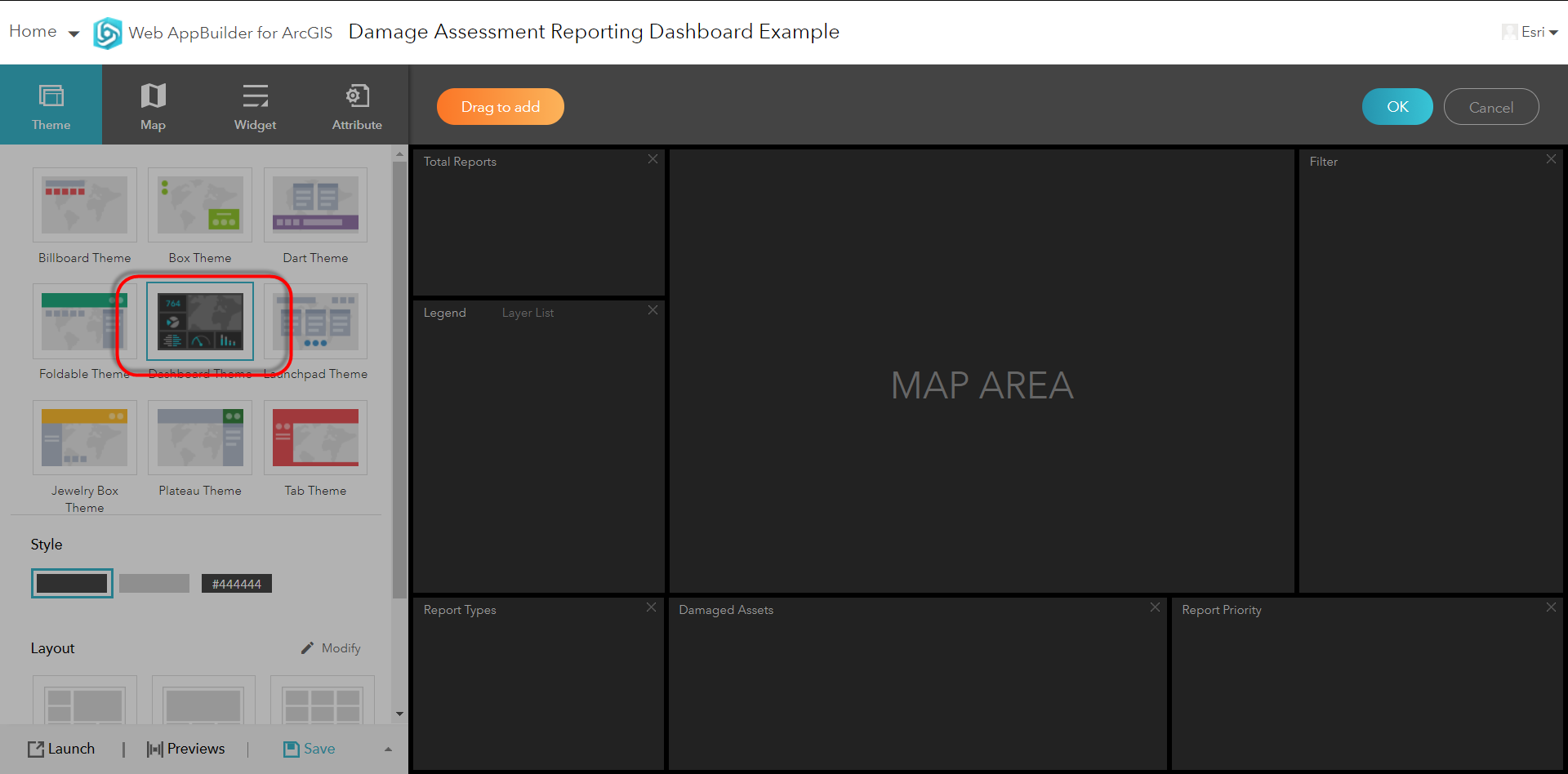
- The Dashboard Theme is a new styling theme in Web AppBuilder and will allow you to create a dashboard application with multiple widgets open at once.
- Infographic Widget
- The Infographic widget will allow you to create charts and graphs within your dashboard themed Web AppBuilder app. Create these inforgraphics to look at status, severity, report type, etc.

- The Infographic widget will allow you to create charts and graphs within your dashboard themed Web AppBuilder app. Create these inforgraphics to look at status, severity, report type, etc.
- Filter Widget
- The filter widget will allow you to filter the damage assessment reports based on an attribute field. So you can filter based on severity, date collected, or any other field in your survey. Setting a filter will also update the infographics in the dashboard.

- The filter widget will allow you to filter the damage assessment reports based on an attribute field. So you can filter based on severity, date collected, or any other field in your survey. Setting a filter will also update the infographics in the dashboard.
- Attribute Table Widget
- The Attribute Table widget will give you a table view of all the data being collected and can be filtered based on the map view or using the Filter widget. You can also export the data to CSV from the attribute table.

- The Attribute Table widget will give you a table view of all the data being collected and can be filtered based on the map view or using the Filter widget. You can also export the data to CSV from the attribute table.
- Smart Editor Widget
- The Smart Editor widget will allow users to update the information collected in the damage assessment. So management or team leads can update the status of a report or close it out.

- The Smart Editor widget will allow users to update the information collected in the damage assessment. So management or team leads can update the status of a report or close it out.
- Dashboard Theme
- The dashboard app built in Web AppBuilder can be configured with over 40 different types of widgets or capabilities, and is responsive to the screen size of the device the user is accessing the app from.

Ninja Pro Tip: What’s New in Web AppBuilder for ArcGIS (September 2017)
4. Share Dashboard and Survey to Damage Assessment Groups
- Share the Web AppBuilder dashboard, the damage assessment Web Map, and the damage assessment layer with the Damage Assessment Reporting group in your portal.
- Share the damage assessment Survey123 survey and the damage assessment layer with the Damage Assessment group.
5. Provision Users into Groups for Access to Apps
- Finally, add users from your ArcGIS Online or Enterprise account to the appropriate groups to give them access to the app they need, whether they are a field person collecting damage assessment, a back office person viewing the reports in a dashboard, or both. The newly shared damage assessment survey can be downloaded by your users from within the Survey123 app, and the dashboard can be viewed from a web browser.
Damage Assessment with ArcGIS

If you are in need of assistance setting up any of these applications or any other solutions during an emergency or disaster, please feel free to reach out to Esri's Disaster Response Program for assistance.
Patrick Huls
Technical Evangelist - The specified space was not found. Survey123 for ArcGIS
LinkedIn: Patrick Huls| Twitter: @SpatialNinja| GeoNet:Phuls-esristaff
You must be a registered user to add a comment. If you've already registered, sign in. Otherwise, register and sign in.