- Home
- :
- All Communities
- :
- Industries
- :
- Education
- :
- Education Blog
- :
- Examining Mapillary Views in ArcGIS Online
Examining Mapillary Views in ArcGIS Online
- Subscribe to RSS Feed
- Mark as New
- Mark as Read
- Bookmark
- Subscribe
- Printer Friendly Page
- Report Inappropriate Content
As I wrote about a year ago, Mapillary is a tool that allows anyone to create their own street level photographs, map them, and share them via web GIS technology. The idea behind Mapillary is a simple but powerful one: Take photos of a place of interest as you walk along using the Mapillary mobile app and upload photos along the way. They will be combined into a street level photo view. Then, explore your places and those from thousands of other users around the world. Mapillary is part of the rapidly growing crowdsourcing citizen science movement, which seeks to generate “volunteered geographic information” content from ordinary citizens. Mapillary is therefore more than a set of tools–it is a community, with its own MeetUps and ambassadors, and it is an Esri partner. I encourage educators to use Mapillary to generate field trip data with your students.
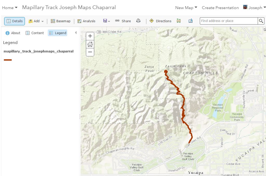
Recently, I wanted to extend what I have been doing with Mapillary. I went for a hike in the chaparral biome in California and recorded my hike that resulted in over 700 images and a track that anyone now can use to take this hike "virtually", with the ability to see to the right, left, straight ahead, and sometimes, behind me as I saw it on that beautiful winter's day.

I wanted to bring my Mapillary track into ArcGIS Online, so I could easily work with it in a variety of ways and in combination with other maps and tools in ArcGIS Online. To do this, first, I zoomed in to the area on the Mapillary website's map that contained my own Mapillary track. Then, I filtered on just my username in Mapillary so I would not download other people's tracks. Then, I clicked "Download Data" under the Advanced Options in Photo Settings to download the GPS track as a GeoJSON file. I then used the Add button in a new map in ArcGIS Online and my Mapillary track is now in that platform, visible here and shown below. Now I can use it just like any other layer in ArcGIS Online!
Other people are doing innovative things in ArcGIS Online with Mapillary tracks and photographs. For example, this story map shows 7 remote places explored by the Mapillary community, including Tonga, Antarctica, and Svalbard, Norway, and this story map shows crowdsourced photos taken at a selected number of US National Parks. The intriguing thing about each of these is that just as you can navigate in Google Street View or on Mapillary across the landscape using the photographs, you can do the same thing with these story maps. In other words, the photos are not "static."
Give Mapillary with ArcGIS a try!
You must be a registered user to add a comment. If you've already registered, sign in. Otherwise, register and sign in.
-
Administration
38 -
Announcements
44 -
Career & Tech Ed
1 -
Curriculum-Learning Resources
178 -
Education Facilities
24 -
Events
47 -
GeoInquiries
1 -
Higher Education
518 -
Informal Education
265 -
Licensing Best Practices
46 -
National Geographic MapMaker
10 -
Pedagogy and Education Theory
187 -
Schools (K - 12)
282 -
Schools (K-12)
184 -
Spatial data
24 -
STEM
3 -
Students - Higher Education
231 -
Students - K-12 Schools
85 -
Success Stories
22 -
TeacherDesk
1 -
Tech Tips
83
- « Previous
- Next »