New and Improved Landsat Apps
- Subscribe to RSS Feed
- Mark as New
- Mark as Read
- Bookmark
- Subscribe
- Printer Friendly Page
- Report Inappropriate Content
A new landing page now exists for apps that allow for the exploration of Landsat remotely sensed data that your students could use to examine geology, urban growth, water and water quality, and more, called "Unlock Earth's Secrets:"
http://www.esri.com/landing-pages/software/landsat/unlock-earths-secrets
This page includes a description of the Landsat on AWS app that that was improved last year:
http://landsatappv1p3.s3-website-us-west-2.amazonaws.com/
This web application highlights some of the capabilities for accessing Landsat imagery layers, powered by ArcGIS for Server, accessing Landsat Public Datasets running on the Amazon Web Services Cloud. The layers are updated with new Landsat images on a daily basis. Quick access to the following band combinations and indices is provided:
- Agriculture: Highlights agriculture in bright green. Bands 6,5,2
- Natural Color: Sharpened with 15m panchromatic band. Bands 4,3,2+8
- Color Infrared: Healthy vegetation is bright red. Bands 5,4,3
- SWIR (Short Wave Infrared): Highlights rock formations. Bands 7,6,4
- Geology: Highlights geologic features. Bands 7,4,2
- Bathymetric: Highlights underwater features. Bands 4,3,1
- Panchromatic: Panchromatic image at 15m. Band 8
- Vegetation Index: Normalized Difference Vegetation Index (NDVI). (Band5-Band4)/(Band5+Band4)
- Moisture Index: Normalized Difference Moisture Index (NDMI). (Band5-Band6)/(Band5+Band6)
The Time tool enables access to a temporal time slider and a temporal profile of different indices for a selected point. The Time tool is only accessible at larger zoom scales. It provides temporal profiles for NDVI (Normalized Difference Vegetation Index), NDMI (Normalized Difference Moisture Index) and an Urban Index. The Identify tool enables access to information on the images, and can also provide a spectral profile for a selected point. The Bookmark tool will direct you to pre-selected interesting locations. This is an extremely helpful and easy-to-use tool for education and research, and runs in a web browser!
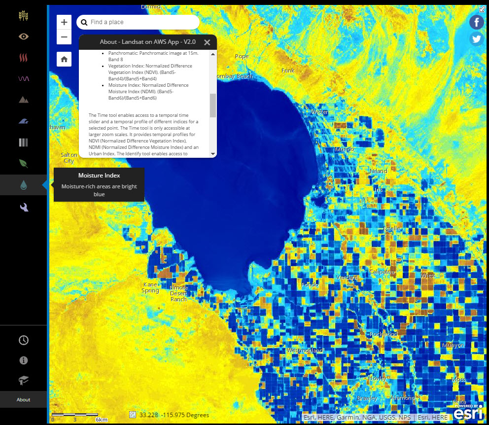
Landsat AWS Amazon Web Services app showing moisture index near the Salton Sea in California.
I reviewed the above app on the Spatial Reserves data blog:
The new landing page also includes a new app called Landsat Explorer :
http://landsatexplorer.esri.com/
This app allows you to change the colors by which the images are rendered. It also allows you to pick dates and compare imagery across time, swipe to compare two dates, set up masks to cover or highlight, compute the change between two dates, identify a scene or point, and see sample stories from around the world using the same imagery. One of the most powerful features, though, is its connections to ArcGIS Online. It has the ability to save the top layer to ArcGIS Online, and also add data from ArcGIS Online.

Landsat Explorer App showing images from two different dates near Bakersfield, California.
You must be a registered user to add a comment. If you've already registered, sign in. Otherwise, register and sign in.
Examine the Earth with New and Improved Landsat Apps
-
Administration
38 -
Announcements
45 -
Career & Tech Ed
1 -
Curriculum-Learning Resources
179 -
Education Facilities
24 -
Events
47 -
GeoInquiries
1 -
Higher Education
519 -
Informal Education
266 -
Licensing Best Practices
46 -
National Geographic MapMaker
17 -
Pedagogy and Education Theory
187 -
Schools (K - 12)
282 -
Schools (K-12)
185 -
Spatial data
24 -
STEM
3 -
Students - Higher Education
231 -
Students - K-12 Schools
86 -
Success Stories
22 -
TeacherDesk
1 -
Tech Tips
83
- « Previous
- Next »