- Home
- :
- All Communities
- :
- Industries
- :
- Public Safety
- :
- Public Safety Blog
- :
- Mohegan Tribe Prepares for Next Generation 9-1-1 a...
Mohegan Tribe Prepares for Next Generation 9-1-1 and Indoor Routing
- Subscribe to RSS Feed
- Mark as New
- Mark as Read
- Bookmark
- Subscribe
- Printer Friendly Page
- Report Inappropriate Content
By Mike King, Global Emergency Call Taking Industry Manager, Esri
In 2012, the Mohegan Tribe of Indians of Connecticut launched an impressive GIS project with the goal of building an enterprise-wide system of land, infrastructure, and facility information. This effort—spearheaded by the tribe's CAD/GIS Document Control Department—was in response to the need to better manage assets, use of space, and occupancy on the Mohegan Tribe's reservation. However, the project also provided an opportunity to improve the integrity of the existing 911 database and answer the clarion call from emergency call taking organizations and the Federal Communications Commission regarding Next Generation 9-1-1 (NG9-1-1).
The challenge? Bring tribal property up to NG911 standards and prepare for emergency indoor routing.
At the heart of the Mohegan reservation are the Mohegan Tribal Government and Community Center, a day care center, a retirement facility, a public safety complex, Fort Shantok (a public park), the Mohegan Church, and 129 multi-and single-family residential units. Also on the reservation stands Mohegan Sun, with a two-tower, 1,600-room luxury hotel and a world-class casino facility. Located on the Thames River in Uncasville, the casino boasts 300,000 square feet of gaming excitement; a 20,000-square-foot spa; and more than 40 restaurants, bars, and lounges. With all that plus its impressive 130,000 square feet of retail shops, a 10,000-seat arena, 7,000 employees, and hundreds of thousands of visitors each year, Mohegan Sun itself resembles a small community.
To help solve their problem, tribal officials turned to the CAD/GIS Document Control Department including Steven Marien, department director, and Andrew Bowne, GIS administrator.

About two years ago, Bowne came to the tribe, bringing two decades of experience in designing, implementing, and managing enterprise GIS. Marien, geographic information officer (GIO) for the tribe and a licensed land surveyor, certified federal surveyor, and 30-year-veteran CAD and GIS manager, founded the tribe's growing enterprise GIS program in 2012. Together, these professionals are working with key stakeholders in Mohegan tribal government—including public safety, information systems, and human resources (HR) staff—to undertake a massive space use and occupancy data collection effort. To do this, the team is leveraging Amazon Web Services, the ArcGIS platform, and web applications. Also, the team is using consulting services from Esri partner PenBay Solutions for initial data collection and to establish an efficient long-term data management program. Bowne uses his extensive database and expertise to enable data exports that streamline updates to the 9-1-1 database.

Mohegan relies on (Lucent Technologies) Palladium system for E-911 and is preparing for an NG9-1-1 upgrade in late 2016. The E-911 system is not integrated with the dispatch solution eFORCE from IntelliChoice Systems, but enhancements are expected by the close of 2016.
To build an interior map of the facility, Bowne and Marien worked with PenBay to develop a number of models that integrated and configured the room and occupant information for employee offices, hotel rooms, etc. Using ArcGIS and the tools provided through PenBay's InVision solution, the necessary data was accessed and integrated into the newly created floor plans. In the end, employee information was integrated with the geographic data for a comprehensive facility floor plan that provided overall location information on personnel, assets, and equipment. PenBay's web applications provide public safety and facility managers with the ability to access interactive digital exterior and interior maps of the facility, including nearby critical infrastructure, and to find specific target areas by using simple, intuitive queries and search tools.

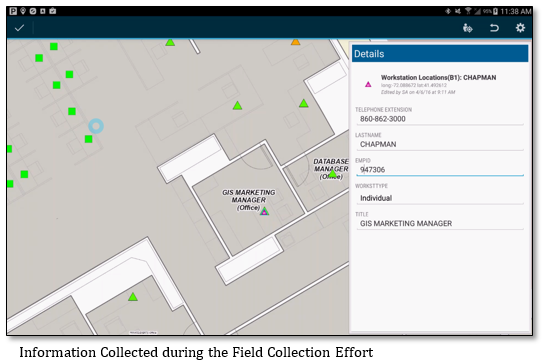
Because employees' workstations are constantly being moved within and across the facilities, the tribe utilized ArcGIS to update the NG9-1-1 database, providing quick and easy access to human and physical asset locations on a map.
Using Esri's Collector for ArcGIS, employees embarked on a data collection effort throughout the facilities. The effort included collecting a point at the location of each employee's assigned workstation, floor by floor. This data was joined with records that displayed the office location, employee name, department, job title, and contact information.

Additionally, the locations of all shared, conference, and courtesy phones (including extensions) were collected and displayed.

Finally, a series of spatial views were created to show employees' locations with corresponding addresses, and operational dashboards were configured with Esri templates. Web maps were created using Web AppBuilder for ArcGIS.
As the project matures, the data will be exported into other technologies and linked to national databases, NG9-1-1 systems, and partner agencies.
The Mohegan Tribe project is a great example of ways in which organizations can prepare for NG9-1-1 while taking advantage of the results immediately.
You must be a registered user to add a comment. If you've already registered, sign in. Otherwise, register and sign in.