- Home
- :
- All Communities
- :
- User Groups
- :
- Coordinate Reference Systems
- :
- Blog
- :
- Global Geodetic Reference Frame (GGRF)
Global Geodetic Reference Frame (GGRF)
- Subscribe to RSS Feed
- Mark as New
- Mark as Read
- Bookmark
- Subscribe
- Printer Friendly Page
- Report Inappropriate Content
Introduction
The Global Geodetic Reference Frame (GGRF) is the realisation of the Global Geodetic Reference System (GGRS). The GGRS comprises terrestrial and celestial components allowing users to precisely determine and express locations on the Earth, as well as to quantify changes of the Earth system in space and time.
What is the GGRF?
GGRF has been developed to support the increasing demand for positioning, navigation, timing, mapping, and geoscience applications. It is an essential development for a reliable determination of monitoring changes in the Earth system, natural disaster management, sea-level rise and climate change amongst many other things. The GGRF has also come about due to globalization and the need for universal interoperability requirements across geospatial technologies.
The economic benefit of implementing the Global Geodetic Reference Frame is significant and it will play a big role in underpinning the UN's Sustainable Development Agenda.
GGRF Theory
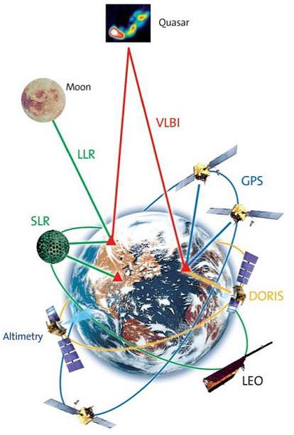
At present, the GGRF is realized through the International Terrestrial Reference Frame (ITRF), International Celestial Reference Frame (ICRF) and physical height systems including the future International Height Reference Frame (IHRF), and the new global absolute gravity network (IGSNn). In other words an integrated global geodetic reference frame.
The infrastructure for the realisation of the GGRF has been published by the Global Geodetic Observing System (GGOS) a part of the International Association of Geodesy and includes the integration of multiple geodetic observation bases. GGOS has defined the GGRF to include many layers of observation including terrestrial networks with geometric and gravimetric observation stations, artificial satellites, the moon and the planets, and extragalactic objects". These infrastructures include the geometry and gravity field of the Earth and the Earth's orientation with respect to the celestial reference frame.
Implementation
The GGRF is an integrated geodetic reference frame, meaning the combination of many reference frames, terrestrial, celestial, height and gravity networks. With the large amount of collaboration and integration needed to reach a GGRF the UN published a resolution on a Global Geodetic Reference Frame for Sustainable Development.
This resolution calls for the international community to encourage and work together, through international organisations including the IAG, to build a global community opening sharing geodetic data, standards and governance as well as providing technical assistance and development in geodesy across developing countries.
I think that is something we can all get behind and hope to see develop in the coming years!
References
You must be a registered user to add a comment. If you've already registered, sign in. Otherwise, register and sign in.