- Home
- :
- All Communities
- :
- Industries
- :
- Transportation
- :
- Roads and Highways
- :
- Roads and Highways Blog
- :
- The ArcGIS Online Czar
The ArcGIS Online Czar
- Subscribe to RSS Feed
- Mark as New
- Mark as Read
- Bookmark
- Subscribe
- Printer Friendly Page
- Report Inappropriate Content
In 2002 I heard for the first time that 90% of GIS is data. Being an undergraduate at the time I had no context for this statement. After 15 years I find it to be very true. Hidden within every organization using GIS is a gathering of data - temporary files, files from projects started and not finished, clips, snapshots, draft versions, map files, spreadsheets, shapefiles, personal geodatabases… you get the idea. These data are located on desktops, on file servers, tucked within our database servers, some hidden recess. The information is organized by the unique, but structured mind of the individual GIS professional displaying the characteristics common to our profession. The larger the organization and the more GIS professionals, the greater number of hiding places and filing schemes. Standardization? Pfah! Why waste the time? Storage is inexpensive. A process for cleaning up unnecessary files and keeping only valuable content? Phooey! Onward! To the next project!
The same basic story can be applied to the end products we create - datasets, reports, maps, apps, etc.. We GIS professionals apply every flavor of database, database design, format, and symbology. And, we’re likely to argue over the rightness of our choices. Little thought is applied to collective customers of the organization as we produce material for our individual customers. Setting standards or guidelines is difficult to think through, much less enforce. It becomes exponentially more difficult the greater the physical distance between GIS professionals and the further separated those professionals are within an organizational structure. For those of us that see the need, application of good governance of any flavor usually takes executive/high-level management support. And, let’s face it, GIS is still highly misunderstood among the larger IT community much less within executive management circles. Receiving the level of support necessary to establish and enforce good governance within any organization not solely GIS focused is a daydream.
And then comes ArcGIS Online.
An ArcGIS Online organization account is centrally administered. One person can see all content. One person can see all users. There are readily available metrics on how the account is being used. There is the possibility to establish a process that can be applied to all users and can be enforced by a single person. And, that person does not have to be a system engineer or database administrator. Really?! Yes. This person can be anyone.
Who then should this person be?
I worked on this thought for months. With help from some great people at Esri (Keith King, Seth Van Aken , Matthew Kabak, and Jim McAbee) I fleshed it out. This person should be a balance of marketing, administration, and traditional GIS. This person should be capable of seeing the ArcGIS Online account as a whole; be able to think through and apply organization schemes; be able to apply branding concepts to the ArcGIS Online environment; and, be able to sit down with someone with little to no GIS experience and show them how to operate within ArcGIS Online. Keith King jokingly referred to this person as the ArcGIS Online Czar. They exist.
In the months since hiring our own, Brian Kingery, we have made tremendous progress. Our GIS team has embraced the notion and sees the benefits. Other GIS professionals in organizations outside our own are seeing the resulting products and using them, growing them. That brings up another important point. It is easy to collaborate between ArcGIS Online organizations. If your organization has made content public others can see it, copy the ideas, and make it better. That is largely what this position does; focus on the ArcGIS Online environment, improving how we operate in that environment. Thanks to some additional Esri input via Michael Zugelder we have been able to get grips on our past use and usership. We now have an operational scheme that is articulated in a series of implementation guides and help documents.
ArcGIS Online @ VDOT Help Documents
In viewing these story maps you will see the ArcGIS Online content item branding scheme we have applied.
Additionally, our team member Michele Mandell began producing our monthly user community newsletter using publicly shared cascading story maps.
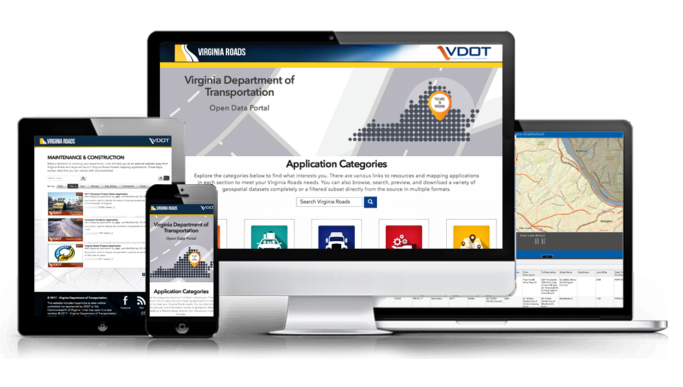
And, as a culmination of everything our ArcGIS Online Administrator has applied to date, we recently released Virginia Roads as an Open Data 2.0 site. Within this site you will see our branding scheme applied throughout, including within the published webapps.
We still have lots of work to do. I fully believe having an ArcGIS Online Administrator to be necessary, and even a primary need for our and any [Arc]GIS staff. I hope to see the propagation of this idea and the resulting storm of creativity and excellence it could foment.
You must be a registered user to add a comment. If you've already registered, sign in. Otherwise, register and sign in.