- Home
- :
- All Communities
- :
- User Groups
- :
- New Zealand GIS for Emergency Management Community
- :
- Blog
- :
- NZGIS4EM June 2017 Update
NZGIS4EM June 2017 Update
- Subscribe to RSS Feed
- Mark as New
- Mark as Read
- Bookmark
- Subscribe
- Printer Friendly Page
- Report Inappropriate Content
This week there were updates to both ArcGIS Online and ArcGIS Pro 2.0 was released. This is a short blog post to highlight what is relevant for emergency management in New Zealand.
1) The Solutions for Emergency Management have also been updated (What's New | ArcGIS for Emergency Management).
- This includes updated symbology in the Service Catalog (simpler, easier to read symbols).
- A series of enhancements to Situational Awareness Viewer, Logistics Planning, and Operations Response.
- A series of enhancements to the ArcGIS Solutions Deployment Tool.

2) Web AppBuilder Widgets (What’s New in Web AppBuilder for ArcGIS (June 2017) | ArcGIS Blog )
- Full Screen Widget – This enables web apps to launch in full screen mode in your web browser.
- Grid Overlay Widget - For those of you working with NZ Defence Force and Urban Search and Rescue in the US, this is a great addition. This will render and display a US Military Grid Reference System (MGRS) grid dynamically and at different index levels inside the application based on the scale of the map display.
- Screening widget – Enables you to define an area of interest (based on a placename and buffer distance; drawing a point, line, or polygon; an input shapefile that defines the spatial extent; or a coordinate location and buffer distance) and analyze specified layers for potential impacts. The analysis results can be shared with others as a printed report, CSV file, and file geodatabase or shapefile download. Below I have configured this widget to work with a Situation Report feature layer template.
See the PDF report produced here.

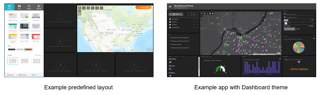
3) Web AppBuilder Dashboard Theme (Theme—Web AppBuilder for ArcGIS | ArcGIS)
The new theme displays all the widgets in the panel simultaneously when the app starts. It is designed to visualize widgets and their communication directly. You can modify the predefined layout by adding, removing, or resizing the grids in the panel. By default, most on-screen widgets are turned off except for the Home and Zoom Slider widgets. Optionally, you can turn on the Header widget to display the logo, the app name, and links.
You must be a registered user to add a comment. If you've already registered, sign in. Otherwise, register and sign in.