Turn on suggestions
Auto-suggest helps you quickly narrow down your search results by suggesting possible matches as you type.
Cancel
- Home
- :
- All Communities
- :
- Industries
- :
- Water Resources
- :
- Water Resources Questions
- :
- GeoRAS 10.1 - Fails to import RAS data
Options
- Subscribe to RSS Feed
- Mark Topic as New
- Mark Topic as Read
- Float this Topic for Current User
- Bookmark
- Subscribe
- Mute
- Printer Friendly Page
GeoRAS 10.1 - Fails to import RAS data
Subscribe
9295
11
08-27-2013 09:01 AM
08-27-2013
09:01 AM
- Mark as New
- Bookmark
- Subscribe
- Mute
- Subscribe to RSS Feed
- Permalink
- Report Inappropriate Content
Hello!
I am using ArcMap 10.1 and HEC-GeoRAS 10.1.
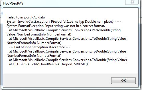
I am having problems using GeoRAS to import HECRAS water levels back into ArcMAP to create maps for inundated areas. When following the procedure in the GeoRAS-tutorial, the step "Import RAS Data" fails and I get this error message:
[ATTACH=CONFIG]27022[/ATTACH]
I have seen some earlier postings on this (and similar) topics, but none that really provides a solution. At the same time I know of several colleagues that have experienced this problem, and not been able to solve it. Instead they have given up, and reinstalled older versions of ArcMap and GeoRAS.
Is there really a flaw in GeoRAS 10.1 such that the import functionality does not work in version 10.1? I believe this is not so, but I would surely appreciate it if someone could advice me on how to overcome this problem.
I have tried using both TINs and DEMs as terrain-files. The error also occurs when using the Baxter example dataset from HEC-GeoRAS download site.
Thank you in advance!
maladuk
I am using ArcMap 10.1 and HEC-GeoRAS 10.1.
I am having problems using GeoRAS to import HECRAS water levels back into ArcMAP to create maps for inundated areas. When following the procedure in the GeoRAS-tutorial, the step "Import RAS Data" fails and I get this error message:
[ATTACH=CONFIG]27022[/ATTACH]
I have seen some earlier postings on this (and similar) topics, but none that really provides a solution. At the same time I know of several colleagues that have experienced this problem, and not been able to solve it. Instead they have given up, and reinstalled older versions of ArcMap and GeoRAS.
Is there really a flaw in GeoRAS 10.1 such that the import functionality does not work in version 10.1? I believe this is not so, but I would surely appreciate it if someone could advice me on how to overcome this problem.
I have tried using both TINs and DEMs as terrain-files. The error also occurs when using the Baxter example dataset from HEC-GeoRAS download site.
Thank you in advance!
maladuk
11 Replies
09-16-2013
03:57 PM
- Mark as New
- Bookmark
- Subscribe
- Mute
- Subscribe to RSS Feed
- Permalink
- Report Inappropriate Content
Please send me the sdf file.
Amit Sinha
Esri
Amit Sinha
Esri
01-16-2014
11:11 PM
- Mark as New
- Bookmark
- Subscribe
- Mute
- Subscribe to RSS Feed
- Permalink
- Report Inappropriate Content
please, tell me how to solve the issue of the problem with program, because I have the same problem as others.
01-17-2014
07:52 AM
- Mark as New
- Bookmark
- Subscribe
- Mute
- Subscribe to RSS Feed
- Permalink
- Report Inappropriate Content
Does the geodatabase have a raster dataset within it?
This can trip it.
Another option could be to try it with the HEC supplied dataset, and compare your dataset.
This can trip it.
Another option could be to try it with the HEC supplied dataset, and compare your dataset.
02-18-2014
09:51 AM
- Mark as New
- Bookmark
- Subscribe
- Mute
- Subscribe to RSS Feed
- Permalink
- Report Inappropriate Content
Hey all!
I have exactly the same problem! I am always getting this error message when I am working with GeoRAS to import HECRAS water levels back into ArcMAP to create maps for inundated areas. I have tried everything - I checked if in my computer settings there is set a separator "." insteda of ",", I have tried to use another coordinate system but I am always getting this error message. I am using ArcMap 10.1, HEC-RAS 4.1.0.
Any advice, please? :((((
[ATTACH=CONFIG]31560[/ATTACH]
02-18-2014
11:34 AM
- Mark as New
- Bookmark
- Subscribe
- Mute
- Subscribe to RSS Feed
- Permalink
- Report Inappropriate Content
Can you post your RAS exported SDF file?
02-18-2014
12:00 PM
- Mark as New
- Bookmark
- Subscribe
- Mute
- Subscribe to RSS Feed
- Permalink
- Report Inappropriate Content
02-20-2014
05:58 AM
- Mark as New
- Bookmark
- Subscribe
- Mute
- Subscribe to RSS Feed
- Permalink
- Report Inappropriate Content
Is it possible that the problem is causing the negative numbers in my local coordinate systém? I still haven´t found the solution 😞
02-26-2014
06:13 AM
- Mark as New
- Bookmark
- Subscribe
- Mute
- Subscribe to RSS Feed
- Permalink
- Report Inappropriate Content
So here is the solution!
after you get the SDF file from HEC-RAS use the xml converter in HEC-GeoRAS and produce the xml file. Then open the xml file in the text editor and on the line with spatial extent delete all the numbers behind the decimal point including the decimal point. Save the changes and follow the next steps in importing the inundation layer. It works.
after you get the SDF file from HEC-RAS use the xml converter in HEC-GeoRAS and produce the xml file. Then open the xml file in the text editor and on the line with spatial extent delete all the numbers behind the decimal point including the decimal point. Save the changes and follow the next steps in importing the inundation layer. It works.
04-15-2014
08:20 AM
- Mark as New
- Bookmark
- Subscribe
- Mute
- Subscribe to RSS Feed
- Permalink
- Report Inappropriate Content