Turn on suggestions
Auto-suggest helps you quickly narrow down your search results by suggesting possible matches as you type.
Cancel
- Home
- :
- All Communities
- :
- Products
- :
- ArcGIS GeoStatistical Analyst
- :
- ArcGIS GeoStatistical Analyst Questions
- :
- Interpolation with Barrier
Options
- Subscribe to RSS Feed
- Mark Topic as New
- Mark Topic as Read
- Float this Topic for Current User
- Bookmark
- Subscribe
- Mute
- Printer Friendly Page
Interpolation with Barrier
Subscribe
5118
13
02-12-2014 07:35 AM
02-12-2014
07:35 AM
- Mark as New
- Bookmark
- Subscribe
- Mute
- Subscribe to RSS Feed
- Permalink
- Report Inappropriate Content
[ATTACH=CONFIG]31354[/ATTACH]
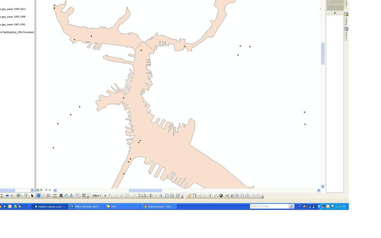
So as shown in pic I have a bunch of stations with water sample data and polygons representing the water in harbor.
The objective is to interpolate data over the water body.
To best simulate peninsula's barrier effect, I understand that I am better off with Diffusion Interpolation with Barriers and/or Kernel Interpolation with Barriers in Geostatistical Analyst Tool.
For those who are experienced in this kind of endeavor,
1. Should I aggregate the polygons first to connect the waters?
2. If I set the polygons as barriers, will it be considered islands instead of waters? With this concern, how should I best specify the parameters for the interpolation tool?
These are some really powerful tools in ArcGIS. I would love to engage in related discussions not limited to this forum.
Will check for updates frequently. Any input is appreciated!
my
13 Replies
02-12-2014
09:39 AM
- Mark as New
- Bookmark
- Subscribe
- Mute
- Subscribe to RSS Feed
- Permalink
- Report Inappropriate Content
02-13-2014
06:29 AM
- Mark as New
- Bookmark
- Subscribe
- Mute
- Subscribe to RSS Feed
- Permalink
- Report Inappropriate Content
Trying increasing the bandwidth value.
I would rather suggest you first use KernelInterpolationWithBarriers, same concept, larger bandwidth brings in more data, however, it may then over smooth the data.
Trial and error and look at using the CrossValidation tool or it can all be done in the Geostatistical Wizard.
You might want to move this post to http://forums.arcgis.com/forums/100-Geostatistical-Analyst
-Steve
02-13-2014
08:02 AM
- Mark as New
- Bookmark
- Subscribe
- Mute
- Subscribe to RSS Feed
- Permalink
- Report Inappropriate Content
Trying increasing the bandwidth value.
I would rather suggest you first use KernelInterpolationWithBarriers, same concept, larger bandwidth brings in more data, however, it may then over smooth the data.
Hi Steve
thanks for replying.
So the larger the bandwidth, the more calculation will be done right?
Since it does not have a guidance value, how do I decide what order of magnitude to start with as the bandwidth?
my
p.s. to move this thread to other forum, is there a way other than posting it again?
02-13-2014
08:07 AM
- Mark as New
- Bookmark
- Subscribe
- Mute
- Subscribe to RSS Feed
- Permalink
- Report Inappropriate Content
02-13-2014
08:29 AM
- Mark as New
- Bookmark
- Subscribe
- Mute
- Subscribe to RSS Feed
- Permalink
- Report Inappropriate Content
p.s. to move this thread to other forum, is there a way other than posting it again?
Yes there is, I have moved it for you based on Steve's suggestion. Forums MVPs have basic moderation rights and can do this.
02-13-2014
09:49 AM
- Mark as New
- Bookmark
- Subscribe
- Mute
- Subscribe to RSS Feed
- Permalink
- Report Inappropriate Content
Yes there is, I have moved it for you based on Steve's suggestion. Forums MVPs have basic moderation rights and can do this.
Thanks!
mymymymymymymy
02-13-2014
11:01 AM
- Mark as New
- Bookmark
- Subscribe
- Mute
- Subscribe to RSS Feed
- Permalink
- Report Inappropriate Content
Hi Steve
thanks for replying.
So the larger the bandwidth, the more calculation will be done right?
Since it does not have a guidance value, how do I decide what order of magnitude to start with as the bandwidth?
my
p.s. to move this thread to other forum, is there a way other than posting it again?
The default bandwidth is calculated such that it minimizes the root-mean-square crossvalidation error. However, any location that does not have any points within the bandwidth distance will be calculated as NoData. As you increase the bandwidth, the areas of NoData will get smaller, but the quality of the predictions will decline. Keeping these two issues in mind, you need to decide on a bandwidth that works for your needs.
02-13-2014
12:16 PM
- Mark as New
- Bookmark
- Subscribe
- Mute
- Subscribe to RSS Feed
- Permalink
- Report Inappropriate Content
The default bandwidth is calculated such that it minimizes the root-mean-square crossvalidation error. However, any location that does not have any points within the bandwidth distance will be calculated as NoData. As you increase the bandwidth, the areas of NoData will get smaller, but the quality of the predictions will decline. Keeping these two issues in mind, you need to decide on a bandwidth that works for your needs.
Hi Eric
Thanks for clarifying. That is crystal clear explanation. Very helpful.
On a side note, I am still not very sure about difference between mask and processing extent. When I select extent as display, I get result as if the data points outside the screen are also accounted. In terms of display and calculation respectively, what kind of role does each play?
Thanks
my
02-13-2014
12:21 PM
- Mark as New
- Bookmark
- Subscribe
- Mute
- Subscribe to RSS Feed
- Permalink
- Report Inappropriate Content
Please read through the documentation on Mask and Extent. They do a good job of explaining the concepts. If you still have questions after reading the topics, I'm happy to answer them.
Mask:
http://resources.arcgis.com/en/help/main/10.2/index.html#//001w0000001t000000
Extent:
http://resources.arcgis.com/en/help/main/10.2/index.html#//001w00000009000000
Mask:
http://resources.arcgis.com/en/help/main/10.2/index.html#//001w0000001t000000
Extent:
http://resources.arcgis.com/en/help/main/10.2/index.html#//001w00000009000000