Turn on suggestions
Auto-suggest helps you quickly narrow down your search results by suggesting possible matches as you type.
Cancel
- Home
- :
- All Communities
- :
- Industries
- :
- Water Utilities
- :
- Water Utilities Questions
- :
- Re: Sewer/Wastewater Geometric Network - Newbie
Options
- Subscribe to RSS Feed
- Mark Topic as New
- Mark Topic as Read
- Float this Topic for Current User
- Bookmark
- Subscribe
- Mute
- Printer Friendly Page
Sewer/Wastewater Geometric Network - Newbie
Subscribe
10453
10
03-02-2012 05:36 AM
03-02-2012
05:36 AM
- Mark as New
- Bookmark
- Subscribe
- Mute
- Subscribe to RSS Feed
- Permalink
- Report Inappropriate Content
Hi all, I'm wanting to put my sewer GIS data into a Geometric Network to take advantage of the tracing routines. I have a very large collection system already built in a geodatabase and I have a few questions.
1. In general practices, should service laterals be included as an Simple Edge? So when running a trace upstream it selects any/all service laterals that could be contributing. Or, should service laterals even be included in the network at all?
2. I did a simply Geometric Network test on a copy of my data once and tested the Trace Downstream. I noticed it takes any Path at a manhole structure. I'd like to ensure it takes the correct sewer main when it enters a manhole structure with multiple effluent lines by using the lowest pipe, currently using a downstream invert elevation. Is this possible?
3. Is there any issues checking data out for GPS collection? Do I have to break the network, collect points, check in points, and then re-build the network? I'm using ArcPad.
Any other general practices that I should be aware of?
Thanks in advance
10 Replies
03-04-2012
07:40 AM
- Mark as New
- Bookmark
- Subscribe
- Mute
- Subscribe to RSS Feed
- Permalink
- Report Inappropriate Content
Matt,
1: I would model them as complex. If you model them as simple and you map you cleanouts, this will split the lateral at that location into two features.
2: Check your flow direction, you can display flow arrows using a button on the Infrastructure Editing Toolbar or the Utility Network Toolbar. You can manually set the flow based on digitized direction using a tool on the Infrastructure Editing Toolbar also.
3: It should be ok to check the data out. I have not really tried this in a while though. I have ran into issues with GPS correct and GPS Analyst. You will have to build a replica GDB, drop the network, check this out for field edits, sync field edits and sync the replica back to the master. If you are just collecting new information or even trying to move existing, a lot of users find it simplier to capture new data, then inside ArcMap adjust the existing features and copy and paste the new.
Let us know if you have any more questions.
03-05-2012
06:46 AM
- Mark as New
- Bookmark
- Subscribe
- Mute
- Subscribe to RSS Feed
- Permalink
- Report Inappropriate Content
Thanks for the information, Michael. Here's some more details on my data before I start creating the network database:
1. We have thousands of laterals, but only a few known cleanout locations that we've GPS'ed to date. Do you have cleanouts as a 'source'?
2. Luckily, all or our data was input in the correct flow direction when the data was created in the late 90's, so the direction arrows are all correct. What I was referring to is when an influent pipe enters a manhole (junction) that has 2 effluent pipes, the wastewater takes the lowest pipe 99% of the time. Only when there is extremely high flow would it ever pass through the second pipe. So my question is how can I set up my sewer network to trace through the deepest pipe? I have invert elevations measured in sea level, it's not pipe depth. Should we be adding pipe depth to ensure the tracing in the way I described?
3. Back to sources and sinks, would lift stations and catch basins count as sinks? I'm a little confused on this function. Is there any websites you'd recommend I read regarding utility networks other than ESRI sites?
4. Lastly, what is the Infrastructure Editing Toolbar? Where is this found? I only have the Utility Network Analyst toolbar.
I appreciate all your advice.
Regards,
Matt
03-05-2012
07:05 AM
- Mark as New
- Bookmark
- Subscribe
- Mute
- Subscribe to RSS Feed
- Permalink
- Report Inappropriate Content
1. We have thousands of laterals, but only a few known cleanout locations that we've GPS'ed to date. Do you have cleanouts as a 'source'?
A: No, You should model the treatment plant or the pump as a sink and do not set anything as a source in a sewer network. With source and sinks you only want to set one or the other, not both.
2. Luckily, all or our data was input in the correct flow direction when the data was created in the late 90's, so the direction arrows are all correct. What I was referring to is when an influent pipe enters a manhole (junction) that has 2 effluent pipes, the wastewater takes the lowest pipe 99% of the time. Only when there is extremely high flow would it ever pass through the second pipe. So my question is how can I set up my sewer network to trace through the deepest pipe? I have invert elevations measured in sea level, it's not pipe depth. Should we be adding pipe depth to ensure the tracing in the way I described?
A: I am not 100% sure on this one. You could disable the pipe, this would prevent it from be traced. Try setting the enabled field to false and see what happens.
3. Back to sources and sinks, would lift stations and catch basins count as sinks? I'm a little confused on this function. Is there any websites you'd recommend I read regarding utility networks other than ESRI sites?
A: Liftstations, hard to tell without seeing your data, but I would guess no, I would try just where the system terminates, the plant.
4. Lastly, what is the Infrastructure Editing Toolbar? Where is this found? I only have the Utility Network Analyst toolbar.
A: http://www.arcgis.com/rc/item.html?id=14bdfb26bc2f4e0388a633fbd0ccca02
05-23-2012
10:01 AM
- Mark as New
- Bookmark
- Subscribe
- Mute
- Subscribe to RSS Feed
- Permalink
- Report Inappropriate Content
Hi Mike,
I still can't get the flow direction to go in the direction it was digitized. This tells me the network is 'confused' on which direction it flows. I set the WWTP as the only sink in the Network Structure feature class. I'm using the Naperville network as my example, and they don't even have any sinks that I've found yet their flow direction appears to be normal. I have indeterminate flow even at the farthest reaches of my dataset.
We have a LOT of lift stations. If I set a lift station as a sink, every pipe upstream now has proper flow direction; but then the downstream flow goes into the lift station as well. You said in the last post I could "manually" set the flow direction using a tool on the Utility Network Analyst Toolbar, but I don't see that tool, unless you meant the Set Flow Direction tool in which case how do I force the flow direction? Pretty much every pipe flows through several lift stations to ultimately reach the WWTP.
Lastly, when I fix the build errors (SewerNet_BuildERR) and run the Network Build Errors tool on the Utility Analyst Toolbar, does it update the BuildERR table?
I've been playing around with the templates and toolbar for over a week now and have yet to figure out how to fix my flow directions, so any help is appreciated.
Thanks in advance and sorry for any spelling or grammatical errors!
Matt
05-24-2012
03:15 AM
- Mark as New
- Bookmark
- Subscribe
- Mute
- Subscribe to RSS Feed
- Permalink
- Report Inappropriate Content
Matt,
Make sure the treatment plant is connected to the network. In the sample data, I believe the treatment plant was not connected. If the lines are all digitized in the correct direction, a tool on the infrastructure editing toolbar will set their flow based on digitized direction. I attached the help docs that reviews the tools.
Make sure the treatment plant is connected to the network. In the sample data, I believe the treatment plant was not connected. If the lines are all digitized in the correct direction, a tool on the infrastructure editing toolbar will set their flow based on digitized direction. I attached the help docs that reviews the tools.
05-31-2012
01:02 PM
- Mark as New
- Bookmark
- Subscribe
- Mute
- Subscribe to RSS Feed
- Permalink
- Report Inappropriate Content
Excellent. I appear to be on the right track now.
I've got my tracing running, but I still have some wacky scenarios out in the field I need some advice with. One key issue is I have one manhole with a 78" pipe as the lowest pipe running east-west for reference. Same manhole has a 12" pvc pipe running north-south much more shallow. I need the trace program to differentiate these pipes. If I run the trace upstream on the 12" it also selects the 78" even though there is no connection, I need it to ignore the deeper pipe. Currently the manhole is in the manhole feature class, should it move to some other kind of feature class? Any advice?
Thanks in advance
Matt
08-13-2014
07:13 PM
- Mark as New
- Bookmark
- Subscribe
- Mute
- Subscribe to RSS Feed
- Permalink
- Report Inappropriate Content
FYI I just discovered the Geometric Network Configuration Manager addin.
Very Handy for the establishment and Import/Export of a Geometric Network...
http://www.arcgis.com/home/item.html?id=fa4e4cdd3bf64be7a1287fd1fd12e2f1
04-29-2015
08:17 AM
- Mark as New
- Bookmark
- Subscribe
- Mute
- Subscribe to RSS Feed
- Permalink
- Report Inappropriate Content
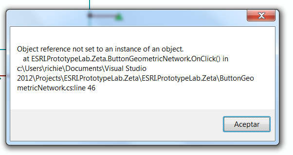
i tried to install as i have with other add-ins, get de installation succesful mesage and then i get this when i try to launch the manager....
04-29-2015
02:45 PM
- Mark as New
- Bookmark
- Subscribe
- Mute
- Subscribe to RSS Feed
- Permalink
- Report Inappropriate Content
Just looking at the web page for the tool..
Geometric Network Configuration Manager | Applications Prototype Lab
Do you have ArcGIS10.2 installed and MS .NET 4.5?