Turn on suggestions
Auto-suggest helps you quickly narrow down your search results by suggesting possible matches as you type.
Cancel
- Home
- :
- All Communities
- :
- Products
- :
- Geoprocessing
- :
- Geoprocessing Questions
- :
- Re: Add X,Y data not working?
Options
- Subscribe to RSS Feed
- Mark Topic as New
- Mark Topic as Read
- Float this Topic for Current User
- Bookmark
- Subscribe
- Mute
- Printer Friendly Page
Add X,Y data not working?
Subscribe
22779
16
04-19-2012 01:37 PM
04-19-2012
01:37 PM
- Mark as New
- Bookmark
- Subscribe
- Mute
- Subscribe to RSS Feed
- Permalink
- Report Inappropriate Content
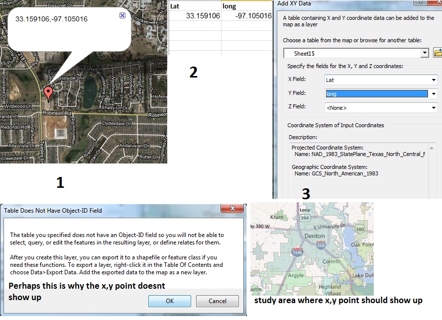
I am simply trying to make point shapefiles from x,y data. It doesn't seem to work, perhaps I am doing it incorrectly. Please check the image below it fully illustrates the issue I am having.
[ATTACH=CONFIG]13683[/ATTACH]
Thank you
[ATTACH=CONFIG]13683[/ATTACH]
Thank you
16 Replies
04-30-2012
09:20 PM
- Mark as New
- Bookmark
- Subscribe
- Mute
- Subscribe to RSS Feed
- Permalink
- Report Inappropriate Content
Samantha,
Please follow these Steps to avoid further confusion:
1. go to your original spreadsheet and re-label the columns Field_Y_Latitude (the ones like 33.159106) and Field_X_Longitude (the -97.105016 ones).
2. resave the sheet as a .csv file called "XYPoints.csv"
3. start ArcMAP and run the Add XY Data tool browsing to input "XYPoints.csv"
4. set X Field: = Field_X_Longitude and Y Field: = Field_Y_Latitude.
5. at the bottom of the box hit EDIT... and Select in Geographic Coordinate Systems folder North Americafolder: "North American Datum 1983.prj "which will show up as GCS_North_American_1983
6. In ArcMAP table of contents Right-Click on the "XYPoints.csv Events" layer and Data > Export Data and specify the coordinate system as the layers source data in whatever file format you want Shapefile or Feature Class.
You can then either do step 6 again and use your Data Frames Projected coordinate system (assuming you have set it to that of a base map in Texas State Plane) for a projected shapefile output or use the Data Management > Projection and Transformations > Project tool and output your data into Texas State plane or whatever.
All the other posts have given correct advice, but don't bother trying to find a "solution"; you've just run into a common problem mixing up X and Y for Latitude and Longitude. Maybe it just sounds better that way.
Hardolph
05-09-2012
10:54 AM
- Mark as New
- Bookmark
- Subscribe
- Mute
- Subscribe to RSS Feed
- Permalink
- Report Inappropriate Content
Samantha,
5. at the bottom of the box hit EDIT... and Select in Geographic Coordinate Systems folder North Americafolder: "North American Datum 1983.prj "which will show up as GCS_North_American_1983
Hardolph
Thanks a ton everything worked great! I just have a question at step 5, when I am going to edit and selecting North American Datum 1983. Is that defining the coordinate system of my xy input or is it projecting it?
05-09-2012
11:07 AM
- Mark as New
- Bookmark
- Subscribe
- Mute
- Subscribe to RSS Feed
- Permalink
- Report Inappropriate Content
That definitely seems like a "Define" since that is the first time you're creating the spatial data for a raw dataset.
Thanks a ton everything worked great! I just have a question at step 5, when I am going to edit and selecting North American Datum 1983. Is that defining the coordinate system of my xy input or is it projecting it?
05-11-2012
01:00 PM
- Mark as New
- Bookmark
- Subscribe
- Mute
- Subscribe to RSS Feed
- Permalink
- Report Inappropriate Content
@Vaayu, thank you very much
Importing the excel x,y data worked great. However, using the "go to x,y" tool from the toolbar up top does not seem to work. I input the coordinates exactly as they are in the excel file. I then try different options such as zoom to, flash, or add point and it does not work. What am I doing incorrectly?
[ATTACH=CONFIG]14273[/ATTACH]
Again this is a seperate issues from the input XY data from excel, that worked great. This is using the go to xy tool.
Thanks again for your help everyone, I really appreciate it.
05-11-2012
05:15 PM
- Mark as New
- Bookmark
- Subscribe
- Mute
- Subscribe to RSS Feed
- Permalink
- Report Inappropriate Content
Samantha,
for the Go To X-Y tool with the coordinates as shown you need to change the entry format to "decimal degrees" by clicking the small drop down arrow on the right end of the toolbar. You have it selected for "degrees minute seconds" which would look more like 98 33 22 W for X and 35 48 27 N for Y in the entry windows.
Hardolph
05-11-2012
06:09 PM
- Mark as New
- Bookmark
- Subscribe
- Mute
- Subscribe to RSS Feed
- Permalink
- Report Inappropriate Content
Samantha,
for the Go To X-Y tool with the coordinates as shown you need to change the entry format to "decimal degrees"
Thanks for your reply. I changed it to decimal degrees and input the coordinates, and it does not flash or zoom to the coordinates provided.
[ATTACH=CONFIG]14275[/ATTACH]
05-11-2012
11:54 PM
- Mark as New
- Bookmark
- Subscribe
- Mute
- Subscribe to RSS Feed
- Permalink
- Report Inappropriate Content
Samantha,
it does not go to the coordinates because you have reversed the inputs: Long: = -97.080497 (the X coordinate) and Lat: = 33.155781 (the Y coordinate).
The Go To tool does not "know" that you have reversed them, but there is no latitude -97.080497 or anything above -90 for that matter in degrees, so it just sits.
[ATTACH=CONFIG]14279[/ATTACH]
Hardolph
- « Previous
-
- 1
- 2
- Next »
- « Previous
-
- 1
- 2
- Next »