Turn on suggestions
Auto-suggest helps you quickly narrow down your search results by suggesting possible matches as you type.
Cancel
- Home
- :
- All Communities
- :
- Products
- :
- Data Management
- :
- Data Management Questions
- :
- Georeferencing Toolbar tools stay grayed out---wil...
Options
- Subscribe to RSS Feed
- Mark Topic as New
- Mark Topic as Read
- Float this Topic for Current User
- Bookmark
- Subscribe
- Mute
- Printer Friendly Page
Georeferencing Toolbar tools stay grayed out---will not activate
Subscribe
6430
4
08-04-2011 12:06 PM
08-04-2011
12:06 PM
- Mark as New
- Bookmark
- Subscribe
- Mute
- Subscribe to RSS Feed
- Permalink
- Report Inappropriate Content
I have a raster image (GEOTIFF format) loaded in ArcView 9.2, along with TIGER Census vector files of roads. Am attempting to use the Link Points function on the Georeferencing toolbar to align the raster file to the vector data. Problem: The Link Points function on the Georeferencing toolbar stays grayed out. I can't get it to activate.
The Georeferencing toolbar is visible, and I am in an Editing session. The title of the raster file displays in the Georeferencing window.
Any ideas?
The Georeferencing toolbar is visible, and I am in an Editing session. The title of the raster file displays in the Georeferencing window.
Any ideas?
4 Replies
08-08-2011
09:01 AM
- Mark as New
- Bookmark
- Subscribe
- Mute
- Subscribe to RSS Feed
- Permalink
- Report Inappropriate Content
Is your data frame coordinate system the same as the raster coordinate system? Also, here is a helpful KB article.
08-15-2011
06:54 PM
- Mark as New
- Bookmark
- Subscribe
- Mute
- Subscribe to RSS Feed
- Permalink
- Report Inappropriate Content
JSkinn3, thanks for your response. Once I get back off vacation, and get back to the office and my ArcGIS software and datasets, I'll try using the fixes the article recommended.
10-23-2012
05:33 AM
- Mark as New
- Bookmark
- Subscribe
- Mute
- Subscribe to RSS Feed
- Permalink
- Report Inappropriate Content
Is your data frame rotated? You cannot use georeferencing while your data frame is rotated.
01-20-2017
05:33 AM
- Mark as New
- Bookmark
- Subscribe
- Mute
- Subscribe to RSS Feed
- Permalink
- Report Inappropriate Content
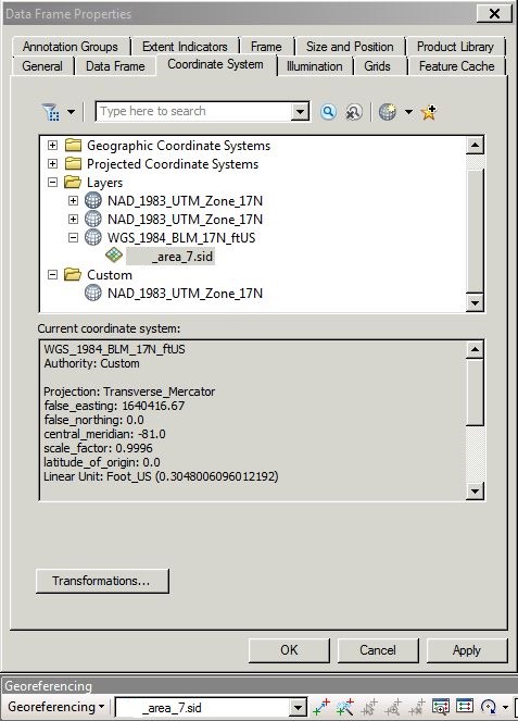
I've found a workaround. In the Data Frame Properties for the data frame that you need to georeference, go to Coordinate System. Expand layers, then the coordinate system assigned to your imagery, then click on the imagery layer that you want to georeference. It should change the Georeferencing toolbar from grayed out to active.