Turn on suggestions
Auto-suggest helps you quickly narrow down your search results by suggesting possible matches as you type.
Cancel
- Home
- :
- All Communities
- :
- Products
- :
- 3D
- :
- 3D Questions
- :
- Extract point elevation data from TIN
Options
- Subscribe to RSS Feed
- Mark Topic as New
- Mark Topic as Read
- Float this Topic for Current User
- Bookmark
- Subscribe
- Mute
- Printer Friendly Page
Extract point elevation data from TIN
Subscribe
11626
5
12-13-2011 04:38 AM
12-13-2011
04:38 AM
- Mark as New
- Bookmark
- Subscribe
- Mute
- Subscribe to RSS Feed
- Permalink
- Report Inappropriate Content
We got TIN data covering river banks, and want to extract the elevation along banks. Here is my workflow:
1 convert river bank polyline shapefile to point shapefile,
2 extract point elevation from TIN. It seems i need to set barrier. I Googled and easily find how to build a TIN from existing point survey, but little on extract point elevation from TIN. I suppose ArcGIS has an existing tool for that.
Note we do not want to convert the TIN to Raster, which will loss resolution.
Any suggestions are appreciated.
Hailiang
5 Replies
12-13-2011
08:37 AM
- Mark as New
- Bookmark
- Subscribe
- Mute
- Subscribe to RSS Feed
- Permalink
- Report Inappropriate Content
12-13-2011
10:14 AM
- Mark as New
- Bookmark
- Subscribe
- Mute
- Subscribe to RSS Feed
- Permalink
- Report Inappropriate Content
Greetings,
Please check out the Add Surface Information tool.
Regards,
Eric
Thanks Eric, that tool is what i need.
Now when i go to question 1, converting from polyline to point shapefile, I get problem. I know it is possible to use a script to convert the vertices of polyline to points, but that cannot meet my need. Since in relatively strait portion, there is too few nodes, and it is tedious to add more manually. Is there any tool allowing me to select a segment and add a desired number of points within the segment?
04-25-2013
09:11 AM
- Mark as New
- Bookmark
- Subscribe
- Mute
- Subscribe to RSS Feed
- Permalink
- Report Inappropriate Content
I know this is well past the date you originally posted--but it seems like the Densify tool (ArcToolbox > Editing Tools > Densify) could solve your issue.
Warren
Warren
08-15-2013
01:58 PM
- Mark as New
- Bookmark
- Subscribe
- Mute
- Subscribe to RSS Feed
- Permalink
- Report Inappropriate Content
Hello All
I have a similar issue. The title exactly matches my problem, but the suggestions do not. I have a point file (~160 x 200) of 1km spaced points and am wanting to extract the z values of 30 separate TINs, which are spatially equivalent to this pointfile.
I'm familiar with 'Extract Values to Points' but this only works with rasters; I'm wanting to avoid this as rasters have inherent interpolation problems (especially for projected ones), but there doesn't seem to be a similar tool for TINs.
Also, 'Interpolate Shape; generates an empty '0' column (even when I run everything using Geo Coordinates (WGS-84)). I've been messing about with this most of the day and am stumped!
Help, please. Thank you.
Stephen
08-16-2013
05:22 PM
- Mark as New
- Bookmark
- Subscribe
- Mute
- Subscribe to RSS Feed
- Permalink
- Report Inappropriate Content
Hello Stephen,
You can setup a model that accomplishes this task in less than 2 minutes! Here's how:
[ATTACH=CONFIG]26767[/ATTACH]
Try the attached toolbox and let me know how it works out. Please note that if your file names are greater than 10 characters and the input file is a shapefile, the Add Field step will fail because the dbf format does not support field names larger than 10 characters.
Regards,
Khalid
You can setup a model that accomplishes this task in less than 2 minutes! Here's how:
[ATTACH=CONFIG]26767[/ATTACH]
- Create a new model in a toolbox & edit it (happens automatically when you create the new model)
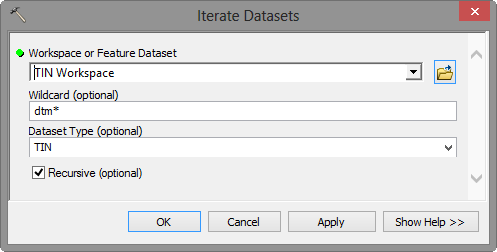
- Select the Insert menu > Iterators option & choose "Datasets"
- Edit Iterate Datasets so the Dataset Type parameter is set to "TIN"
- Add the "Add Surface Information" tool, specify the input points, select the Z property, and set the "TIN" output from Iterate Datasets to the Surface parameter
- Add the "Add Field" tool and specify the Name variable for the Field Name parameter with Field Type set to double
- Add the "Calculate Field" tool, specify %Name% in Field Name parameter and Z field in Expression parameter
[ATTACH=CONFIG]26769[/ATTACH]
[ATTACH=CONFIG]26770[/ATTACH]
[ATTACH=CONFIG]26771[/ATTACH]
Try the attached toolbox and let me know how it works out. Please note that if your file names are greater than 10 characters and the input file is a shapefile, the Add Field step will fail because the dbf format does not support field names larger than 10 characters.
Regards,
Khalid