- Home
- :
- All Communities
- :
- User Groups
- :
- New to GIS
- :
- Questions
- :
- How do I creating a basemap using my own *.PNG or ...
- Subscribe to RSS Feed
- Mark Topic as New
- Mark Topic as Read
- Float this Topic for Current User
- Bookmark
- Subscribe
- Mute
- Printer Friendly Page
How do I creating a basemap using my own *.PNG or *.TIFF files?
- Mark as New
- Bookmark
- Subscribe
- Mute
- Subscribe to RSS Feed
- Permalink
- Report Inappropriate Content
How does one create a STATIC basemap (or STATIC layer) using ArcMap (Arc-GIS Pro/Desktop) using my very own *.TIFF or *.PNG files?
And if I want to get really fancy, how do I the same, but create a LAYER to which I can tie ("clip"??? whatever???) to an existing "out-of-the-box" ERSI/Arc-GIS basemap using ARC-GIS Pro/Desktop's ArcMap? Or, do I use another module other than ArcMAP?
These image files are NOT to be used for any dynamic fancy data analysis or anything else -- they are simply a basemap of existing surveys and county maps that I'd like to use as either:
a) a BASEMAP; and/or
b) a LAYER with some dimming or transparency as an overlay atop the "out-of-the-box" ERSI U.S. Roadmaps Basemap...
NOTHING FANCY / NOTHING DEMOGRAPHICAL or ANALYTICAL -- JUST A STATIC LAYER!
This has to be easier than spending ANOTHER 27 hours I've already spent reading the ARC-GIS manuals.
- Mark as New
- Bookmark
- Subscribe
- Mute
- Subscribe to RSS Feed
- Permalink
- Report Inappropriate Content
Hi Joseph, you create a raster basemap, by adding your tiff to ArcMap, and then georeferencing it. You'll need to use an existing layer to match it to, usually an orthophoto of some kind. I know you said you were trying to avoid reading, but you're basically going to have to read the georeferencing help file, whether you use the one from ESRI, or have someone else retype the same information here  : Fundamentals of Georeferencing a Raster
- Mark as New
- Bookmark
- Subscribe
- Mute
- Subscribe to RSS Feed
- Permalink
- Report Inappropriate Content
Additionally, you can use this same georeferenced image as your basemap, or lay it over another basemap and give it some transparency in the layer properties. Turning it into a vector layer will basically mean digitizing each feature. Not sure if this answers the second part of your question or not.
- Mark as New
- Bookmark
- Subscribe
- Mute
- Subscribe to RSS Feed
- Permalink
- Report Inappropriate Content
Thanks, Sephe...
I think I've made this more confusing and over-complicated things far more than they need to be for my own good. I followed so many tutorials used all these various conversion tools (Raster to Polygon, etc) and I've only confused myself more.
OK. According to the "Fundamentals of Georef'g a Raster", it says simply to:
1) "In ArcMap, ADD the raster that you want to align with your projected data."
This is that "easy" step where I don't even know where to begin at this point. While I don't mind reading the more complex points in the helpful piece to which you referred me --and confident I can do the rest-- I do not know which menu item to begin "ADDING THE RASTER [I| want to align with [my] projected data"...
I am relatively technical, but not a GIS professional.
Once I get this initial step done, I'm confident that I can do the rest.
Thanks again, Sephe!
- Mark as New
- Bookmark
- Subscribe
- Mute
- Subscribe to RSS Feed
- Permalink
- Report Inappropriate Content
Do I simply go to "Add Data" and choose my .TIFF???
It can't be THAT easy or I'm jumping out the window...
(Joking, of cousre)
- Mark as New
- Bookmark
- Subscribe
- Mute
- Subscribe to RSS Feed
- Permalink
- Report Inappropriate Content
Yes, you just hit "Add data" and choose your tiff.
But before doing so, be sure there are a few things you want to set up:
- Add to ArcMap the data that you will be using to align your tiff to. Be sure to do this BEFORE adding your tiff. The reason to add it before is that ArcMap will default to the coordinate system of the first layer added; your tiff has no coordinate system.
- Once you get the reference data in, check to see what the coordinate system is.
- In ArcMap, Table of Contents area, right-click on Layers.
- Choose "Properties" from the list.
- Click on the "Coordinate System" tab.
- Check to see what coordinate system was chosen. Be sure it is a "Projected Coordinate System" (scroll up to see what heading the system is under). If it is a "Geographic Coordinate System", you will need to decide on an appropriate Projected Coordinate System (which is a much larger discussion than can be explained at this juncture).
Chris Donohue, GISP
- Mark as New
- Bookmark
- Subscribe
- Mute
- Subscribe to RSS Feed
- Permalink
- Report Inappropriate Content
Yes, Joseph, as Chris says, you just have to add your raster using the add button. Please don't jump out of the window though. You've only just begun on your georeferencing journey, and I'm sure there will be roadblocks ahead! Aside from the important things Chris mentioned, you are going to want to choose a layer to reference it to that has some of the same features, and that haven't changed. For example, a building, or a road intersection. Let us know if anything else trips you up! This is a fairly simple procedure once you have done it, but I know at first it can seem like some crazy science.
- Mark as New
- Bookmark
- Subscribe
- Mute
- Subscribe to RSS Feed
- Permalink
- Report Inappropriate Content
You all are great!
1) I've added the raster using, <File>, <Add Data>, <+Add Data>...
2) Then, attached my PNG (pseudo-thumbnail sample is attached).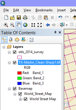
3) The image does not show on the may itself yet, but also has some RGB references on the layer panel (see thumbnail).

4) I went to the <Georeferencing> dropdown menu, and the only way I could get it to show on the map as a layer was to choose <Fit to Display>, but that's obviously a mistake, b/c now it appears I'll have to delete the layer becuz it does not match with the county line/boundaries of both this raster layer and my basemap (U.S. Roads), UNLESS there is still a way to adjust it to match my basemap, as it does not match up to the county corners...
I don't expect you guys to walk all the way thru this with me, BUT... perhaps it can help others get the hang of the concepts by doing thru my trial and error and learning.
~JG
- Mark as New
- Bookmark
- Subscribe
- Mute
- Subscribe to RSS Feed
- Permalink
- Report Inappropriate Content
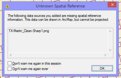
I also get an error/dialogue box that pops up that says:
"The following data sources you added are missing spatial reference info. This data can be drawn in ArcMap, but cannot be projected..."
- Mark as New
- Bookmark
- Subscribe
- Mute
- Subscribe to RSS Feed
- Permalink
- Report Inappropriate Content
Oh, so, first you add your basemap that is already georeferenced. Make sure it has an appropriate projection, as Chris warned. Then you add the raster you want to georeference. Scroll and zoom until you are close to the view that your raster takes up (from previous visual inspection), and THEN use "fit to display". Your raster will be fit to the extent of your view. You can always do it again if you want to get closer. After this you fine tune the fit by creating control points--first click on a part of your raster that you can identify on the basemap, then click on the corresponding location on the basemap. Make at least 4 or 5 points, and spread them around the raster if you can. Then you click Update Georeferencing. Look at this for the specific steps:ArcGIS Help 10.1