- Home
- :
- All Communities
- :
- Industries
- :
- Transportation
- :
- Roads and Highways
- :
- Roads and Highways Questions
- :
- Create Route Layer
- Subscribe to RSS Feed
- Mark Topic as New
- Mark Topic as Read
- Float this Topic for Current User
- Bookmark
- Subscribe
- Mute
- Printer Friendly Page
Create Route Layer
- Mark as New
- Bookmark
- Subscribe
- Mute
- Subscribe to RSS Feed
- Permalink
- Report Inappropriate Content
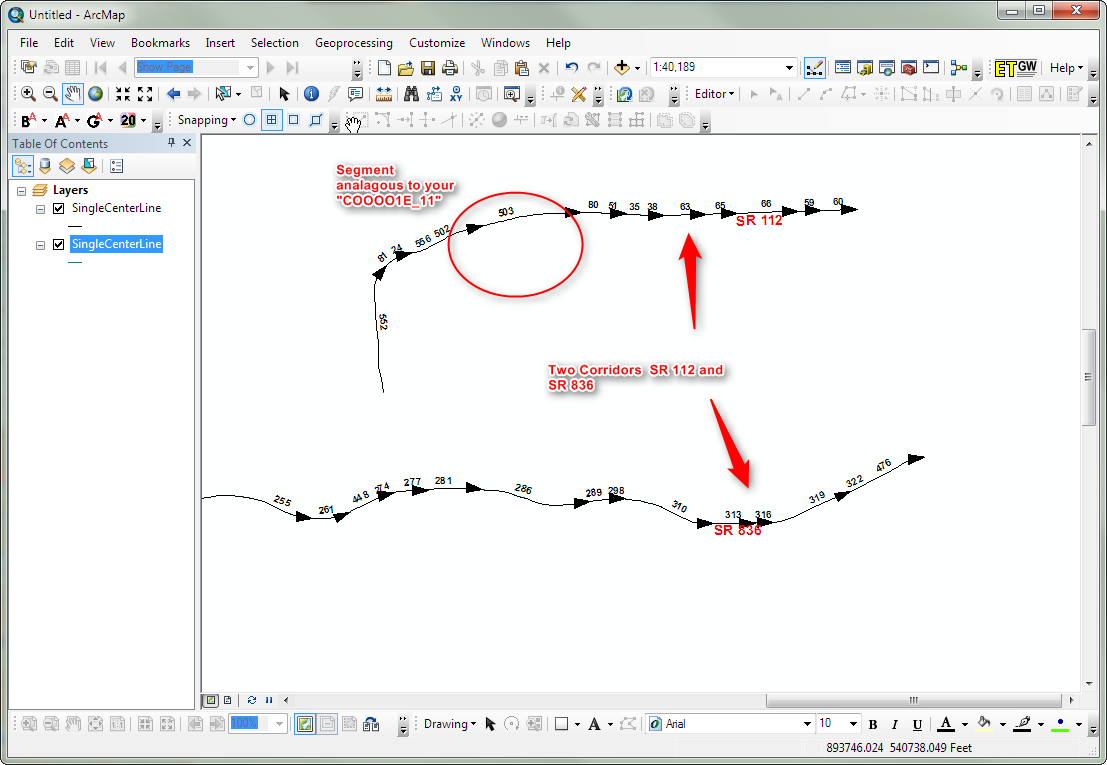
I'll try and explain what I have and what I'm trying to accomplish. It seems like it should be simple but I'm struggling. I have a Measured layer that has segments for each mile along a route. In the table I have the Route_Id which looks like this. C000001E_12 for example. The C stands for Corridor. The 000001 is the route name. the E is the roadbed identifier and the 12 would be the mile post. So for C000001E there are several mile posts or C000001E_0, C000001E_1, C000001E_2 and so on until the end of the route. Each one of these segments has a length field which denotes the length of that mile. some are long and some are short miles. I'm wanting to create a route segment based on the mile posts. I was thinking I could create a line layer that has the specific C000001E with individual mile post records and their lengths. Has anyone done anything similar or can you help point me in the right direction?
TIA
Terry
- Mark as New
- Bookmark
- Subscribe
- Mute
- Subscribe to RSS Feed
- Permalink
- Report Inappropriate Content
I am only guessing on what your after but maybe this will help:
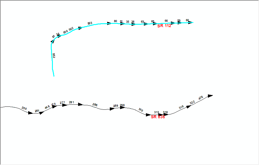
I do this periodically on our measured routes which are created from multiple segment centerlines (multiple segments that have varied lengths). Under the Selection tab, Select by Attributes. For the where clause I use something this (insert your own field names) left([Route],10) = '836042520W'. This will select all the segments that have a Route name with that portion of the route name your case something like left([Route_ID],8)= 'C000001E'). From the selection I then create a single route with that ID. You would not add the individual mile post records but use them as an event table against the single route you just created since the from to measures are already known or can be calculated from your naming scheme.
One import thing to mention is that your segment that will be composing your route all run in the same direction (beg and ends) increasing in the same direction, if not you will have to "flip" those segments not drawn in the proper directions.
Hopefully this does not cause more confusion.
- Mark as New
- Bookmark
- Subscribe
- Mute
- Subscribe to RSS Feed
- Permalink
- Report Inappropriate Content
This makes sense to me but not sure where the selection tab is.. Which linear referencing tool do I use? This does sound just like what I want to perform. My goal is to create the process and then create a model and then create a geoprocessing service.
- Mark as New
- Bookmark
- Subscribe
- Mute
- Subscribe to RSS Feed
- Permalink
- Report Inappropriate Content
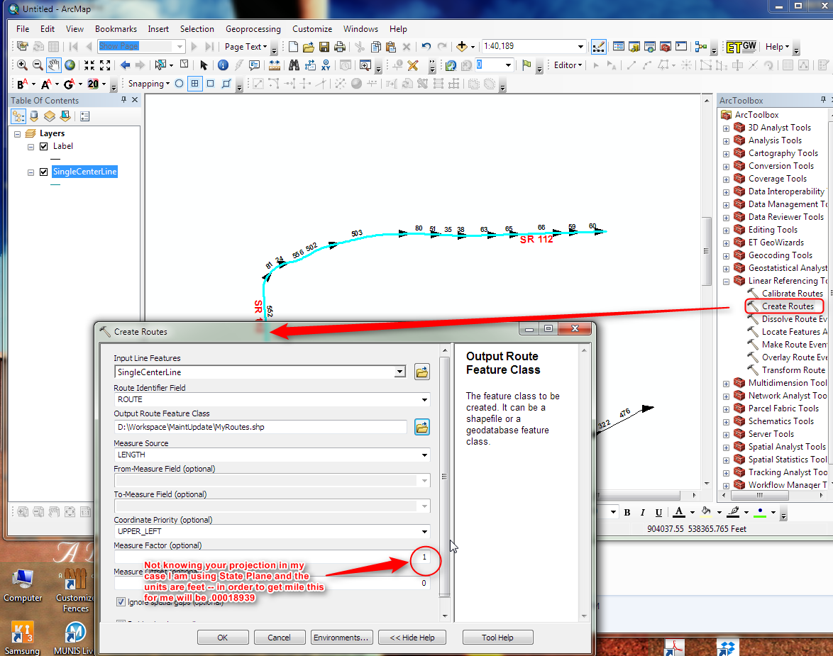
There are lots of ways to create and edit a Linear Reference. I would suggest you look through the esri help and tutorial to get a feel for it. However I can show you one way (may not be the best way for you) but it basically creates a LRS with all your corridor segments.

- Mark as New
- Bookmark
- Subscribe
- Mute
- Subscribe to RSS Feed
- Permalink
- Report Inappropriate Content
- Mark as New
- Bookmark
- Subscribe
- Mute
- Subscribe to RSS Feed
- Permalink
- Report Inappropriate Content
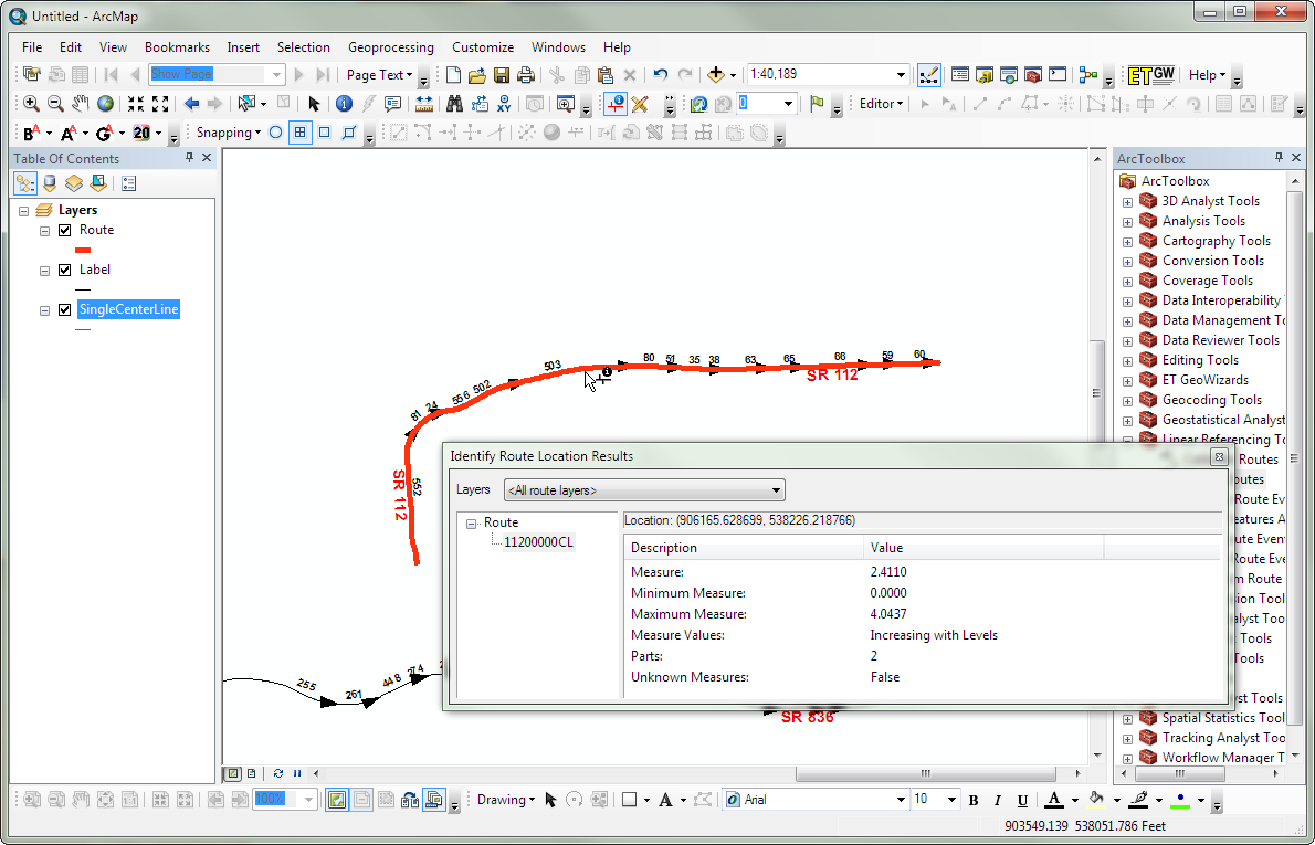
Would the Dissolve tool accomplish what you are trying to do? Assuming there is a field in the table identifying the Corridor and Roadbed (C000001E), then you should be able to dissolve all features based on this field. So all features that have the same Corridor and Roadbed, would be merged into one feature.
- Mark as New
- Bookmark
- Subscribe
- Mute
- Subscribe to RSS Feed
- Permalink
- Report Inappropriate Content
Yes you can dissolve the segments to one line and then create a route -- lots of ways to the solution.
- Mark as New
- Bookmark
- Subscribe
- Mute
- Subscribe to RSS Feed
- Permalink
- Report Inappropriate Content
Ted,
Have you done anything with Web App builder?
- Mark as New
- Bookmark
- Subscribe
- Mute
- Subscribe to RSS Feed
- Permalink
- Report Inappropriate Content
I was thinking dissolve might work to create one measure per corridor. Then the measure could be broken up into each mile and its respective length. So when I create a GP service I can locate create a route segment based on the newly created corridor measure.
- Mark as New
- Bookmark
- Subscribe
- Mute
- Subscribe to RSS Feed
- Permalink
- Report Inappropriate Content
I have not done anything with the ESRI Web components. I use my own home grown set up here since the company does not yet want to purchase the software.
You can dissolve and but the process of creating a linear reference already dissolves the individual segments into one... In the pictured example I sent each corridor is composed of many segments and the creation a route dissolves that into one single line composed of measures?