- Home
- :
- All Communities
- :
- Products
- :
- ArcGIS Hub
- :
- ArcGIS Hub Questions
- :
- Importing data from excel to create polygons
- Subscribe to RSS Feed
- Mark Topic as New
- Mark Topic as Read
- Float this Topic for Current User
- Bookmark
- Subscribe
- Mute
- Printer Friendly Page
Importing data from excel to create polygons
- Mark as New
- Bookmark
- Subscribe
- Mute
- Subscribe to RSS Feed
- Permalink
- Report Inappropriate Content
Hello,
I am new to ARCGIS and had a question about the best way to import polygon data from a csv into ARCGIS.
I am able to import a csv file which has lat/long points to create an XY event layer, and then create a shapfile, etc. I was wondering what the best way would be to do this for polygon data. I am going to have a csv file which has the lat/long of the vertexes of the polygons and some of the polygon areas will be square (and have four vertexes), however some of the polygons will have more complex shapes and may have 10 or more vertexes. I am aware of the Points to Line and Feature to Polygon tools, which I think will allow me to import the vertexes to create one polygon.
However I have 200 or so polygons to import into my map, so this will take a long time. Is there an easy way to bring in the batch data points to create all of my polygons at once? Do I need to get some add-in tool?
Thanks very much
Brendan
- Mark as New
- Bookmark
- Subscribe
- Mute
- Subscribe to RSS Feed
- Permalink
- Report Inappropriate Content
My first question would be what is the source of the data? Recreating polygons from a stream of points is definitely possible in a variety of ways, but the most elegant will entail python programming. If your data came from a gps unit, then it is possible to recreate polylines/polygons if you have the track information and the tracks represent closed-loops. So some background might save some time
Addendum
if you have a list of lists of point objects (ie xy pairs) you can construct polygons using the following. The construction of the point objects will depend on the nature of your input data, and is left for elsewhere
output_shp - an output file name including path
SR - a spatial reference object
pnts - a list of point objects (nested, a list for each polygon inside a list)
def output_polygons(output_shp,SR,pnts):
    """produce the output polygon shapefile"""
    msg = '\nRead the script header... A projected coordinate system required'
    assert (SR != None) and (SR.type=='Projected'), msg
    polygons = []
    for pnt in pnts:                           # create the polygon geometry
        polygons.append(arcpy.Polygon(arcpy.Array([arcpy.Point(*xy) for xy in pnt]),SR))
    if arcpy.Exists(output_shp):               # overwrite any existing versions
        arcpy.Delete_management(output_shp)
    arcpy.CopyFeatures_management(polygons, output_shp)
- Mark as New
- Bookmark
- Subscribe
- Mute
- Subscribe to RSS Feed
- Permalink
- Report Inappropriate Content
Last year I created a simple tool to allow some coworkers to convert data in Excel format to polygons.
It is based on the following format:
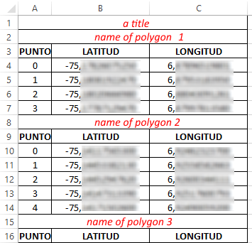
They save the Excel file as textfile (tab delimited)
The parameters are as follows:
Code:
# -*- coding: utf-8 -*-
#-------------------------------------------------------------------------------
# Name:        PuntosPoligonosTXT.py
# Purpose:    covertir puntos a poligonos
#
# Author:      xbakker
#
# Created:    10/04/2015
#-------------------------------------------------------------------------------

import arcpy
import os

def main():
    import sys
    import traceback

    try:
        arcpy.env.overwriteOutput = True

        # first parameter is txt file
        txt = arcpy.GetParameterAsText(0)

        # forth parameter (provide default NOMBRE)
        fld_name = arcpy.GetParameterAsText(1)

        # second parameter is output fc
        fc_out = arcpy.GetParameterAsText(2)

        # third parameter is spatial reference
        sr = arcpy.GetParameter(3)

        # create empty output fc
        ws_name, fc_name = os.path.split(fc_out)
        geomtype = "POLYGON"
        arcpy.CreateFeatureclass_management(ws_name, fc_name, geomtype, spatial_reference=sr)

        # add field
        arcpy.AddField_management(fc_out, fld_name, "TEXT", field_length=255)

        # start insert cursor
        flds = ("SHAPE@", fld_name)
        with arcpy.da.InsertCursor(fc_out, flds) as curs:

            # read input file
            cnt = 0
            nombre = ""
            first_point = None
            lst_pnt = []

            with open(txt, 'r') as f:
                for line in f.readlines():
                    cnt += 1
                    if cnt > 1:
                        line = line.replace('\n','')
                        lst_line = line.split('\t')
                        a = lst_line[0]
                        if a.isdigit():
                            # point
                            if bln_start:
                                first_point = GetPoint(line)
                                pnt = GetPoint(line)
                                lst_pnt.append(pnt)
                            else:
                                pnt = GetPoint(line)
                                lst_pnt.append(pnt)
                            bln_start = False
                        else:
                            # name or header
                            if a[:5].upper() == 'PUNTO':
                                pass
                            else:
                                if first_point != None:
                                    lst_pnt.append(first_point)

                                if len(lst_pnt) > 2:
                                    # create previous polygon and write to fc
                                    polygon = arcpy.Polygon(arcpy.Array(lst_pnt), sr)
                                    curs.insertRow((polygon, nombre, ))
                                lst_pnt = []
                                nombre = line.strip()
                                bln_start = True
                                arcpy.AddMessage("Procesando poligono: '{0}'".format(nombre))

                if first_point != None:
                    lst_pnt.append(first_point)
                    polygon = arcpy.Polygon(arcpy.Array(lst_pnt), sr)
                    curs.insertRow((polygon, nombre, ))

    except:
        tb = sys.exc_info()[2]
        tbinfo = traceback.format_tb(tb)[0]
        pymsg = "Errores de Python:\nTraceback info:\n" + tbinfo + "\nError Info:\n" + str(sys.exc_info()[1])
        msgs = "Errores de ArcPy:\n" + arcpy.GetMessages(2) + "\n"
        arcpy.AddError(pymsg)
        arcpy.AddError(msgs)


def GetPoint(line):
    line = line.replace(',','.')
    lst_line = line.split('\t')
    x = float(lst_line[1])
    y = float(lst_line[2])
    return arcpy.Point(x, y)

if __name__ == '__main__':
    main()