- Home
- :
- All Communities
- :
- Products
- :
- ArcGIS Pro
- :
- ArcGIS Pro Questions
- :
- I am attempting to use the IDW Interpolation tool ...
- Subscribe to RSS Feed
- Mark Topic as New
- Mark Topic as Read
- Float this Topic for Current User
- Bookmark
- Subscribe
- Mute
- Printer Friendly Page
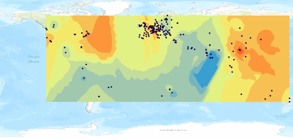
I am attempting to use the IDW Interpolation tool in order to create a raster; however it only creates an impage for a portion of the world. Is there a way to get it to wrap across the pacific ocean
- Mark as New
- Bookmark
- Subscribe
- Mute
- Subscribe to RSS Feed
- Permalink
- Report Inappropriate Content
- Mark as New
- Bookmark
- Subscribe
- Mute
- Subscribe to RSS Feed
- Permalink
- Report Inappropriate Content
I'm not sure if things work the same way in ArcGIS Pro, but if it was ArcGIS Desktop one possibility would be to check the Environments Settings to see what Extent is being used. It appears to be defaulting to the extent of your points.
Also, what projection/coordinate system are you using?
Chris Donohue, GISP
- Mark as New
- Bookmark
- Subscribe
- Mute
- Subscribe to RSS Feed
- Permalink
- Report Inappropriate Content
But even increasing the extent to cover the whole surface of Earth, is only going to make a bad situation worse. No interpolator is going to do justice to that point distribution given that you are using land-based observations (for the most part) and interpolating into oceans and the dominant area you covering.
What is it you are trying to do?
Can you not just focus on areas where you have data?
My suggestion would be to reduce the extent to subareas which have significant amounts of data.