- Home
- :
- All Communities
- :
- Industries
- :
- State & Local Government
- :
- State & Local Government Questions
- :
- Re: Geocode by Grid Name
- Subscribe to RSS Feed
- Mark Topic as New
- Mark Topic as Read
- Float this Topic for Current User
- Bookmark
- Subscribe
- Mute
- Printer Friendly Page
Geocode by Grid Name
- Mark as New
- Bookmark
- Subscribe
- Mute
- Subscribe to RSS Feed
- Permalink
- Report Inappropriate Content
I'm kind of new to GIS, so I may not have all the terminology right, but I'm hoping someone can help.
I have a table of data (concentration of chemical X) and each reading is referenced to a grid number. I have a shapefile that gives these grids a location and I can create a map with the grids on it.
I am looking for a way to use the shapefile (or a derivative of it that contains the geography) as a address locator of sorts to match each of the data points to the grid in which it was collected.
Any help or guidance would be greatly appreciated, thanks.
- Mark as New
- Bookmark
- Subscribe
- Mute
- Subscribe to RSS Feed
- Permalink
- Report Inappropriate Content
Would using a SpatialJoin work for you"
Joins attributes from one feature to another based on the spatial relationship. The target features and the joined attributes from the join features are written to the output feature class
Since you can make a map, I'm assuming the table of data already has x/y coordinates that can be represented as points (?) as an event-table and/or shapefile/featureclass. And the Grid are polygons with attributes. Using the Spatil Join can give you the information from both tables. Not quite Geocode-ing, but might be what you are needing.
- Mark as New
- Bookmark
- Subscribe
- Mute
- Subscribe to RSS Feed
- Permalink
- Report Inappropriate Content
That's the idea I'm going for, except the concentration data does not have a spatial reference except the grid reference. The grid is a shapefile with polygons for each grid, so they have the spatial information associated with them. The table of concentrations looks a little like this for clarity.
| Grid | Concentration | Collection Date |
|---|---|---|
| 123 | 15 | 9/8/16 |
| 123 | 16 | 8/30/16 |
| 124 | 20 | 9/8/16 |
Then I have a shapefile of grid polygons. Spatial join would be great, except the concentration data points do not have x/y coordinates, so I would like to derive/approximate the x/y coordinates from the grid number, then I am hoping to do all sorts of cool stuff with this data. 🙂
- Mark as New
- Bookmark
- Subscribe
- Mute
- Subscribe to RSS Feed
- Permalink
- Report Inappropriate Content
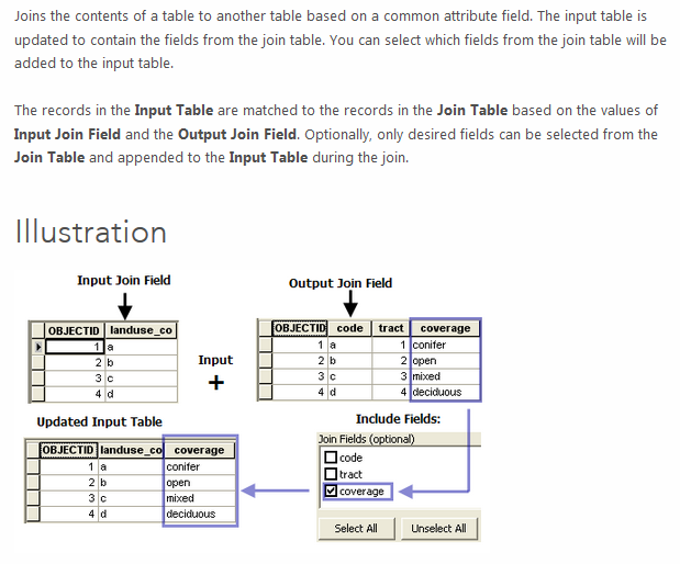
If the Grid polys have the Grid ID, and the concentration data points have the same Grid ID, you can use
Join Field—Help | ArcGIS for Desktop to make a permanent join, or use Join or Relate for temporary.

edit...and if you do this to a copy of the grid, you can then use Converting polygons to points—Help | ArcGIS for Desktop to get this to a point feature. if the grid are squares, should be the center...but there are other ways to get that too.
- Mark as New
- Bookmark
- Subscribe
- Mute
- Subscribe to RSS Feed
- Permalink
- Report Inappropriate Content
Just so I have it straight, you have a polygons shapefile in which each of the polygons are labeled in a fashion shown above, right? If so, you have the essence to geocode with:
Your 'address table' is the Concentrations table, and the 'address' of each is the value shown in the Grid column.
The data you will match your addresses to is your grid polygons. (If it's truly a shapefile, do yourself a favor and create a file geodatabase and import the shapefile into it as a feature class. You'll thank me sometime down the road)
Create a 'General- Single Field' style locator and reference the Grid-ID field as the KeyField using the polygon data as your reference data:

edit: Or you can follow rastrauch123 's excellent procedure ( that she slipped in while I was posting my suggestion....)
- Mark as New
- Bookmark
- Subscribe
- Mute
- Subscribe to RSS Feed
- Permalink
- Report Inappropriate Content
Than k you both for your help. This did exactly what I wanted it to do. I used Joe's solution and it worked beautifully. Now I have these observations spatially correlatied to the grid layer! Wahoo!
The only small caveat was that since the block ID field was a number field, so the tool would not use that field as a single line address field. I had to create a new field that was a text type field, then use the filed calculator tool to move the block ID's into it, thereby making the block ID's text. Small thing, but may be a sticking point for others looking for this solution.
Again, thank you both for your help. I'm super excited to use this to create some beautiful maps. 🙂
- Mark as New
- Bookmark
- Subscribe
- Mute
- Subscribe to RSS Feed
- Permalink
- Report Inappropriate Content
I think if you use the VB Script parser, a number will go straight into a text field. Python will want you to use the str() function:
NewTextField = str(!NumericField!)