- Home
- :
- All Communities
- :
- User Groups
- :
- Elevation Data
- :
- Questions
- :
- Re: Surface Volume Units
- Subscribe to RSS Feed
- Mark Topic as New
- Mark Topic as Read
- Float this Topic for Current User
- Bookmark
- Subscribe
- Mute
- Printer Friendly Page
Surface Volume Units
- Mark as New
- Bookmark
- Subscribe
- Mute
- Subscribe to RSS Feed
- Permalink
- Report Inappropriate Content
Hi, I finally managed to create DEM from bathymetry points and calculate the volume, but the output does not make sense. I guess I need to modify the units or coordinates. I don't know how. Here is the output (My input surface is the elevations of the bed in meters above sea level (m asl) in GCS_WGS_1984 and decimal degrees and my Plane Height is the reservoir full supply level (FSL) which is 556.87 m asl:
Plane_Height, Reference, Z_Factor, Area_2D, Area_3D, Volume
556.87, BELOW, 1.00, 0.053866900608273, 126.88623569244, 1.3850421777189
- Mark as New
- Bookmark
- Subscribe
- Mute
- Subscribe to RSS Feed
- Permalink
- Report Inappropriate Content
I don't have access to 3D Analyst, but as with a lot (all?) of the tools in Spatial Analyst, the results will be in terms of the linear unit of your input data. So, in your case, cubic degrees. Project your DEM to get units that make more sense.
- Mark as New
- Bookmark
- Subscribe
- Mute
- Subscribe to RSS Feed
- Permalink
- Report Inappropriate Content
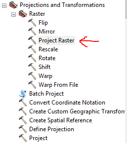
My input surface is from Topo To Raster (Type: File Geodatabase Raster Dataset), but when I want to use Raster--> Project, it doesn't let me to choose the Raster file as Input Dataset or Feature Class (The Raster file is not shown_attached screenshot). Do I need to convert the Topo To Raster to a different format first?

- Mark as New
- Bookmark
- Subscribe
- Mute
- Subscribe to RSS Feed
- Permalink
- Report Inappropriate Content
That's only for vector data. Try the Project Raster tool: