Turn on suggestions
Auto-suggest helps you quickly narrow down your search results by suggesting possible matches as you type.
Cancel
- Home
- :
- All Communities
- :
- User Groups
- :
- Web AppBuilder Custom Widgets
- :
- Questions
- :
- Printing Different Spatial Reference
Options
- Subscribe to RSS Feed
- Mark Topic as New
- Mark Topic as Read
- Float this Topic for Current User
- Bookmark
- Subscribe
- Mute
- Printer Friendly Page
Printing Different Spatial Reference
Subscribe
513
0
05-04-2017 08:01 AM
05-04-2017
08:01 AM
- Mark as New
- Bookmark
- Subscribe
- Mute
- Subscribe to RSS Feed
- Permalink
- Report Inappropriate Content
I have my services in state plane. (WKID 2270)
I have my basemap data in state plane and converted to WGS 1984
I am using the Print Plus widget but I don't think this changes anything.
We have read this article and have tired to implement what it says.
ArcGIS Online moving to Google / Bing tiling scheme: What does this mean for you? | ArcGIS Blog
When Printing
The dynamic basemap works perfectly. The Scale is printed properly and the layer matches up.
When I turn on the cache the map does not work as expected. The layers do not match up when I go to print.
The scale is correct though.
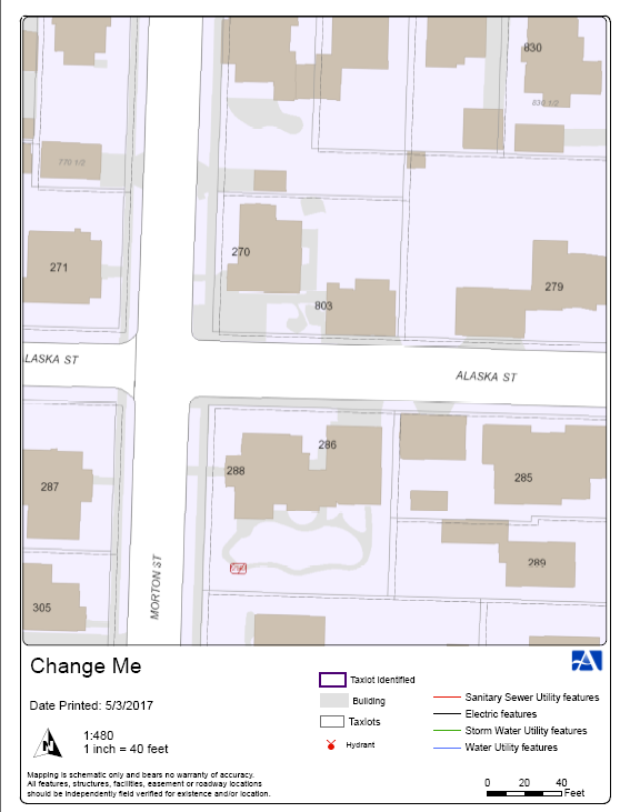
Dynamic Basemap.

Cached Basemap:
(taxlots are not aligned)
Any ideas how to get both scale and layers to work correctly for a cached basemap?
0 Replies