- Home
- :
- All Communities
- :
- Products
- :
- Mapping and Charting Solutions
- :
- Mapping and Charting Questions
- :
- Re: I need help correctly loading some GDA94, Zone...
- Subscribe to RSS Feed
- Mark Topic as New
- Mark Topic as Read
- Float this Topic for Current User
- Bookmark
- Subscribe
- Mute
- Printer Friendly Page
I need help correctly loading some GDA94, Zone54 data points from Microsoft Excel into an existing but empty feature class, that has been set up nicely with all the columns and domains ready to go for a Collector map.
- Mark as New
- Bookmark
- Subscribe
- Mute
- Subscribe to RSS Feed
- Permalink
- Report Inappropriate Content
I don't mind whether I use the Simple Data Loader wizard from ArcCatalog or the Object Loader, and although I do have domains set up, I am not importing any data into those columns (attribute fields), so it's no problem to use the Simple Data Loader.
I have managed to get the data to upload once, and have matched all my Target Fields perfectly with the Source Fields, however the problem I am having is with the spatial location of the points I am trying to load into my feature class. I know that all the data is in GDA94, Zone 54 and so is my co-ordinate system for the feature class and also my data frame.
But when I import the points, they aren't turning up in the right location. I want to know how I need to set up my Excel spreadsheet columns with my Easting and Northing data, and what the correct column headings need to be, to get the points to import with the right spatial location.
I have found an Esri article with a tutorial - Importing Data from Excel Spreadsheets - which mentions changing the column heading for Easting to UTM83Z11_E and Northing to UTM83Z11_N. Obviously this is for the datum that they were using, and not for GDA94, but I can't find anything to tell me what the correct Column heading for GDA94 would be. Could be GDA94Z54_E etc, but when I tried that I started getting "the connection for viewing your linked microsoft excel worksheet was lost" error messages. I'm not sure if that's related or a co-incidence.
Any help would be sooooooo greatly appreciated.
Lauren
- Mark as New
- Bookmark
- Subscribe
- Mute
- Subscribe to RSS Feed
- Permalink
- Report Inappropriate Content
There's no particular heading that needs to be used. You could use "a" and "b" as long as you correctly identify which one is which. I would stick to x / y or easting / northing respectively. Can you post more about the data like some sample coordinates? You say that they're GDA94 MGA 54, but could they be latitude-longitude (thus GDA94) instead? How far off are they from where they should be? Are the values importing correctly? That is, if you load the feature class by itself into a new map/data frame and check the coordinates of a point, are the coordinates the same as those in the spreadsheet? Could the x and y fields have gotten swapped?
Melita
- Mark as New
- Bookmark
- Subscribe
- Mute
- Subscribe to RSS Feed
- Permalink
- Report Inappropriate Content
Hi Melita,
I haven't been able to load the spreadsheet as it's own feature class, because when I navigate to it in ArcCatalog, right click and go to Create Feature Class --> from XY Table, it doesn't let me save as a Feature Class. I can save as a .shp but when I try to select File and Personal Geodatabase feature classes, I get an "Error Saving Object - An error occurred trying to save the object named "xxx". The same error happens when I bring the table into my map as a table, and then try and convert to a feature class through there. I'm not sure what is going on there either. I feel like there must be something wrong with my excel table.
I have attached the table that I am trying to import. All my columns match up, except for the GDA94Z54_E and GDA94Z54_N columns, which I don't have columns for in my feature class. I didn't really want columns for them because I don't want to see them in my Collector form.
Thanks,
Lauren
- Mark as New
- Bookmark
- Subscribe
- Mute
- Subscribe to RSS Feed
- Permalink
- Report Inappropriate Content
Maybe there is something that causes the error in the rest of the data. At least the single record that you attached can be converted into a featureclass with no problem.
Convert the Excel to Table:
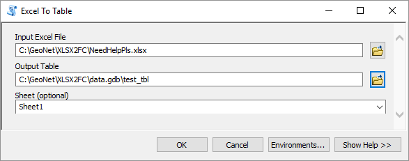
Resulting table looks fine:

Create XY events:

Export events to featureclass

The feature draws together with the event on the map:

Tale of contents:

- Mark as New
- Bookmark
- Subscribe
- Mute
- Subscribe to RSS Feed
- Permalink
- Report Inappropriate Content
I am still having trouble trying to save anything as a feature class from within my ArcMap. I have imported the following data using File-->Add Data-->Add XY Data. I have a projection set, I have checked all my column headings in excel a few times (no spaces, commas etc), have changed them to text.
My data looks ok to me in the table.

And in properties.

But when I right-click my data in the Table of Contents, and select Export Data.... I can only save the output feature class in it's default location. I can't save it to where I want to, and I can't move it after the fact either. Is it designed to be like that or am I doing something wrong?
- Mark as New
- Bookmark
- Subscribe
- Mute
- Subscribe to RSS Feed
- Permalink
- Report Inappropriate Content
You should right click on the XY events layer to export as a featureclass, not on the table. Click on Browse in the Export Data dialog window:

Select the type of the output featureclass (in the lower part of the dialog) and navigate to the output folder and select an appropriate output location (folder for shapefile, File Geodatabase to create a featureclass inside the FGDB):
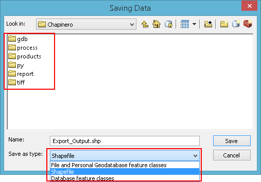
In the example below the "File and Personal Geodatabase feature classes" is selected and this allows me to store the output as featureclass in the FGDB:

- Mark as New
- Bookmark
- Subscribe
- Mute
- Subscribe to RSS Feed
- Permalink
- Report Inappropriate Content
That's exactly what I did. However I think I have discovered my problem that I was trying to save it in a location that was not a geodatabase.
Thank you for all your assistance.