- Home
- :
- All Communities
- :
- User Groups
- :
- 911 GIS
- :
- Questions
- :
- Re: How to draw basin midline in Arcmap
- Subscribe to RSS Feed
- Mark Topic as New
- Mark Topic as Read
- Float this Topic for Current User
- Bookmark
- Subscribe
- Mute
- Printer Friendly Page
How to draw basin midline in Arcmap
- Mark as New
- Bookmark
- Subscribe
- Mute
- Subscribe to RSS Feed
- Permalink
- Report Inappropriate Content
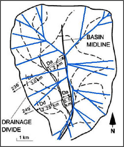
I am trying to calculate topographic symmetry. For this need to have a distance between mid line of a basin to streams and divided, like shown in Figure.
any one please let me know how to draw a mildline of basin in Arcmap.

- Mark as New
- Bookmark
- Subscribe
- Mute
- Subscribe to RSS Feed
- Permalink
- Report Inappropriate Content
For hydrology related challenges I would probably first look at ArcHydro (yellow.esri.com - /archydro/archydro/ ). Perhaps the basin length or longest flow path could be of any help:see http://downloads.esri.com/archydro/archydro/Tutorial/Doc/Arc%20Hydro%20Tools%202.0%20-%20Tutorial.pd... page 84 or see http://downloads.esri.com/archydro/archydro/Tutorial/Doc/Arc%20Hydro%20GP%20Tools%202.0%20-%20Tutori... page 100.
There is also a set of tools (Polygon to Centerline, http://www.arcgis.com/home/item.html?id=bc642731870740aabf48134f90aa6165 )that get's you a bit closer, but it will require some manual editing afterwards.
Edit: cross reference to https://community.esri.com/groups/arc-h?sr=search&searchId=6e2a4125-d277-4a64-8831-008905396533&sear... and https://community.esri.com/community/gis/solutions/arc-hydro?sr=search&searchId=6e2a4125-d277-4a64-8...
- Mark as New
- Bookmark
- Subscribe
- Mute
- Subscribe to RSS Feed
- Permalink
- Report Inappropriate Content
You may reach a larger and more pertinent audience if you were to post this in a more applicable space. The 9-1-1 GIS community while well versed, and very talented is rather limited in size and may not have the expertise you seek in this issue.