- Home
- :
- All Communities
- :
- Industries
- :
- Public Safety
- :
- Public Safety Questions
- :
- Re: Topology AddIn Guinea Pig wanted
- Subscribe to RSS Feed
- Mark Topic as New
- Mark Topic as Read
- Float this Topic for Current User
- Bookmark
- Subscribe
- Mute
- Printer Friendly Page
Topology AddIn Guinea Pig wanted
- Mark as New
- Bookmark
- Subscribe
- Mute
- Subscribe to RSS Feed
- Permalink
- Report Inappropriate Content
Hey everybody,
On a monthly basis I create a bunch of topologys to make sure that my polygon layers don't overlap or have gaps (ESN). I also run a topology on my street layer to find street segments that aren't snapped. This process consists mostly of models.
Since I always try to help my Public safety brethren, I figured I compile my process in a Python AddIn, that "should be easy to use". I started a day ago and have the skeleton of the AddIn finished and now I am looking for a Guinea Pig (I am looking at you Chris Donohue, GISP & Joe Borgione ) to use it!
Latest Update:
- Created an official document: Topology Check Python AddIn (6/30/17)
- Added Error message when the wrong feature is chosen for certain Checks (i.e. polygon feature is chosen for dangle check)
- Now works with ArcGIS Desktop Standard
- Latest test version that includes a polygon break check. This check make sure that your line features are broken when they intersect with a polygon feature. Just select the line feature and polygon feature in the TOC and run the check.
Dropbox - TopoAddIn.esriaddin 10.3.1 + version
Here is what you need:
ArcGIS Desktop Standard 10.3.1 or later versions
Here is how it works:
1. You would download the add in HERE. (10.1 version HERE )
2. Double click it and install it.
3. Open an MXD and add a polygon layer and a street layer.
4.The toolbar should be there but if it is not click on Customize -> Toolbars -> TopoCheck
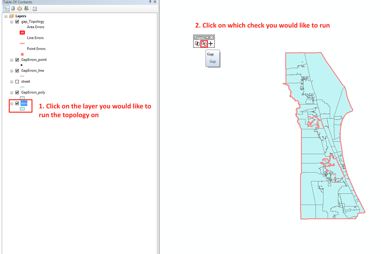
5. Follow the steps in the screenshot!
As I said it is still a work in progress, especially the street dangle check.
Let me know what you think!
Tim
- Mark as New
- Bookmark
- Subscribe
- Mute
- Subscribe to RSS Feed
- Permalink
- Report Inappropriate Content
Heather tested it with 10.4.1, I think this was the highest. I don't see any reason why it wouldn't run in 10.5.
- Mark as New
- Bookmark
- Subscribe
- Mute
- Subscribe to RSS Feed
- Permalink
- Report Inappropriate Content
Hi. I'm new here. Getting over many hurdles of learning ArcGIS and incorporating Python. So much better once I added pandas and a few other modules to the old barebones version of (2.7) Python that came with the 10.3 release. (Was on 10.1 but was forced to upgrade to 10.3 when geocoding stopped working.)
I love to test new features, but always want to see the source code first. Is there a central github or other repository where people put their code? I see above some links to individual's blogs. Is there also a central repository?
- Mark as New
- Bookmark
- Subscribe
- Mute
- Subscribe to RSS Feed
- Permalink
- Report Inappropriate Content
That is a good idea, I will have to do that.
- Mark as New
- Bookmark
- Subscribe
- Mute
- Subscribe to RSS Feed
- Permalink
- Report Inappropriate Content
Tim, any way you could post or send me the source code (if you're not ready to post)? I would love to be able to explain it in detail to my group on Wednesday. heatherw@sanmiguelcountyco.gov
Thanks, and thanks again for developing and sharing such a great tool!
- Mark as New
- Bookmark
- Subscribe
- Mute
- Subscribe to RSS Feed
- Permalink
- Report Inappropriate Content
Heather... did you already look https://community.esri.com/docs/DOC-9983-topology-check-python-addin you asked a couple weeks ago so you may have found it by now.
- Mark as New
- Bookmark
- Subscribe
- Mute
- Subscribe to RSS Feed
- Permalink
- Report Inappropriate Content
Thanks, Rebecca. Tim sent me the Python code so I could explain it to our group.
- Mark as New
- Bookmark
- Subscribe
- Mute
- Subscribe to RSS Feed
- Permalink
- Report Inappropriate Content
If anybody else wants the code, just let me know in this thread.
- Mark as New
- Bookmark
- Subscribe
- Mute
- Subscribe to RSS Feed
- Permalink
- Report Inappropriate Content
Always happy to look at Python code.
- Mark as New
- Bookmark
- Subscribe
- Mute
- Subscribe to RSS Feed
- Permalink
- Report Inappropriate Content
Heather Widlund I made an updated version with dangle tolerance https://community.esri.com/docs/DOC-9983-topology-check-python-addin
Check it out 
- Mark as New
- Bookmark
- Subscribe
- Mute
- Subscribe to RSS Feed
- Permalink
- Report Inappropriate Content
Thank you - I will pass it on!