- Home
- :
- All Communities
- :
- Products
- :
- Data Management
- :
- Data Management Questions
- :
- ArcMap - Updating Autocad Geometry
- Subscribe to RSS Feed
- Mark Topic as New
- Mark Topic as Read
- Float this Topic for Current User
- Bookmark
- Subscribe
- Mute
- Printer Friendly Page
ArcMap - Updating Autocad Geometry
- Mark as New
- Bookmark
- Subscribe
- Mute
- Subscribe to RSS Feed
- Permalink
- Report Inappropriate Content
Hi,
Brand new user. Was looking for an ArcMap forum. Hopefully I can ask my question here. If not, let me know.
Been going through esri tutorials and I have a question: If I regularly update geometry in Autocad such as roads, underground lines, buildings, etc, and then import the updated Autocad geometry, will Arcmap's previous geodata from previous imports be overwritten or removed in favor of the new import?
https://community.esri.com/groups/cadgis-data-integration?sr=search&searchId=e3515a6a-659f-4f23-90cb... https://community.esri.com/groups/arcgis-for-autocad?sr=search&searchId=8ea19f0c-85cc-4ea3-ba19-fd63...
- Mark as New
- Bookmark
- Subscribe
- Mute
- Subscribe to RSS Feed
- Permalink
- Report Inappropriate Content
If you are using CAD to Geodatabase—Help | ArcGIS for Desktop to import the CAD data to a Geodatabase, then the corresponding Feature Classes in the Geodatabase will get overwritten by the new outputs if you enable Overwrite the outputs of geoprocessing operations in Geoprocessing Options (and the output dataset names are also same).
Think Location
- Mark as New
- Bookmark
- Subscribe
- Mute
- Subscribe to RSS Feed
- Permalink
- Report Inappropriate Content
Peter,
ArcMap is too broad of a place for a forum topic. That's why so many topics have been broken down like you sited. This topic would likely be best in the CAD/GIS Data Integration group (as you mentioned). (or maybe even New to GIS).
As Jayanta mentioned, CAD to Geodatabase tool would work. In ArcGIS Pro, when I went to export my CAD layer to a layer of the same name, I get this minor error (the triangle and then the message that says the feature class already exists):
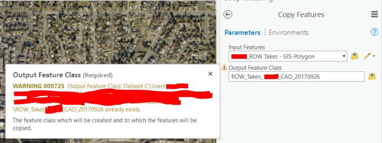
When I went ahead and made the layer, there was no warning - it just overwrote what was once there.
- Mark as New
- Bookmark
- Subscribe
- Mute
- Subscribe to RSS Feed
- Permalink
- Report Inappropriate Content
Thank you guys. I'm experimenting with your suggestions today. Thank you for your time. Hopefully I interpret it all correctly and get what I need.