Turn on suggestions
Auto-suggest helps you quickly narrow down your search results by suggesting possible matches as you type.
Cancel
- Home
- :
- All Communities
- :
- Industries
- :
- State & Local Government
- :
- State & Local Government Questions
- :
- Road Class Domain: Data Dictionary vs Fire Station...
Options
- Subscribe to RSS Feed
- Mark Topic as New
- Mark Topic as Read
- Float this Topic for Current User
- Bookmark
- Subscribe
- Mute
- Printer Friendly Page
Road Class Domain: Data Dictionary vs Fire Station Wall Map
Subscribe
758
3
05-30-2013 11:49 AM
05-30-2013
11:49 AM
- Mark as New
- Bookmark
- Subscribe
- Mute
- Subscribe to RSS Feed
- Permalink
- Report Inappropriate Content
In loading my data into the LGIM I used the data dictionary to help me determine the Road Classes (converting from MTFCC, CFCC and ODOT FCC). In the dictionary it seems that the LGIM 'Collector' designation is lower than both 'Arterials' so that is what I went by. Most of the Local Gov Map templates I have used previously, lump Major and Minor Arterial and Collector all together in similar symbology, so I have not noticed any problems.
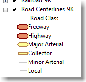
However, in the Fire Station Wall map the symbolism has this order (see Road Centerlines_9K):
Freeway
Highway
Major Arterial
Collector
Minor Arterial
Local, etc.
And the difference in Collector and Minor Arterial shows up very distinctly in the map. So now I either need to reassign my road segments to different domains or change the Fire Station map symbology. But I want to know which hierarchy is correct since it will be used in future LGIM templates and I only want to correct this once.
The Local Gov data dictionary has the classes listed in this order:
Freeway
Highway
Major Arterial
Minor Arterial
Collector
Local, etc.
Thanks for any advice,
Leitha
3 Replies
06-13-2013
09:19 AM
- Mark as New
- Bookmark
- Subscribe
- Mute
- Subscribe to RSS Feed
- Permalink
- Report Inappropriate Content
The order of the road class in the map supports cartographic display and does not imply a hierarchy. Its designed to support the map. The domain in the information model closely matches the functional classification of roads as adapted from the FHWA.
06-13-2013
10:56 AM
- Mark as New
- Bookmark
- Subscribe
- Mute
- Subscribe to RSS Feed
- Permalink
- Report Inappropriate Content
Scott,
Thanks for your response. My road data is heavy in Minor Arterial and Collector designations and the Fire Map's symbology makes a big difference. I don't understand your statement that the map's symbology "does not imply a hierarchy". Clearly the map symbology does in fact imply this:
[ATTACH=CONFIG]25248[/ATTACH]
But it does not reflect the same hierarchy as is implied in the LG Data Dictionary.
If I can read between the lines in your response, I think you are saying that the Local Gov Model, following the FHWA, sets "Collectors" lower than both "Major and Minor Arterial". If this is the case, then I will adjust the symbology in the Fire Map to reflect this and will not make changes to my data.
If I am correct, perhaps the Fire Map could be updated with symbology that is more reflective of the underlying data structure? Just a heads up for anyone using this map template.
Cheers,
Leitha
07-12-2013
06:38 AM
- Mark as New
- Bookmark
- Subscribe
- Mute
- Subscribe to RSS Feed
- Permalink
- Report Inappropriate Content
This link to FHWA road classification might help you. I too am working to classify our road features for use in the LGIM.
http://www.fhwa.dot.gov/planning/processes/statewide/related/functional_classification/fc02.cfm
Has anyone found an ESRI style set for MTFCC codes? That would be helpful.
http://www.fhwa.dot.gov/planning/processes/statewide/related/functional_classification/fc02.cfm
Has anyone found an ESRI style set for MTFCC codes? That would be helpful.