Flood Impact Analysis solution
- Subscribe to RSS Feed
- Mark as New
- Mark as Read
- Bookmark
- Subscribe
- Printer Friendly Page
- Report Inappropriate Content
What is the Flood Impact Analysis solution?
The Flood Impact Analysis solution can be used to develop flooding scenarios and visualize the impact on the existing landscape. It leverages flood depth data to analyze the impact of flood events on critical assets such as buildings, bridges, low water crossings and roads. It also can be used to create compelling 3D visualizations that make it easier to understand and communicate the real impact of flooding events.

Benefits
The flood impact analysis solution template leverages flood depth data to analyze the impact of flood events on critical assets such as buildings, bridges, low water crossings and roads. You can:
- Define flood impact areas at each flood stage
- Determine what assets will be impacted and by how much
- Communicate the results of the analysis to community stakeholders
- create compelling 3D visualizations that make it easier to understand and communicate the real impact of flooding events.
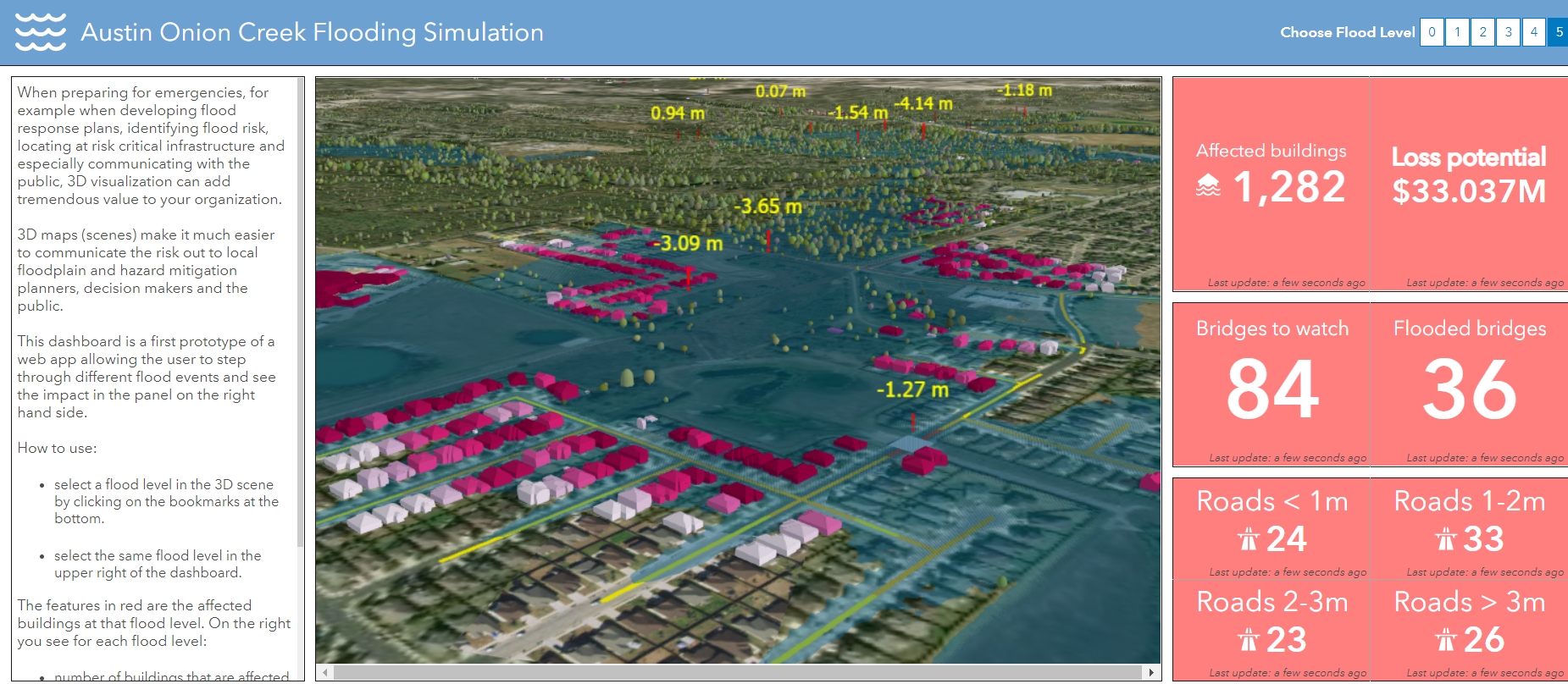
Example: Operations Dashboard for ArcGIS
Get started with the Flood Impact Analysis solution
- Deploy the Flood Impact Analysis Pro project.
- Open the FloodImpactAnalysis.aprx in ArcGIS Pro
System requirements
The following software is required:
- ArcGIS Pro 2.4 or higher (Advanced)
- ArcGIS 3D Analyst extension
- ArcGIS Spatial Analyst extension
Feedback
It would be helpful for us to know:
- how these workflows and apps will benefit your organization
- how the workflows and apps can be improved
- any bugs or other issues.
For comments, questions, bug reports, new requirements: email gvanmaren@esri.com
You must be a registered user to add a comment. If you've already registered, sign in. Otherwise, register and sign in.