- Home
- :
- All Communities
- :
- Products
- :
- 3D
- :
- 3D Mapping Questions
- :
- Why is my tile elevation layer incomplete?
- Subscribe to RSS Feed
- Mark Topic as New
- Mark Topic as Read
- Float this Topic for Current User
- Bookmark
- Subscribe
- Mute
- Printer Friendly Page
Why is my tile elevation layer incomplete?
- Mark as New
- Bookmark
- Subscribe
- Mute
- Subscribe to RSS Feed
- Permalink
- Report Inappropriate Content
Rather than using the default Terrain3D as a ground layer for a Web Scene I would like to use some higher resolution data I have. The area of interest is irregularly shaped and the DEM resolution is 1.5 meters. I have been using the following workflow to prepare my tile layers:
Tool > Manage Tile Cache: Used to create a new tile cache. I tried using a feature class to define the AOI but this resulted in a blank output. Instead I left the AOI as default and traced around the feature class I wanted to use. The output looked good
Tool> Export Tile Cache: I used this to export the tile cache as a tile package layer.
Tool> Share Package: Although the output was under 1GB I still used this to upload to ArcGIS online because, well, why not.
In AGOL I move the tpk to a folder and published it. I then started a new scene (tried both local and global) and the result is that my new elevation layer works.... but gets cut off abruptly to the North. See the image below:
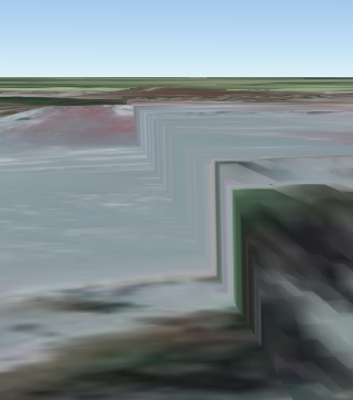
The extent is set correctly in AGOL but the auto-generated thumbnail is for the incorrect extent. I wanted to try it in ArcPro too to see if the elevation layer showed the same behaviour but instead Pro displayed a hellish minecraft inspired interpretation of the AOI. I have no screen shots of the ArcPro attempt as I deemed them too disturbing for general consumption.
- Mark as New
- Bookmark
- Subscribe
- Mute
- Subscribe to RSS Feed
- Permalink
- Report Inappropriate Content
Are you using the elevation layer along with the default elevation service? If you wanted to create a scene that uses your elevation to the same extent envelope you can create a local scene in Pro to the exact elevation extent and clip the extent to that and if you wanted to you can add the elevation layer in SV instead of in Pro.
- Mark as New
- Bookmark
- Subscribe
- Mute
- Subscribe to RSS Feed
- Permalink
- Report Inappropriate Content
Thanks Russell, I am using the elevation along with the default (I was under the impression from the docs that that was a necessity).
Each map or scene contains a predefined elevation surface called Ground that cannot be removed. The default elevation source for this surface is a cached elevation image service, World DTM. If you are not connected to the Internet, you will not have access to this service and the ground elevation will be 0. You can optionally add a local elevation source to the ground elevation surface.
Taken from Elevation surfaces—Properties of maps | ArcGIS Desktop
I read the above as meaning you can add a source but not remove the default ground. Removing the original ground elevation surface plays havoc with pro and AGOL.
I'm also not sure what you mean by SV?
I've tried clipping the extent to a rectangle rather than the complex polygon and get slightly better results but it seems to be a rendering issue in AGOL.
- Mark as New
- Bookmark
- Subscribe
- Mute
- Subscribe to RSS Feed
- Permalink
- Report Inappropriate Content
Sorry, SV(Scene Viewer)
You can remove the default elevation layer in Pro, under the scene settings, click the X

Add Elevation source - pick the elevation layer item you published from the TPK.. or if you want to use this all local you can use DTM data.
So if you are using the 2 different elevation sources because they are at different resolutions and sources you can see these sharp edges where one elevation ends and the other begins when there are sharp differences.
- Mark as New
- Bookmark
- Subscribe
- Mute
- Subscribe to RSS Feed
- Permalink
- Report Inappropriate Content
Thanks Russell. SV! Doh 
I have tried removing the default ground layer and it sends everything haywire in AGOL and pro. Pan and zoom behaves erratically, and it often looks like there are two "worlds" with sections missing from the upper one. As shown in the screen shot below (in fact this one goes right through to space):
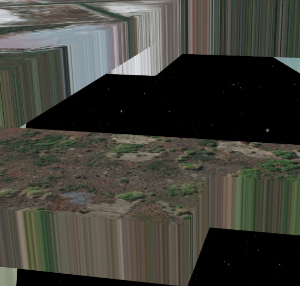
The sharp edges that exist I would expect given I am using two different ground layers. However, the sharp edges do not exist at the maximum extent of my custom elevation source. Instead they appear randomly. If it were only at the edges this would be expeted behaviour but as it isn't I suspect something else is wrong.
Cheers,
Oliver
- Mark as New
- Bookmark
- Subscribe
- Mute
- Subscribe to RSS Feed
- Permalink
- Report Inappropriate Content
If you can share your tpk and elevation layer with me I can take a look. create a group and invite russell_jsapi into it.
Thanks!
- Mark as New
- Bookmark
- Subscribe
- Mute
- Subscribe to RSS Feed
- Permalink
- Report Inappropriate Content
Thanks Russell,
I'm afraid I can't do that (data licensing etc) but I'll try and recreate with a different dataset so you can check it out.
I'm now having similar problems with a raster image layer and it would appear AGOL is not publishing all the tiles for every zoom level. This may be what is wrong with the elevation layer.

For example 1:1128 is only 10% complete. I have plenty of space on AGOL and have tried republishing. Any ideas?
Cheers and I'll let you know when the other dataset is up for a demo.
- Mark as New
- Bookmark
- Subscribe
- Mute
- Subscribe to RSS Feed
- Permalink
- Report Inappropriate Content
The tiles could still be being generated, did you publish them by uploading a TPK or publishing a tile layer from Pro or ArcMap?
- Mark as New
- Bookmark
- Subscribe
- Mute
- Subscribe to RSS Feed
- Permalink
- Report Inappropriate Content
I've tried both. They've definitely finished generating. However, I've just discovered what might be the problem. Saving the map document! It looks from the raster imagery tile cache that regardless of what extent I set in the tool it will be over-ridden by the extent the map document is saved at. The most recent tpk is >5x bigger than the last one. The same may be true of the elevation layer as I had odd behaviour relating to extents. I'll keep you posted Russell.
Tiles for the raster image are all published now and 100% across the board.
Absolutely works in scene viewer which is great news.
I'll apply the same to the elevation web layer now (save the mxd at the required extent) but that takes much longer to process.
Cheers Russell,
Oliver