- Home
- :
- All Communities
- :
- Industries
- :
- Telecommunications
- :
- Announcements
- :
- TelUC Bits & Bytes Newsletter - February 2024
TelUC Bits & Bytes Newsletter - February 2024
- Subscribe to RSS Feed
- Mark as New
- Mark as Read
- Bookmark
- Subscribe
- Printer Friendly Page
- Report Inappropriate Content
News & Updates
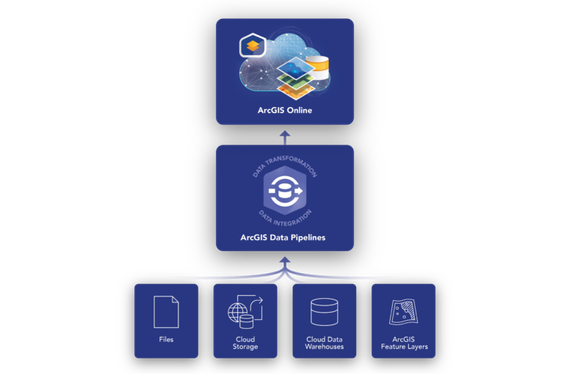
Data Pipelines Officially Released
Effective geospatial analysis relies heavily on accessing, integrating, and preparing data from a variety of sources. This can be a time consuming and tedious task, made even more complex when the source data updates on a regular basis. ArcGIS Data Pipelines provides a comprehensive solution to this challenge, and we are excited to announce that it is officially out of beta and available for general use in ArcGIS Online. Continue reading.
Introducing the Calculate Composite Index Tool in ArcGIS Online Map Viewer
With the February 2024 release of ArcGIS Online, you can now use the Calculate Composite Index tool in analysis in Map Viewer. The Calculate Composite Index tool combines multiple numeric variables to create a single index. Composite indices are powerful tools that can help make potentially life changing decisions in allocating resources. With the new Calculate Composite Index tool in ArcGIS Online, it’s easier than ever before to make your own. We highly encourage you to take the time to understand how all of the decisions you make in the tool can impact your results. Learn more.
Data Center Monitoring with ArcGIS
Using ArcGIS for data center monitoring provides significant business value by enabling telecom companies to effectively manage and monitor their data centers. ArcGIS allows telecom companies to visualize and analyze data related to their data centers in a spatial context. This spatial perspective helps in identifying potential issues, optimizing resource allocation, and improving overall operational efficiency. By integrating real-time data from various sources, such as sensors, network devices, and environmental factors, ArcGIS enables telecom companies to monitor critical parameters like temperature, humidity, power consumption, and network connectivity. This proactive monitoring helps in identifying and addressing potential issues before they escalate, minimizing downtime and ensuring uninterrupted service delivery. Additionally, ArcGIS can provide valuable insights into the spatial distribution of data centers, helping telecom companies in strategic decision-making, such as site selection, capacity planning, and network optimization. Overall, the use of ArcGIS for data center monitoring enhances operational efficiency, reduces costs, and improves the quality of service, leading to a competitive advantage in the telecom industry. If you're interested in learning more about data center monitoring and real-time visualization and analysis, check out the demo below and take a look at what's to come at this year's Esri DevSummit: https://www.esri.com/arcgis-blog/products/arcgis-velocity/announcements/real-time-gis-guide-to-esri-...
Product Updates:
What's New in ArcGIS Online (February 2024)
What's new in ArcGIS Field Maps (February 2024)
What's new in ArcGIS Survey123 (February 2024)
What's new in ArcGIS Workflow Manager (February 2024)
Discover What's New In ArcGIS Dashboards (February 2024)
What’s New in Scene Viewer (February 2024)
What's New in Instant Apps (February 2024)
What's New in ArcGIS Image for ArcGIS Online (February 2024)
What's New in ArcGIS Maps SDK for JavaScript (4.29)
Recent TGI5s
TGI5 - Episode 098 - Spatial Analysis Tools in Online Map Viewer
Meetups & Events
Esri Developer Summit - Event Meetup
Tuesday, March 12, 2024 - Calling all developers in telecom! We'll once again be gathering the community to sit down together at lunch on the first day of the Esri Developer Summit. Follow the event page for more information.
TGI60 - ArcGIS Developers - Virtual Meetup
Tuesday, March 19, 2024 - Join the Esri Telecom team for an update on what's new in ArcGIS Developers. Registration is open.
Esri Denver Mile High Regional Meetup - Denver - In-Person
Thursday, March 28, 2024 - Want to get together will fellow GIS Professionals in the Denver area? The Esri Telecom Team will be hosting a meetup for the Telecom User Community out of the Esri Denver RO. Let us know what topics you would like to discuss and be on the look out for the registration email coming soon.
Telecom Insights
Understanding Rural Broadband Deployment: The Role of ArcGIS in Navigating Potential Impacts
Our society stands on the brink of an unbelievable transformation, a once in a lifetime effort if you will, as we embark on the journey to expand broadband networks deeper than ever into the rural heartlands of America. This undertaking, fueled by substantial investments and the goal of achieving global connectivity, emphasizes the critical need for thorough planning, broadband deployment efforts, and ongoing network operations or maintenance. To connect society completely, the telecom industry needs a comprehensive solution. Continue reading.
MWC Partner Interview: Esri
Live from MWC Barcelona, Director Randall Rene discusses how its GIS technology helps with network planning.
Step Telecoms Increases Efficiency with Asset Management Using ArcGIS
Step Telecoms is an Irish telecommunications company primarily serving the data center industry. The company currently owns and manages over 250,000 meters of duct network and has installed and maintained over 500,000 meters of fiber-optic cable linking key data center sites in Dublin. With network reliability and connectivity being the primary concerns of their clients, Step Telecoms needed a more efficient way to visualize and manage their network. Continue reading.
For more insights, be sure to sign up for the Telecom News newsletter at esri.com/telecom.
Previous Bits & Bytes:
- TelUC Bits & Bytes Newsletter - March 2023
- TelUC Bits & Bytes Newsletter - April 2023
- TelUC Bits & Bytes Newsletter - May 2023
- TelUC Bits & Bytes Newsletter - June 2023
- TelUC Bits & Bytes Newsletter - July 2023
- TelUC Bits & Bytes Newsletter - August 2023
- TelUC Bits & Bytes Newsletter - September 2023
- TelUC Bits & Bytes Newsletter - October 2023
- TelUC Bits & Bytes Newsletter - November 2023
- TelUC Bits & Bytes Newsletter - December 2023
- TelUC Bits & Bytes Newsletter - January 2024
You must be a registered user to add a comment. If you've already registered, sign in. Otherwise, register and sign in.


