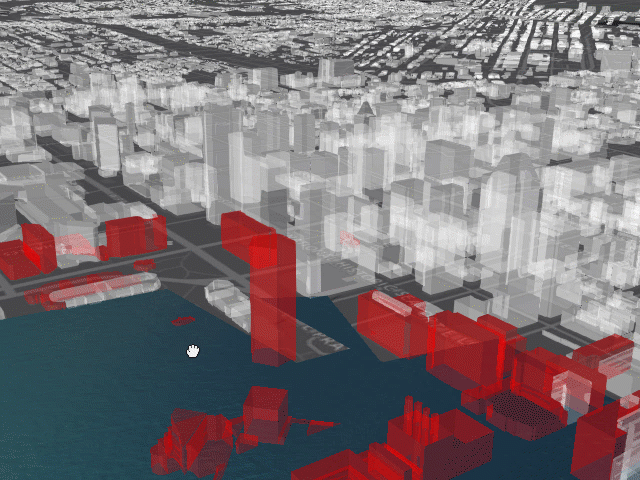
Realistic Waters Effects in JavaScript Web Apps

3187
16
07-03-2017 07:05 PM
RichieCarmichael
Esri Contributor
6 16 3,187

Experimental Water Effects

At last year's Developer SummitJesse van den Kieboom demonstrated how realistic water effects can be applied to a JavaScript based web application (see slides, demo and source).  The Prototype Lab modified Jesse's code to work with coastal inundation areas hosted in an AGOL feature service.  This sample is based on version 4.3 of the ArcGIS API for JavaScript and three.js.

Click here for the live application.

Click here for the source code.

16 Comments
IsmaelChivite
Esri Notable Contributor

Thanks for sharing Richie!  The links to the live app and source code are reversed. The live  app links to the source code and the source link take you to the live app.

RichieCarmichael
Esri Contributor

Posting corrected. Thanks Ismael!

VirNaidoo
New Contributor

Hi, Ismael:

   The code i have downloaded ,but the html file i can't open it.Would you mind to tell me how to deploy it ??

   Thanks advance.

Vir Naidoo

RichieCarmichael
Esri Contributor

Hi Vir Naidoo‌,

The downloaded html/js/css files need to be hosted on a web server like IIS. Below is a link to a short youTube video describing how to host web page files on a local IIS server on Windows 10.

How To Setup Website Hosting On Windows 10 Using IIS

Hope this helps!

VirNaidoo
New Contributor

Dear Richie :

The video is good helpful.The website has opened successful!Thank you ~

VirNaidoo
New Contributor

Dear Richie :


I see the code of the demo's html and JS files,and want to know whether the render is based on sceneLayer? I have been always think it is based on featureLayer. Could you please tell me ??

RichieCarmichael
Esri Contributor

Hi Vir Naidoo‌,

Geometry for the ocean, or specifically the Patapsco River in Baltimore, is sourced from a feature service. This geometry is rendered using an external renderer.

VirNaidoo
New Contributor

Hi Richie Carmichael ,

I really want to know why use "esri/geometry/Extent"and"esri/views/3d/layers/graphics/earcut/earcut",? forgive me, i'm a freshman on this.


RichieCarmichael
Esri Contributor

Hi Vir Naidoo‌,

No need to apologize. You can find the API reference and developer samples for the ArcGIS API for JavaScript here. Earcut is an undocumented class used for polygon tessellation.

VirNaidoo
New Contributor

HiRichie Carmichael ,

I just replace the URL of featureLayer, in my scene the featureLayer was broken,it seems been cut by the code, just like the picture in the below. could you please tell me what cause that?? thanks advance.

Here is my featureLayer service:    https://trail.arcgisonline.cn/arcgis/rest/services/lake/FeatureServer 

RichieCarmichael
Esri Contributor

Hi Vir Naidoo‌,

Very unusual. Perhaps you are reaching a vertex count limitation. Try generalizing the geometry with either the REST API or client-side (see generalize).

jinghan2
New Contributor

hey,I wander weather you can do some external work to make this code simple to use??

RichieCarmichael
Esri Contributor

Hi jing han‌, I agree that to achieve this water affect is fairly complicated. Hopefully future releases of the ArcGIS API for JavaScript will make this easier.  In the meantime perhaps CityEngine can provide a realistic representation of your data.

VirNaidoo
New Contributor

Hi Richie Carmichael ,

I just achieved it with custom elevation layer,and now i have a project include 2D and 3D switch function, and i wonder how  to put the realistic water in to my project. I have tried so many time and failed ,could you please show me how to achieve it??? 

RichieCarmichael
Esri Contributor

Hi Vir Naidoo‌, I may not be able provide the timely assistance you need. As such, may I suggest you contact Esri Support.

SaschaBrunnerCH
Esri Contributor