- Home
- :
- All Communities
- :
- Products
- :
- ArcGIS Business Analyst
- :
- ArcGIS Business Analyst Questions
- :
- Thematic maps from an imported file on business an...
- Subscribe to RSS Feed
- Mark Topic as New
- Mark Topic as Read
- Float this Topic for Current User
- Bookmark
- Subscribe
- Mute
- Printer Friendly Page
Thematic maps from an imported file on business analyst online
- Mark as New
- Bookmark
- Subscribe
- Mute
- Subscribe to RSS Feed
- Permalink
- Report Inappropriate Content
Hi there,
I have a simple excel spreadsheet with 2 columns: zip code, items sold.
Is there a way to produce a thematic map on business analyst online (BAO) with the sales as the measure?
I can see the map with the geographic boundaries but they are all the same colour.
I also know how to create thematic maps with existing variables in BAO but not with an imported file.
Is this doable?
A
- Mark as New
- Bookmark
- Subscribe
- Mute
- Subscribe to RSS Feed
- Permalink
- Report Inappropriate Content
Hello Axel,
Thanks for reaching out to the Business Analyst team. I would like to inform you that we are considering this workflow for a future release but we don't have a specific timeline yet. In the meantime, I hope the following workaround works for you:
1. Go to Add Data > Import File > Browse and Import your file
2. Select the Geographic boundaries option > match your boundary fields (eg. Zip codes)
3. Click Next > Save the layer > click Organize Sites.
Note: You will see the imported layer is saved under Geographies (Sites) now. This layer is saved in your project feature service. Notice the name of my project is "Thematic Demo".

4. Un-check the check box next to the layer to remove it from the map.
5. Go to Add Data > Custom Data Setup > Start Setup
6. Choose Layer > Browse for a layer > Click on My Groups tab and sort by Recent.
Note: You'll see your project feature services listed here. And you can see "Thematic Demo Layers" is the feature services that contains the imported file.
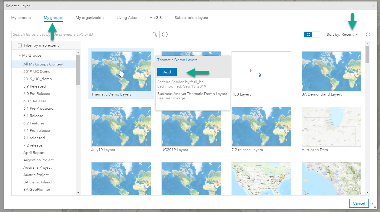
7. Hover over that item and click Add > select the imported layer.

8. Click Setup Custom Data > Drag and drop the variables you want to map to the right.

Note: You can learn more about Custom Data here: Custom Data Setup—Business Analyst Web App | ArcGIS
9. Click Save and you will see the following options > Click Color-Coded Maps.

10. Select the desired variable to and you can create a thematic map from your imported layers as follows:

Note: You can use your custom data in any supported workflows by browsing to it in the data browser (My Data).

I hope this is helpful,
Best regards,
Fasil T.
Business Analyst Team
- Mark as New
- Bookmark
- Subscribe
- Mute
- Subscribe to RSS Feed
- Permalink
- Report Inappropriate Content
Yes! Thank you very helpful.
It's such a common and useful action that in my view would make sense to make it part of a formal workflow.
Thanks again!
- Mark as New
- Bookmark
- Subscribe
- Mute
- Subscribe to RSS Feed
- Permalink
- Report Inappropriate Content
Hello Axel,
I just wanted to inform you that this workflow is implemented in the December release of Business Analyst web App.
Go to: Add Data > Custom Data Setup > Start Setup > Select a file to import > select geographic boundaries > set up your variables > use your data in all supported workflows from the data browser.
Here is the help doc: Custom Data Setup—Business Analyst Web App | Documentation
With this new feature, you can bring in your tabular data and join it to a geographic boundaries so that you can use your own data in all analysis and reporting workflows.
Best regards,
Fasil T
- Mark as New
- Bookmark
- Subscribe
- Mute
- Subscribe to RSS Feed
- Permalink
- Report Inappropriate Content
Thank you so much for closing the lop on this.
A