- Home
- :
- All Communities
- :
- Products
- :
- ArcGIS Collector
- :
- ArcGIS Collector Questions
- :
- Re: Is it possible to create fields in FGDB that w...
- Subscribe to RSS Feed
- Mark Topic as New
- Mark Topic as Read
- Float this Topic for Current User
- Bookmark
- Subscribe
- Mute
- Printer Friendly Page
Is it possible to create fields in FGDB that will automatically populate with lat/long when feature is collected?
- Mark as New
- Bookmark
- Subscribe
- Mute
- Subscribe to RSS Feed
- Permalink
- Report Inappropriate Content
Wondering if there is a field type that can be set to automatically populate a field with lat and a field with long when a feature is collected using Collector.
Also would like to create a field that creates consecutively numbered stations as they are collected. Looking to have the field essentially be previous station # +1 without having to manually input the number.
Appreciate any thoughts.
thanks
- Mark as New
- Bookmark
- Subscribe
- Mute
- Subscribe to RSS Feed
- Permalink
- Report Inappropriate Content
Dave, if you can share the geodatabase I'll take a look. I'm sure Miaogeng can help as well but he is the Esri Rep for all things Collector on the GeoNet forum so it might take him longer. Perhaps upload the FGDB to AGOL and share it publicly. If you don't want to or can't share it publicly create a new group, share it to that group, and add me as a member. I'm guessing it is a projection issue but unsure unless I see it.
- Mark as New
- Bookmark
- Subscribe
- Mute
- Subscribe to RSS Feed
- Permalink
- Report Inappropriate Content
Ben,
Have shared FGDB on AGOL. File is called "Structure Field Trip Stops
<http://hamilton1812.maps.arcgis.com/home/item.html?id=885843205b284eeab79509b6b2aab148>
"
Thanks,
Dave
- Mark as New
- Bookmark
- Subscribe
- Mute
- Subscribe to RSS Feed
- Permalink
- Report Inappropriate Content
Thanks Dave, looking at it now.
- Mark as New
- Bookmark
- Subscribe
- Mute
- Subscribe to RSS Feed
- Permalink
- Report Inappropriate Content
Hey Dave, it appears that the relationship class is causing the Calculate Geometry tool to be inactive. In order to activate the Calculate Geometry tool you have to begin an edit session. Not sure the exact cause and affect here but I was able to calculate the geometry inside of an edit session within ArcMap. Try it on your end.
- Mark as New
- Bookmark
- Subscribe
- Mute
- Subscribe to RSS Feed
- Permalink
- Report Inappropriate Content
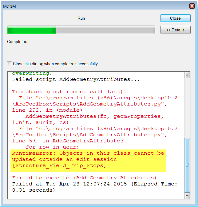
Dave, I tried putting this into a model which would add the fields and calculate geometry. The model returned a RuntimeError: Objects in this class cannot be updated outside an edit session. If you want to use this data structure and automate the process I believe you will have to write the code in Python, I think you can activate an edit session in Python (someone please correct me if I am wrong). You may find some help by posting a separate discussion in the Python Group to ask for a script to add fields, calculate geometry, and whatever else you might need. Nice working with you and good luck 
- Mark as New
- Bookmark
- Subscribe
- Mute
- Subscribe to RSS Feed
- Permalink
- Report Inappropriate Content
Hello Dave,
Here is the documentation with step by step instructions on 'Calculate Geometry'.
Hopefully that helps!
- Mark as New
- Bookmark
- Subscribe
- Mute
- Subscribe to RSS Feed
- Permalink
- Report Inappropriate Content
Try clicking CTRL + SHIFT + G after clicking the field.
- Mark as New
- Bookmark
- Subscribe
- Mute
- Subscribe to RSS Feed
- Permalink
- Report Inappropriate Content
Sol,
Seems that in order to calculate geometry on the FGDB data requires that
you be in edit mode for the dataset.
From ArcGIS help referenced above
"Start an edit session
<http://resources.arcgis.com/en/help/main/10.1/01m6/01m60000005p000000.htm>.
1.
You can make calculations without being in an editing session; however,
in that case, there is no way to undo the results."
This is not appear to be completely true for a FGDB. If you are in an
editing session for the FGDB data, Calculate Geometry is available. If you
are not in an edit session, it is grayed out. Shapefiles have Calculate
Geometry available if you are or are not in an edit session for the data.
Thanks, learned something new.
- Mark as New
- Bookmark
- Subscribe
- Mute
- Subscribe to RSS Feed
- Permalink
- Report Inappropriate Content
Dave, if you disable the relationship class in your geodatabase you can calculate geometry outside of an edit session, I tested this out. The relationship class is your limitation in this scenario.
- Mark as New
- Bookmark
- Subscribe
- Mute
- Subscribe to RSS Feed
- Permalink
- Report Inappropriate Content
Thanks Ben
Had not thought about that.
Dave
- « Previous
-
- 1
- 2
- Next »
- « Previous
-
- 1
- 2
- Next »