- Home
- :
- All Communities
- :
- Products
- :
- ArcGIS Enterprise
- :
- ArcGIS Enterprise Ideas
- :
- Hide sublayers from a published map service
- Subscribe to RSS Feed
- Mark as New
- Mark as Read
- Bookmark
- Follow this Idea
- Printer Friendly Page
- Report Inappropriate Content
- Mark as New
- Bookmark
- Subscribe
- Mute
- Subscribe to RSS Feed
- Permalink
- Report Inappropriate Content
Hello,
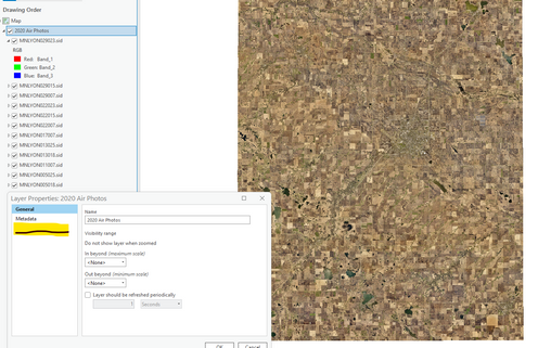
Please consider allowing map publishers a way to hide the layer names within a group. For example, our 2020 air photo service includes 13 individual MrSid files. I want the map service to only list "2020 Air Photos" and not "MrSid1, MrSid2, etc."
I realize that we could combine all the tiles into a single tiff layer, or I purchase image analyst extension. But either of those seem to be overkill.
Figure 1. The layer group should include the option to "Hide Sublayer Names from the Table of Contents".
- Mark as Read
- Mark as New
- Bookmark
- Permalink
- Report Inappropriate Content
Hi,
The image you provided appears to be from ArcMap. ArcMap and ArcGIS Pro are full featured Desktop GIS tools designed to give the user full access to datasets. If your users don't expand the group the sublayers will remain 'hidden' but I doubt that is the functionality you want.
We use the Web AppBuilder (WAB) to publish many map viewers. In the WAB it is possible to suppress the sub-layers in the legend widget. Would a WAB app be a suitable replacement for what you are trying to accomplish?
Bernie.
- Mark as Read
- Mark as New
- Bookmark
- Permalink
- Report Inappropriate Content
just to make sure I understand:
- you don't want to see the sublayers inside the group layer
- that also means that your end users would not see any option toggle visibility of those sub layer
is that correct?
Thanks
- Mark as Read
- Mark as New
- Bookmark
- Permalink
- Report Inappropriate Content
Bernie and Tanu,
I should clarify that my ultimate goal is to use ArcGIS Server to make a Map Service that does not list any of the sublayers. Here another screenshot from a neighboring county. Obviously the air photo map service is important, but any end users dont need to know which MrSID files are included in the 2020_Aerial Map Service.
I could hide the individual MrSID layer names within the Web Application Builder and hope that desktop users don't expand the layer, but I prefer not even acknowledge the sublayers in the service within ArcGIS Server.
Figure 1: The Map Service shows all of the MrSID names that are used in a map (Not Desired)
Figure 2: This 3rd party map service hides all of the MrSID file names that are used in a map (Desired)
I hope that clarifies my needs.
Thank You
- Mark as Read
- Mark as New
- Bookmark
- Permalink
- Report Inappropriate Content
I don't do much work with imagery but I am quite certain if you create a raster tile cache of your imagery you will get two benefits:
- your images will display faster
- the individual image file names will not be available.
Have a look at our imagery basemap. We use satellite imagery for the smaller scales and air photos for the larger scales. Our imagery basemap covers approximately 72,000 km2 - https://geonb.snb.ca/arcgis/rest/services/GeoNB_Basemap_Imagery/MapServer.
If you don't want to invest the time building a raster tile cache I suspect there may be options when you build your mosaic dataset to hide the individual image file names. Ask Esri support for some guidance.
Good luck,
Bernie.
Good luck,
- Mark as Read
- Mark as New
- Bookmark
- Permalink
- Report Inappropriate Content
Thanks @LyonMNGIS. I wanted to know your use cases and workflow to make things better in some other context.
Unfortunately, we currently don't have any good solution for what you ask.... I hope some of the workarounds that other folks suggested might work for you....
I do appreciate your time and effort to share your use case and ideas.
You must be a registered user to add a comment. If you've already registered, sign in. Otherwise, register and sign in.


