- Home
- :
- All Communities
- :
- Products
- :
- ArcGIS GeoEvent Server
- :
- ArcGIS GeoEvent Server Blog
- :
- Using GeoEvent to do Proximity Alerts
Using GeoEvent to do Proximity Alerts
- Subscribe to RSS Feed
- Mark as New
- Mark as Read
- Bookmark
- Subscribe
- Printer Friendly Page
- Report Inappropriate Content
A number of people asked me whether it is possible to use GeoEvent to do proximity alerts or collision avoidance. For example testing whether two airplanes or ships are within a certain distance between each other current positions.
The bad news is there is no Proximity operator in the current GeoEvent 10.3 to help you. The good news you can compose a solution that works even if there are thousands of tracks (of moving objects).
GeoEvent 10.3 added a number of key elements that allow composing a solution to perform this kind of operation. First is a fast in-memory spatial indexing which is a Quadtree-based to help finding an object in space very quickly. Second is Stream Service which is a WebSocket-based that allows push-based real-time streaming output. Third is the GeoFence Synchronization with Stream Service. And the fourth one is the Buffer Creator Processor. Other components are also needed.
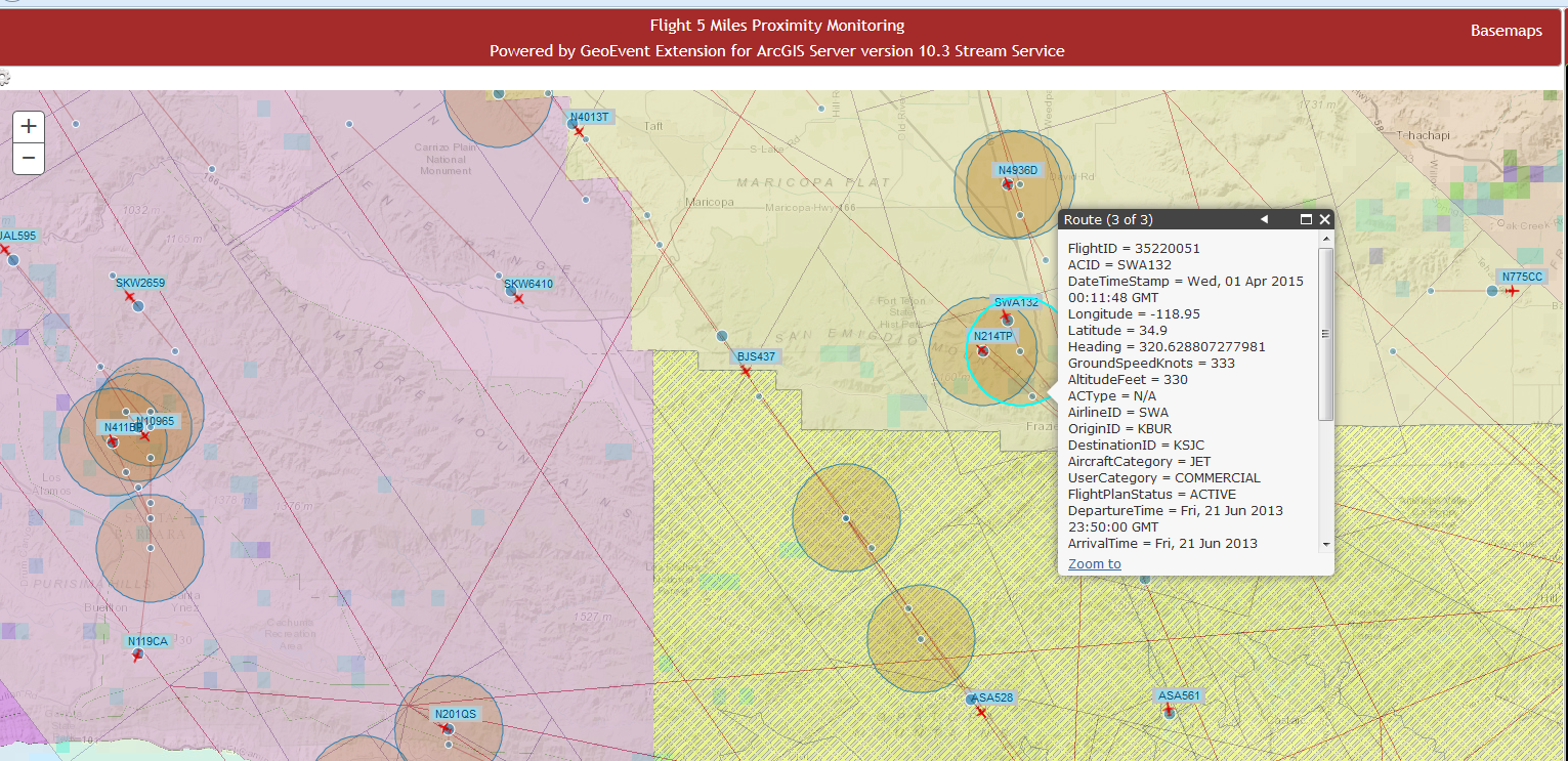
First the input data should be output to a Stream Service as is (i.e. point geometry) to make it available for GeoFence Synchronization then a Synchronize GeoFences needs to be created by connecting to the Stream Service URL outputting from the first step. Once this is done, proximity test processing logic can be set up by first using the Buffer Creator to create a circular geometry for each point. Use GeoTagger to tag the incoming event (the results from the Buffer Creator) with the name of the GeoFence using a Spatial Operator, e.g. "Contains Any". This is pretty much a point-in-polygon test. Please note that there can be more than one GeoFence contained in the resulting field value due to the fact that a buffer polygon can contain more than one point -- which is what we want anyway. If the resulting GeoTag field is not null then trigger the proximity alert by using a filter. The buffers that were GeoTagged can be output to a feature or stream service for displaying on a WebMap in real-time. I tested this with the flight tracking data and obtained results display in a WebMap as shown below:
You must be a registered user to add a comment. If you've already registered, sign in. Otherwise, register and sign in.