- Home
- :
- All Communities
- :
- Products
- :
- ArcGIS Hub
- :
- ArcGIS Hub Questions
- :
- Re: Downloads not in correct projection system
- Subscribe to RSS Feed
- Mark Topic as New
- Mark Topic as Read
- Float this Topic for Current User
- Bookmark
- Subscribe
- Mute
- Printer Friendly Page
Downloads not in correct projection system
- Mark as New
- Bookmark
- Subscribe
- Mute
- Subscribe to RSS Feed
- Permalink
- Report Inappropriate Content
I'm trying to set up an ArcGIS Hub site and I have the ability to download data in local projections enabled. The projection system used for my data is NAD_1983_StatePlane_Indiana_West_FIPS_1302_Feet
WKID: 2966 Authority: EPSG
However, whenever I download anything off the open data site the download is in this projection system:
NAD83_Indiana_West_ftUS_deprecated
Authority: Custom
This is a major problem as this custom projection system is around 2,000 feet off from the correct projection system. Is this a known problem or is there something I need to be doing to make sure my downloads are in the right projection? I have tried uploading layers to AGO using both ArcMap and ArcGIS Pro and both methods give me the same wrong download projection.
- Mark as New
- Bookmark
- Subscribe
- Mute
- Subscribe to RSS Feed
- Permalink
- Report Inappropriate Content
Hi Matt, would you mind sharing a URL to your dataset?
- Mark as New
- Bookmark
- Subscribe
- Mute
- Subscribe to RSS Feed
- Permalink
- Report Inappropriate Content
https://data1-lakeingispro.opendata.arcgis.com/datasets/centerlines
I just posted this dataset this morning as I'm still trying to trouble shoot this. This was a feature class that I exported to a shapefile before uploading to AGO using ArcMap. I've also uploaded feature classes without exporting them to shapefiles first. Both methods have produced the same end result.
- Mark as New
- Bookmark
- Subscribe
- Mute
- Subscribe to RSS Feed
- Permalink
- Report Inappropriate Content
Sorry, I accidentally deleted the layer I sent you the first URL to. Here is a link to an active layer that is still downloading in the wrong projection.
https://data1-lakeingispro.opendata.arcgis.com/datasets/lakecounty-centerlines
- Mark as New
- Bookmark
- Subscribe
- Mute
- Subscribe to RSS Feed
- Permalink
- Report Inappropriate Content
Hi Matt, the Service URL associated with https://data1-lakeingispro.opendata.arcgis.com/datasets/lakecounty-centerlinestakes me to https://services5.arcgis.com/8CXRnvSfSpwdf0R6/ArcGIS/rest/services/LakeCounty_Centerlines/FeatureSer.... I can see there that the ArcGIS hosted service layer has WKID 2245, rather than 2966 as you note in your initial comment. WKID 2245 is "NAD83_Indiana_West_ftUS_deprecated". So the problem here isn't with Hub, as it is downloading the data according the projection system defined for the layer on the service.
Can you check the source data for that ArcGIS service and confirm its spatial reference? Perhaps it was uploaded as 2245 mistakenly?
- Mark as New
- Bookmark
- Subscribe
- Mute
- Subscribe to RSS Feed
- Permalink
- Report Inappropriate Content
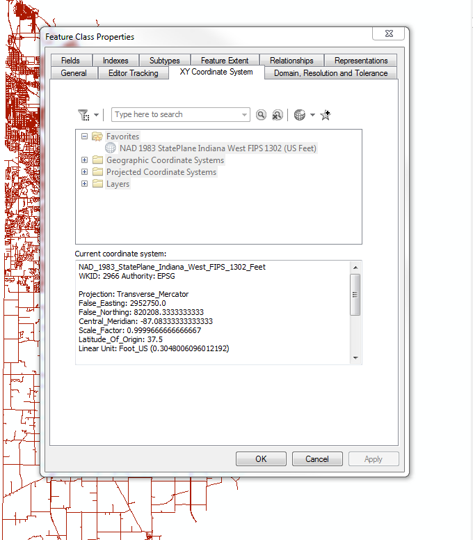
I see what you are saying. When I look at the URL for the service it does say 2245 is the spatial reference. However, the source layer I'm publishing from ArcMap is showing 2966. As seen in the screenshot below. Is it possible that there is some error happening in the publishing process to cause this? And if so, is there a way to fix that? I'm using ArcMap 10.6 to do this publishing.
- Mark as New
- Bookmark
- Subscribe
- Mute
- Subscribe to RSS Feed
- Permalink
- Report Inappropriate Content
Hi Matt -
I'm probably not the best resource for your issue now that we have determined that the problem occurs in the transfer from ArcMap -> ArcGIS Online (I am a Hub developer) . You may want to repost under a more appropriate GeoNet topic.
Indeed, it looks like your ArcMap data is in 2966. What is the spatial reference of the map that it is a layer in (in ArcMap)? Perhaps the map is in 2245, while the layer is in 2966; perhaps the publishing process use the map spatial reference rather than individual layers spatial reference.
- Mark as New
- Bookmark
- Subscribe
- Mute
- Subscribe to RSS Feed
- Permalink
- Report Inappropriate Content
The data frame properties of the map also show the correct projection system. Thanks for helping me narrow down where the problem appears to be occurring. I'll post in a more appropriate topic to hopefully get it solved
- Mark as New
- Bookmark
- Subscribe
- Mute
- Subscribe to RSS Feed
- Permalink
- Report Inappropriate Content
Hi Rich,
I was wondering if you would have some insight into something else I noticed. When I publish a layer on ArcGIS Pro and check the box that allows others to export to different formats, it makes a file geodatabase download option available on the ArcGIS Hub layer page. If I download the file geodatabase, it downloads the layer in the correct projection system. If I download the shapefile, it is still the incorrect projection system. Do you know of why that might be happening? Or is there a way for me to turn off the shapefile download option?
- Mark as New
- Bookmark
- Subscribe
- Mute
- Subscribe to RSS Feed
- Permalink
- Report Inappropriate Content
Can you post the link to the Hub page that has a geodatabase download? I don't see such an option here: https://data1-lakeingispro.opendata.arcgis.com/datasets/lakecounty-centerlines