Turn on suggestions
Auto-suggest helps you quickly narrow down your search results by suggesting possible matches as you type.
Cancel
- Home
- :
- All Communities
- :
- Products
- :
- ArcGIS Image Server
- :
- ArcGIS Image Server Questions
- :
- Re: How to work with Projections?!
Options
- Subscribe to RSS Feed
- Mark Topic as New
- Mark Topic as Read
- Float this Topic for Current User
- Bookmark
- Subscribe
- Mute
- Printer Friendly Page
How to work with Projections?!
Subscribe
3497
8
09-01-2011 04:22 AM
09-01-2011
04:22 AM
- Mark as New
- Bookmark
- Subscribe
- Mute
- Subscribe to RSS Feed
- Permalink
- Report Inappropriate Content
Dear all,
I´m trying to get all our data in cached services in Web-Mercator Auxillary Sphere to combine all our services with ArcGIS -Online Services. For vector data it is no problem.
However, we have a problem with our imagery, which are mainly 90GB of digital orthophotos projected in DHDN GERMANY ZONE 2 (Gauss -Krueger Zone 2, EPSG: 31466).
What is the best and easiest way to reproject this data? Is it possible by the server on the fly?
Reprojection of single files leads to black edges. Using them in a mosaic-dataset-file-geodatabase environment leads to correct Overviews and Pyramids, but original data is still not correctly displayed at a certain zoom-level. A projection shift is shown. I used a normal ArcGIS10- Image Service.
Any hints?
Kind regards,
Dirk
8 Replies
09-02-2011
06:24 AM
- Mark as New
- Bookmark
- Subscribe
- Mute
- Subscribe to RSS Feed
- Permalink
- Report Inappropriate Content
Image Server is capable of handling the scenario you are suggesting, without reprojecting the data. Here is a description of the process.
10-14-2011
03:04 AM
- Mark as New
- Bookmark
- Subscribe
- Mute
- Subscribe to RSS Feed
- Permalink
- Report Inappropriate Content
Is there a solution, without using Image Server Extension?
10-17-2011
03:34 AM
- Mark as New
- Bookmark
- Subscribe
- Mute
- Subscribe to RSS Feed
- Permalink
- Report Inappropriate Content
To perform the on-the-fly you will need the Image Server Extension. You can still go ahead and project the raster to the new coordinate system. With the mosaic dataset, make it the Web Mercator projection and then be sure that the rasters added are in the previous coordinate system. If you do not like the projection that the mosaic dataset chooses, then specify a different transformation. You can specify the transformation in the mosaic dataset properties under the default tab. Add the desired transformation there.
Otherwise you will have to reproject it and then either determine a polygon to clip out the NoData introduced during the projection or specify the background value and turn it off in the map document.
Otherwise you will have to reproject it and then either determine a polygon to clip out the NoData introduced during the projection or specify the background value and turn it off in the map document.
10-17-2011
07:16 AM
- Mark as New
- Bookmark
- Subscribe
- Mute
- Subscribe to RSS Feed
- Permalink
- Report Inappropriate Content
The issue you are seeing with the apparent shifts are most probably related to the definition of the datum transform. When using data with different transforms (eg Potsdam DHDN-WGS84) you need to define the transform to use as part of the Mosaic Dataset. If you look at the Mosaic Dataset|Properties/Defaults you will see a transforms section. You need to define all the transforms that you with to use with the Mosaic Dataset here. This is required as access to image can involve multiple transforms (eg client in UTM, Mosaic Dataset Defined in UTM Clark and source in DHDN). If not defined then defaults will be used, but these may not be suitable.
In the older Image Server (using ISDefs) this was also handled by using a Datums.dat file.
Concerning caching. If the data is just a set of tiles then one solution is to create a Mosaic Dataset and create the required overviews (all in the original projection). Then create the original files and overviews set of Raster Catalogs (1 for each pixel range). The Raster Catalogs can be added to a MXD document (set scales for different layers) and then cached. The simpler solution is to have the image extension. Then you add the Mosaic Dataset to a blank MXD and cache. (Note its is always recommended to keep the images in a separate cache as the vectors. This way you can use JPEG for the images and PNG for the vectors).
10-28-2011
06:53 AM
- Mark as New
- Bookmark
- Subscribe
- Mute
- Subscribe to RSS Feed
- Permalink
- Report Inappropriate Content
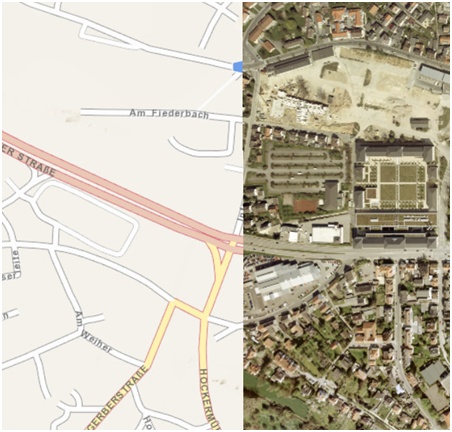
Thanks for your answers, but still a problem.
So from the scratch:
Then I start ArcMap, set the data frame to webmercator (aux. sphere), add an ESRI basemap service and afterwards the mosaic dataset. Thus, I got the same problem with the shift for the original data (see attached picture).
Did I do something wrong?
Kind regards,
Dirk
So from the scratch:
- I establish a mosaic dataset in a file GDB
- I assign to this mosaic dataset the coordinate system of the original data (DHDN Z3)
- I add the rasters from a folder
- I add in the properties of this mosaic dataset the transformations (DHDN to WGS84 and WGS84 to WGS4 Web Mercator)
Then I start ArcMap, set the data frame to webmercator (aux. sphere), add an ESRI basemap service and afterwards the mosaic dataset. Thus, I got the same problem with the shift for the original data (see attached picture).
Did I do something wrong?
Kind regards,
Dirk
10-28-2011
07:01 AM
- Mark as New
- Bookmark
- Subscribe
- Mute
- Subscribe to RSS Feed
- Permalink
- Report Inappropriate Content
Additionally:
the REST -API now shows a line:
Interesting!
the REST -API now shows a line:
Extent:

    XMin: 2494000.000000002
    YMin: 5627870.0
    XMax: 2500000.0000000005
    YMax: 5658000.000000001
    Spatial Reference: PROJCS["DHDN_3_degree_Gauss_zone_2",GEOGCS["GCS_DHDN",DATUM["D_Deutsches_Hauptdreiecksnetz",SPHEROID["Bessel_1841",6377397.155,299.1528128]],PRIMEM["Greenwich",0.0],UNIT["Degree",0.0174532925199433]],PROJECTION["Transverse_Mercator"],PARAMETER["false_easting",2500000.0],PARAMETER["false_northing",0.0],PARAMETER["central_meridian",6.0],PARAMETER["scale_factor",1.0],PARAMETER["latitude_of_origin",0.0],UNIT["Meter",1.0]]

Pixel Size X: 0.3124999999999272
Pixel Size Y: 0.31250000000000966
Interesting!
10-31-2011
09:23 AM
- Mark as New
- Bookmark
- Subscribe
- Mute
- Subscribe to RSS Feed
- Permalink
- Report Inappropriate Content
The issue may be related to the definition of the projection within the rasters. It may be that the datum in the raster is not defined such that it is recognized.
I got the same issue with some rasters that had DHDN defined internally.
This was resolve by defining the specific projection when the rasters are added. In the AddRasters use Advanced Options, Coordinate System for Input Data, then select National Grids, Germany and the appropriate projection.
I tried is out by defining the mosaic dataset in Web Mercator as well as defining it in the DHDN and it worked.
12-05-2011
07:13 AM
- Mark as New
- Bookmark
- Subscribe
- Mute
- Subscribe to RSS Feed
- Permalink
- Report Inappropriate Content
My solution for this topic is to use the Image Server Extension, which is capable of reprojection in this specific manner (DHDN to Web Mercator). Unfortunately, all other hints for this problem did not work. The original images used in a certain scale are still not at the right place. However, we found a very good solution and hope this problem will be regarded in future releases.