- Home
- :
- All Communities
- :
- Products
- :
- ArcGIS Living Atlas of the World
- :
- Living Atlas Questions
- :
- ESRI World Imagery Basemap display problem
- Subscribe to RSS Feed
- Mark Topic as New
- Mark Topic as Read
- Float this Topic for Current User
- Bookmark
- Subscribe
- Mute
- Printer Friendly Page
- Mark as New
- Bookmark
- Subscribe
- Mute
- Subscribe to RSS Feed
- Permalink
- Report Inappropriate Content
When I add the Esri World Imagery to my map, it is displaying on top of all the other layers, so that I can't see the other layers. This is only happening for one specific map project. I can't figure out how to get it (the basemap imagery) to display underneath the other layers.
Solved! Go to Solution.
Accepted Solutions
- Mark as New
- Bookmark
- Subscribe
- Mute
- Subscribe to RSS Feed
- Permalink
- Report Inappropriate Content
Hi Julie,
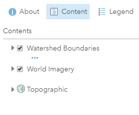
I'm assuming you are adding the World Imagery Basemap to your map in ArcGIS Online (ArcGIS.com) as opposed to ArcGIS Pro. I've provided 3 options of how to fix this. In my example, I added World Imagery to my project which blocks out my Watershed Boundaries and the Topographic Basemap -- Imagery hides these two layers beneath it, which is how I'm reading your question.

Option 1 - moving the layer
You can grab the layer by the 3 vertical gray dots on the left side and drag the layer below your operational layer(s), in my example below my Watershed Boundaries layer.

Which would produce a result like this -- and the watershed boundary layer is now visibile in the map.
--
Option 2 - moving the layer into the basemap
You can use the 3 horizontal blue dots (More Options) under the layer name and select Move to Basemap.

This moves imagery into the basemap layer (expand the layer by the small black triangle)

You can delete the Topographic layer if not needed through the More Options dots of the Topographic layer and select "Remove".
--
Option 3 - adding the layer as the basemap
If you really do want the Imagery layer to be the base layer (i.e. basemap) of your web map, when you are adding the Imagery layer to your project, click on the title of the layer (highlighted yellow below) and the details of the item will appear to the right. At the bottom of the details, there's a button for: Use as Basemap. Click to replace the existing basemap with World Imagery (in this example). It will keep your operational layers intact, above the base layer.

Notice, it also changes the name of the basemap layer, since World Imagery was set as our basemap, not just moved into the basemap layer like the other instruction above.

All the ways detailed here produce a similar result -- World Imagery below our operational layer (Watershed Boundaries) in the project. Hope this helps.
- Mark as New
- Bookmark
- Subscribe
- Mute
- Subscribe to RSS Feed
- Permalink
- Report Inappropriate Content
Hi Julie,
I'm assuming you are adding the World Imagery Basemap to your map in ArcGIS Online (ArcGIS.com) as opposed to ArcGIS Pro. I've provided 3 options of how to fix this. In my example, I added World Imagery to my project which blocks out my Watershed Boundaries and the Topographic Basemap -- Imagery hides these two layers beneath it, which is how I'm reading your question.
Option 1 - moving the layer
You can grab the layer by the 3 vertical gray dots on the left side and drag the layer below your operational layer(s), in my example below my Watershed Boundaries layer.
Which would produce a result like this -- and the watershed boundary layer is now visibile in the map.
--
Option 2 - moving the layer into the basemap
You can use the 3 horizontal blue dots (More Options) under the layer name and select Move to Basemap.
This moves imagery into the basemap layer (expand the layer by the small black triangle)
You can delete the Topographic layer if not needed through the More Options dots of the Topographic layer and select "Remove".
--
Option 3 - adding the layer as the basemap
If you really do want the Imagery layer to be the base layer (i.e. basemap) of your web map, when you are adding the Imagery layer to your project, click on the title of the layer (highlighted yellow below) and the details of the item will appear to the right. At the bottom of the details, there's a button for: Use as Basemap. Click to replace the existing basemap with World Imagery (in this example). It will keep your operational layers intact, above the base layer.
Notice, it also changes the name of the basemap layer, since World Imagery was set as our basemap, not just moved into the basemap layer like the other instruction above.
All the ways detailed here produce a similar result -- World Imagery below our operational layer (Watershed Boundaries) in the project. Hope this helps.