- Home
- :
- All Communities
- :
- Products
- :
- ArcGIS Living Atlas of the World
- :
- Living Atlas Questions
- :
- Street basemap without building outline?
- Subscribe to RSS Feed
- Mark Topic as New
- Mark Topic as Read
- Float this Topic for Current User
- Bookmark
- Subscribe
- Mute
- Printer Friendly Page
Street basemap without building outline?
- Mark as New
- Bookmark
- Subscribe
- Mute
- Subscribe to RSS Feed
- Permalink
- Report Inappropriate Content
I'm wanting to show streets and street names, but most of the basemaps i have tried all show building outline which is not wanted for this purpose.
- Mark as New
- Bookmark
- Subscribe
- Mute
- Subscribe to RSS Feed
- Permalink
- Report Inappropriate Content
Yes, just about all our basemaps do contain building footprints at the larger map scales. But there is an option to customize one of our vector basemap styles using the Vector Tile Style Editor app to turn these features off. When you're logged in to ArcGIS Online you can either access the app directly, or you can access it through the Tile Layer in the Contents of your Map. I'll detail accessing the Editor through the Content of the Map.
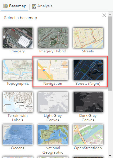
Make sure your basemap gallery is showing Vector Maps. Navigation and Streets (Night) among others further down the list are only available as vector basemaps. You (your org admin) can set the default gallery to be vector maps.
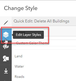
I'm selecting the Navigation style street map for this example. In the map content, expand to see the layer for World Navigation Map and the little icon of the circle, square, and triangle. This opens the Vector Tile Style Editor. Rename your map style, add some tags and save it to your ArcGIS Content. This will be your custom map style. (I named my map: "Delete All Buildings")

You'll want to pick Edit Layer Styles icon from the far left menu tab. This allows you to select a feature layer in the map and make adjustments.
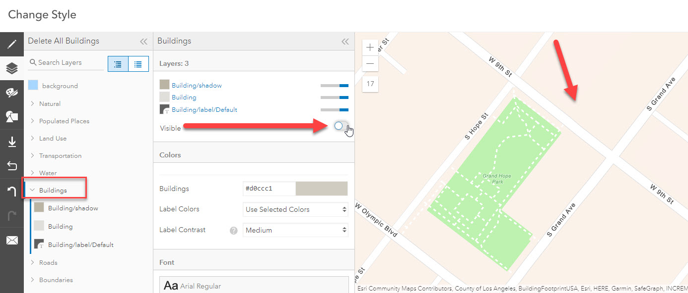
In the list of layer names, find the Buildings layer, select it, and make the change you want. You can change the colors of the building footprints, building shadows, building outline, etc. The "Visible" toggle switch can be flipped to turn all Building features off with one click.

The map will redraw on the fly. Buildings OFF ("Visible" switched off).
Other features can be controlled the same way. Change colors, line widths, font faces, font sizes, etc.
Click "Save Style and Close". This takes you back to the main map page in ArcGIS Online. You can use your customized vector basemap tile layer in web maps and apps. The web map you make can also be added to a group that is used in a custom basemap gallery.
This workflow shown was in ArcGIS Online, but can be replicated in ArcGIS Enterprise starting at version 10.8.x.
- Mark as New
- Bookmark
- Subscribe
- Mute
- Subscribe to RSS Feed
- Permalink
- Report Inappropriate Content
Thanks Robert. I was able to go through the steps and create that basemap I wanted. I am however looking to use this basemap in ArcGIS desktop. Is there any way to publish or make it available to use for desktop?
- Mark as New
- Bookmark
- Subscribe
- Mute
- Subscribe to RSS Feed
- Permalink
- Report Inappropriate Content
Esri Vector Basemaps are designed for use in the following clients:
ArcGIS Pro, ArcGIS Online (JavaScript API), Runtime apps (Navigator, Explorer, Collector, etc.)
ArcGIS Pro can also create the Vector Tiles.
ArcGIS Desktop (ArcMap) is one application the vector basemaps cannot be viewed through. You would need to use a raster basemap layer in this client. Because the rasters are static JPG (or PNG), components within the map (e.g. buildings) cannot be removed like the vector maps. Please note the Esri Raster Basemaps are scheduled for migration into Mature support.
Side note if working only in ArcGIS Desktop (ArcMap)
There are three raster basemap layers from Esri that may be of interest to you. They are World Boundaries and Places, World Transportation, and World Hybrid Overlay. These are raster reference layers designed to be used over imagery. They do not contain buildings (among other features not included). They have streets, city names, and other labels. Because they are reference overlay layers, they also don't contain water polygons or other features that would make them a complete street map.
Another map to consider is the USGS National Map. It does not contain buildings but it does provide a more complete map. There are two notes: 1) the largest scale of this map is 1:9K (or LOD 16) and 2) Esri does not maintain this raster tile service.