- Home
- :
- All Communities
- :
- Products
- :
- Mapping and Charting Solutions
- :
- Mapping and Charting Questions
- :
- Re: Creating custome line symbology
- Subscribe to RSS Feed
- Mark Topic as New
- Mark Topic as Read
- Float this Topic for Current User
- Bookmark
- Subscribe
- Mute
- Printer Friendly Page
Creating custome line symbology
- Mark as New
- Bookmark
- Subscribe
- Mute
- Subscribe to RSS Feed
- Permalink
- Report Inappropriate Content
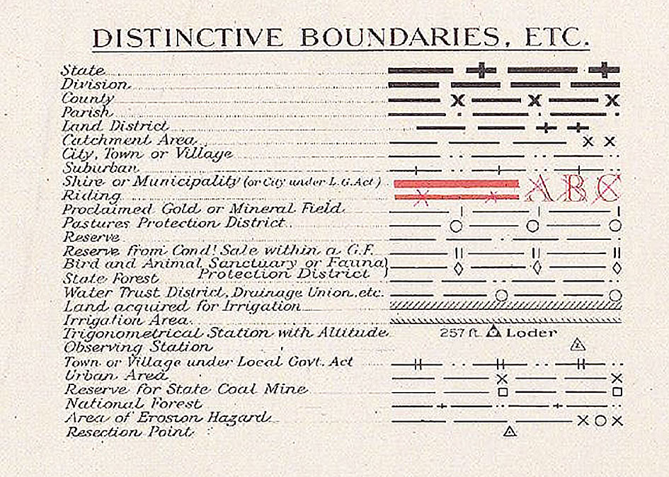
In the 19th C the Lands Department in New South Wales had a set of specific line styles that they used to symbolise polygons relating to different land characteristics (ie County Boundary, Parish Boundary, Town Boundary...etc) on their reference maps. I am interested in trying to reproduce this symbology and have tried editing styles but with limited success. is there more than one way to do this in ArcGIS? Can line symbols be created in another program - such as Coral Draw and imported into ArcGIS.
Cheers
Iain
- Mark as New
- Bookmark
- Subscribe
- Mute
- Subscribe to RSS Feed
- Permalink
- Report Inappropriate Content
Do you have an example of the line symbology that you are trying to create?
Have you tried representations?
- Mark as New
- Bookmark
- Subscribe
- Mute
- Subscribe to RSS Feed
- Permalink
- Report Inappropriate Content
- Mark as New
- Bookmark
- Subscribe
- Mute
- Subscribe to RSS Feed
- Permalink
- Report Inappropriate Content
I think many of these line symbol are already present or can be recreated based on an existing line symbol (just switch on the other Style references that are normally switched off). You can tailor them more precise using representations.
Is there a specific line symbol that you have problems with?