- Home
- :
- All Communities
- :
- Products
- :
- Mapping and Charting Solutions
- :
- Mapping and Charting Questions
- :
- polygon x y coordinate update when move in edit
- Subscribe to RSS Feed
- Mark Topic as New
- Mark Topic as Read
- Float this Topic for Current User
- Bookmark
- Subscribe
- Mute
- Printer Friendly Page
polygon x y coordinate update when move in edit
- Mark as New
- Bookmark
- Subscribe
- Mute
- Subscribe to RSS Feed
- Permalink
- Report Inappropriate Content
I am retrodeforming a geologic map and need to manually move several hundred simple polygons (basically bowties) to new locations based on a new geologic reconstruction. When I move the polygons in edit mode, the xy coordinates in the attribute table are not updated. I need to access this updated this information to do some additional calculations. Any help in recalculating the xy coordinates would be helpful.
- Mark as New
- Bookmark
- Subscribe
- Mute
- Subscribe to RSS Feed
- Permalink
- Report Inappropriate Content
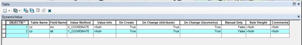
You need to use Attribute Assistant to do automatic updates during editing. It has X and Y Coordinate methods for maintaining centroid coordinates or the end points of lines (which for a polygon are both the location of boundary closure). You can download Attribute Assistant here by pressing the Download button. You then need to modify the dynamicValues table to include lines for the X and Y coordinate methods that target your polygon feature class. Here is an example of the rows you would need in the dynamicValue table if the Feature Class is named MyPolygons and the fields to maintain are called X_COORD and Y_COORD:
| Table Name | Field Name | Value Method | Value Info |
| MyPolygons | X_COORD | X_COORDINATE | Null |
MyPolygons | Y_COORD | Y_COORDINATE | Null |
These rows should check as True the options to update when features are created and geometry is updated. Add that table to the map where you are going to edit your layer. Make sure the Attribute Assistant is active in the Attribute Assistant toolbar.
For features you moved previously use the Geometry calculator on your fields to bring them up to date (right click the field column name, choose Geometry Calculator and choose Centroid X and Y options as appropriate) and then maintain them going forward with Attribute Assistant.
- Mark as New
- Bookmark
- Subscribe
- Mute
- Subscribe to RSS Feed
- Permalink
- Report Inappropriate Content
Thank you Richard for the response. I tried the steps you suggested and got an incorrect set of new coordinates. for example, here is my DynamicValues table:
here is a shot of the attribute table of six polygons before I moved them:
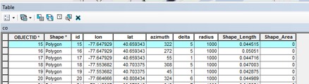
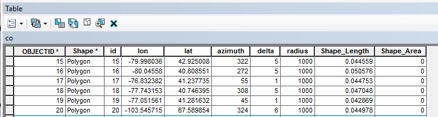
For a test, I moved each one to the same location: -77.75000, 40.75000, and this is the updated table:
I got a similar result when I did a different test using just the Geometry Calculator on moved polygons.
I admit, I am by no means an expert on ArcGIS, and only learn as I go to get a task done. Any suggestions to remedy this would be helpful.
- Mark as New
- Bookmark
- Subscribe
- Mute
- Subscribe to RSS Feed
- Permalink
- Report Inappropriate Content
I have to assume the new coordinates calculated are correct for the projection your data is in if both the Geometry Calculator and Attribute Assistant produce similar results. How were your original coordinates assigned?
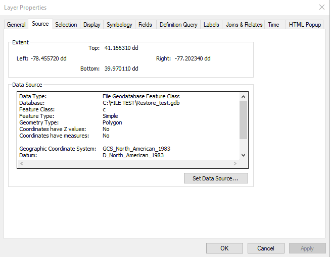
What is your layer's projection and what is your data frame projection? You should not edit spatial data when they are different. Look at the layer properties on the source tab and print a screenshot of the coordinate system it shows. Then right click the map view and choose properties and screenshot the coordinate system tab. If they are different you would need to either use the Project tool to get your layer to match the desktop, or change the desktop projection to match the layer before doing any spatial editing.
As far as moving the polygons to the same location, how are you doing that? The centroid of each polygon must be set to the position you assigned to get the output to match.
- Mark as New
- Bookmark
- Subscribe
- Mute
- Subscribe to RSS Feed
- Permalink
- Report Inappropriate Content
Richard,
The original coordinates were assigned by creating a shapefile in R. they are the centroid of polygons. The polygons are bow-tie shaped and reflect the orientation of fractures in rock. Here is a screenshot of the bowties at 1:100,000 over a geologic map. There are several bowties stacked over one another at each location.
Here are the projections (I created a new file that is simplified to include only the layer with the bowties):
[cid:image006.png@01D291A1.2C5F2200]
I am trying ot move the bowties while in edit mode. The attribute table is updated when I move the bowties, but some will be updated with the correct new coordinates of the centroid, but most of them will end up with really off values (e.g. longitudes of 6589.98).
The reason that I would like to move the bowties in edit mode is that the new restored geologic map that I created and imported into ArcMap is a highly distorted map stretched in photoshop. The new locations of the geologic sites are not mathamatically related to the original sites. I would like to effcitively drag the old bowties to the new locations. Then, ideally, export the new attribute table into excel to change the orientations of the bowtie values, reprocess in R to create a new bowtie shapefile in the new locations with the revised orientations.
I hope this helps. Except for tediously writing into excel the new locations for each of several hundred sites, I don’e know another way around this.
Thanks for your time.
Mark
Mark A. Evans
Professor of Geology and Chair
Department of Geological Sciences
Central Connecticut State University
1615 Stanley Street
New Britain, CT 06050
Office: 860.832.2936
Fax: 860.832.2946
Cell: 860.707.6602
Website: http://www.ccsu.edu/geolsci/
- Mark as New
- Bookmark
- Subscribe
- Mute
- Subscribe to RSS Feed
- Permalink
- Report Inappropriate Content
For the source tab picture I need you to scroll to the bottom of the list in the text box to see the coordinate settings. I oly see two lines of part of the spatial settings for your layer and not all of them.
I have faith in the Geometry Calculator. I suspect corruption in your layer or your map. Complex self-intersecting polygons like bow-ties have to observe all of the ArcMap geometry rules for ring order and boundary orientation to avoid strange results being produced. I don't know that R respects all of those rules. I would run the Repair Geometry tool on the layer and export it to a new layer. I would also add the new layer to a blank map and do the Geometry Calculator on the whole thing to see what output it gives.
I also want to be sure that each feature is just a single bow tie and none of these features are disjointed multi-part features with large gaps between parts. Select one of the features with an odd coordinate in edit mode and zoom to the feature extent. Verify you see a single bow tie and that the centroid crosshair is inside the polygon at the center of the bow tie.