- Home
- :
- All Communities
- :
- Products
- :
- ArcGIS Network Analyst
- :
- ArcGIS Network Analyst Questions
- :
- Re: Incomplete Service Area
- Subscribe to RSS Feed
- Mark Topic as New
- Mark Topic as Read
- Float this Topic for Current User
- Bookmark
- Subscribe
- Mute
- Printer Friendly Page
Incomplete Service Area
- Mark as New
- Bookmark
- Subscribe
- Mute
- Subscribe to RSS Feed
- Permalink
- Report Inappropriate Content
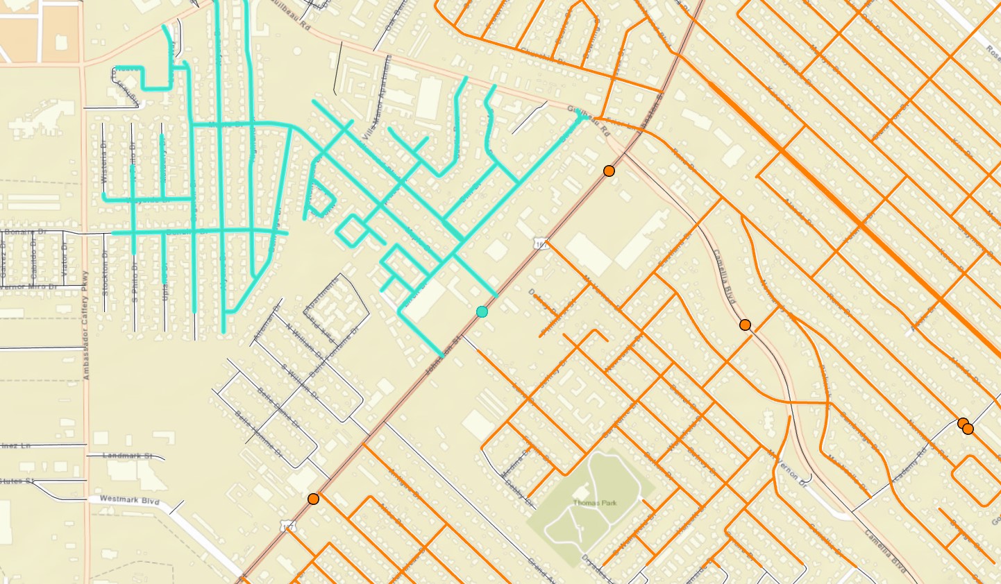
I am using our cities centerline feature layer and merged our bike route feature layer. I have run topology and fixed the errors that it found. What we are trying to do is find which portions of the new bike route give the most access to local roads. The facility points in the analysis are the acutely center point of each new bike route segment. We run the service analysis from that facility point, the cutoff is 1mi, the buffer is 1000ft, I have set restrictions to prohibit access to major collectors, major arterial roads and interstates. There are no field that indicate street direction in our database. But when i run the analysis it appears to only show the service area on one side of the street, not both even if the adjacent street is directly across from the facility point. i have attached a screenshot. blue indicates the streets included in the analysis for that point, but you can clearly see streets directly across that are not included. If I use the complete set of centerlines (no restrictions) it will show service area on either side of road.
do you think there is something wrong with the dataset, the restrictions, etc....

- Mark as New
- Bookmark
- Subscribe
- Mute
- Subscribe to RSS Feed
- Permalink
- Report Inappropriate Content
I'm having a little bit of trouble understanding exactly what your screenshot is showing, but here's a guess. You said you set up some restrictions to prevent bike travel on major collectors, major arterial roads and interstates. The locations where your facilities are located look like they are on larger roads. Are those collectors? It kind of looks like the facility is getting snapped to the closest non-restricted road segment (one of those side roads), and, since bikes aren't allowed on the main road, it can't cross the street and get into the neighborhood on the other side.
One thing that might help you visualize what's going on is configuring the network dataset layer symbology to show the restriction status. You can configure the edge symbology to show the edges that are restricted according to a specific travel mode. Here is some documentation about network dataset symbology: https://pro.arcgis.com/en/pro-app/latest/help/analysis/networks/network-dataset-layer-symbology.htm
- Mark as New
- Bookmark
- Subscribe
- Mute
- Subscribe to RSS Feed
- Permalink
- Report Inappropriate Content
Yes the proposed new bike routes are located on some of the major roads. the facility point is snapped to the center of the bike route/major road. we are only interested in the "local" designated roads that cyclist will be able to access if the new bike routes are built. the restriction of major roads was added to analysis because it would be too dangerous to access if a bike route was not there (most major roads will not have a bike route). the "blue" lines indicate only local roads that are accessible from that point in a one mile cutoff radius as indicated by the service area analysis. the "orange" roads are roads that fall into a different bike route faculty point as indicated by the service area analysis. "black" are roads not within a 1mi cutoff. so if I set restriction, it will only pick the closes road on one side of the street even though there is no street direction indicated or bike route direction indicated. Just to make note all roads and bike routes in our project are two way streets, so direction should not be an issue. I have the analysis "type" set to driving, not walking/trucking/other. Should it be set to walking instead of driving? is there a way to indicate that travel is allowed in all directions?
I will look into layer symbology and see if that helps me understand why it would not pick up a road that is 20 feet away but well within the 1mile analysis area per facility point. thanks for your fast response..
- Mark as New
- Bookmark
- Subscribe
- Mute
- Subscribe to RSS Feed
- Permalink
- Report Inappropriate Content
The travel mode type doesn't really do a whole lot, but if you set it to Walking, it will use a smaller pixel size for your Service Areas and make the polygons a bit more detailed. But it doesn't do anything to affect the actual analysis result.
If your road is "major" but also has a bike lane, you should probably just make it not restricted. Otherwise, bikes won't be able to ride there, which isn't your intention.
Note that crossing major roads can still be a challenge/problem on a bike, so it may not be that inaccurate to show that the area across the street is inaccessible unless you have good infrastructure for crossings and left turns.
- Mark as New
- Bookmark
- Subscribe
- Mute
- Subscribe to RSS Feed
- Permalink
- Report Inappropriate Content
Thanks for clarification on the travel mode. I will keep at it and figure something out. But lets suppose, as an example, that each of my points were a pizza place and we only wanted delivery drivers to use local roads. I would get the same results as I do now, correct? The team that needs the analysis is going to pick which segments of the proposed bike route to complete first with current funding. those sections which offer the most access will be built first. The other sections could be a yr or more away. So they did not want to use the proposed bike routes as a viable mode of transporation because it may be years before an adjacent section is completed. Hence why bike route/major road is not included in a possible route. Just not sure how to make it recognize the opposite side of the street (bike lanes will be on both sides of the street, so need to see access on all). thanks for your assistance.
I did apply the symbology changes as you suggested. it showed the restrictions as "red" and populated node points at each intersection, no errors were indicated in the symbology.
- Mark as New
- Bookmark
- Subscribe
- Mute
- Subscribe to RSS Feed
- Permalink
- Report Inappropriate Content
You could change your restriction's usage type to "Avoid High" instead of "Prohibited". This will allow the biker to use the large roads if no other path is available. Documentation: https://pro.arcgis.com/en/pro-app/latest/help/analysis/networks/restriction-attributes.htm#GUID-E02C...