- Home
- :
- All Communities
- :
- Products
- :
- ArcGIS Online
- :
- ArcGIS Online Questions
- :
- ArgGis online - WebApp/WebMap
- Subscribe to RSS Feed
- Mark Topic as New
- Mark Topic as Read
- Float this Topic for Current User
- Bookmark
- Subscribe
- Mute
- Printer Friendly Page
ArgGis online - WebApp/WebMap
- Mark as New
- Bookmark
- Subscribe
- Mute
- Subscribe to RSS Feed
- Permalink
- Report Inappropriate Content
Hi! Me and my group at the University of Gent are developing a project; we're making an WebApp Online on ArcGis, we added quite some layers, but now we want them to appear just when selected! How can we do this? Also, when doing the apresentation, we'd like the Webapp to appear with less zoom, I mean, show both the USA & Europe coast + UK + Iceland for example, instead of showing just the Belgian coast. I installed the ArcGis Desktop, but still can't figure it out...
- Mark as New
- Bookmark
- Subscribe
- Mute
- Subscribe to RSS Feed
- Permalink
- Report Inappropriate Content
Hi Catarina,
First, you'll need to create an ArcGIS Online account. You should check with your university if they might already have an ArcGIS Online organization you can join, or you can create a free 60-day trial account:
http://www.arcgis.com/features/free-trial.html?origin=arcgis
To start creating web apps, I suggest you start here:
- Make your first app—ArcGIS Online Help | ArcGIS
- ArcWatch | Create Web Apps Rapidly Using Web AppBuilder for ArcGIS
Hope this helps,
- Mark as New
- Bookmark
- Subscribe
- Mute
- Subscribe to RSS Feed
- Permalink
- Report Inappropriate Content
As you can read in my question we already did that...
- Mark as New
- Bookmark
- Subscribe
- Mute
- Subscribe to RSS Feed
- Permalink
- Report Inappropriate Content
Are you keeping the map in Arcgis Online or will you have a Javascript application?
On AGOL when you save your map it will open next time at that zoom level.
"but now we want them to appear just when selected! How can we do this?"
Are you asking if you have it turned on (checked)? or when you click the map the layer appears?
- Mark as New
- Bookmark
- Subscribe
- Mute
- Subscribe to RSS Feed
- Permalink
- Report Inappropriate Content
Hm good question! Well, the assignment is to "develop a set of sensors to integrate in non-manned vessel which sends data via satellite at set intervals. Data should be visualized on a web-based GIS. Sensors have to make use of open source Arduino technology."
So.. we need an online map that can be implemented into a web-application publicly accessible, and so anyone can get updates on the location of the vessel at any given time.
Yes the aim is to click so the layer appears; we have quite many, so it's confusing/useless to have them all at the same time..
- Mark as New
- Bookmark
- Subscribe
- Mute
- Subscribe to RSS Feed
- Permalink
- Report Inappropriate Content
Hi Catarina,
> As you can read in my question we already did that...
My impression from your original post was that you had only initially explored ArcGIS Online, but had not created an app yet. What app option did you use: the configurable application templates or Web AppBuilder?
> we'd like the Webapp to appear with less zoom, I mean, show both the USA & Europe coast + UK + Iceland for example, instead of showing just the Belgian coast.
The map display extent is meant to be dynamic, but you can define spatial bookmarks in the ArcGIS Online map viewer. In Web AppBuilder, you can also limit the scale that an be zoomed to - this setting is found on the Map tab.
> Yes the aim is to click so the layer appears; we have quite many, so it's confusing/useless to have them all at the same time.
As Rickey said in his post, you can control when the layers appear in the map display by clicking them on/off in the table of contents of the web map in the ArcGIS Online map viewer. In Web AppBuilder, you can further control when layers appear with the LayerList widget.
Hope this helps,
- Mark as New
- Bookmark
- Subscribe
- Mute
- Subscribe to RSS Feed
- Permalink
- Report Inappropriate Content
Do you mind if I give you the credentials to log in in ArcGis so you can check? Sorry it's because we are really running out of time and it's confusing for me, especially under pressure and with so many classes 
- Mark as New
- Bookmark
- Subscribe
- Mute
- Subscribe to RSS Feed
- Permalink
- Report Inappropriate Content
"you can further control when layers appear with the LayerList widget"
How? And they must be all checked?
They are at least 18 layers!
- Mark as New
- Bookmark
- Subscribe
- Mute
- Subscribe to RSS Feed
- Permalink
- Report Inappropriate Content
As you can see in my two images, the layers that are checked on show in the webapp.
AGOL map

Webapp
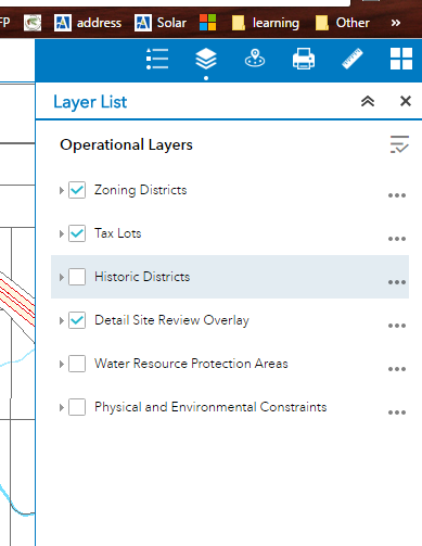
Webapp Config

- Mark as New
- Bookmark
- Subscribe
- Mute
- Subscribe to RSS Feed
- Permalink
- Report Inappropriate Content
Ok think I got it.. what about sharing the APP with everyone? It ask to login in ArcGis in order to see it.