- Home
- :
- All Communities
- :
- Products
- :
- ArcGIS Online
- :
- ArcGIS Online Questions
- :
- Best ZIP, Tract, and Block Group layers for AGOL
- Subscribe to RSS Feed
- Mark Topic as New
- Mark Topic as Read
- Float this Topic for Current User
- Bookmark
- Subscribe
- Mute
- Printer Friendly Page
Best ZIP, Tract, and Block Group layers for AGOL
- Mark as New
- Bookmark
- Subscribe
- Mute
- Subscribe to RSS Feed
- Permalink
- Report Inappropriate Content
What are the best ZIP, Census Tract, and Block Group layers to use in AGOL?
I used to use for ZIPs the "USA ZIP Codes (2015)" layer. Now I see that Living Atlas has what looks like Esri maintained layers for ZIP, Tract, and Block Group with no years on them. The blurbs say they are special versions that work good on AGOL. Is this true? Should I use these?
In the past, I did tract uploades form Census .shp files, a pain. And didn't bother with blocks because it seemed like too much time to draw.
Will somebody at Esri say that "yes, we made these new layers, use them, we will maintain them, and not screw them up ever." for the following layers:
https://honorhealth.maps.arcgis.com/home/item.html?id=2a0f46361c05465eb89d4aa417d6ad08
https://honorhealth.maps.arcgis.com/home/item.html?id=fe6374385966414687ec0396146fdba6
https://esri.maps.arcgis.com/home/item.html?id=0a2fde8aa7404187917488bafcbc77e6
I'd love to know the exact use case of these layers and their release history, if there is such a thing?
- Mark as New
- Bookmark
- Subscribe
- Mute
- Subscribe to RSS Feed
- Permalink
- Report Inappropriate Content
The ESRI provided Census data is reliable and up-to-date. Look for the authoritative tag on living atlas layers. that indicates that the data is published by ESRI or an approved organization.
From the authoritative content blog post
One source that many of us turn to first is the ArcGIS Living Atlas of the World, which is built-in to ArcGIS Online and now accessible to all users creating content through the Living Atlas tab on the Content page. The Living Atlas includes content that is curated by Esri, which may be published by Esri, our business partners, or ArcGIS users. The Living Atlas now includes about seven thousand items of various types that have been contributed.
- Mark as New
- Bookmark
- Subscribe
- Mute
- Subscribe to RSS Feed
- Permalink
- Report Inappropriate Content
Yes, I'm aware of that. But in the past, there were NO tract and block layers on AGOL or Living Atlas. There are 3 different versions of ZIP layers that are all by ESRI or esri_dm. One says it is only for d/l for Pro and ArcMap users, the other 2 appear to be the same, but one has a 2018 data attached, the other no date. I'm looking for somebody that can tell me what is the best layer to use, as in it will not be rolled back or changed without warning.
Thanks for the reply! Hopefully somebody will know my answer.
- Mark as New
- Bookmark
- Subscribe
- Mute
- Subscribe to RSS Feed
- Permalink
- Report Inappropriate Content
Hi Jay,
For enriching the boundaries with attribute data in ArcGIS Online, I would definitely recommend using one of the layers optimized for Data Enrichment analysis performance. This is also the content marked as authoritative/Living Atlas. From the Content Team's previous practices, I don't think they would roll back a layer but would rather deprecate it as they've done for previous years' zip codes. This happens on a yearly basis and we would expect the authoritative layer to change to Zip Code Boundaries 2019, from 2018.
I'm also cross-posting this to Business Analyst and ArcGIS Living Atlas of the World to confirm my understanding here.
Is the item you are seeing for d/l only the Layer Package? You definitely wouldn't want to download/republish this to ArcGIS Online when there are readily available Feature Layers.
What is the workflow you are using the Zip Codes/Tracts/Blocks layers in?
Hope that helps,
-Peter
- Mark as New
- Bookmark
- Subscribe
- Mute
- Subscribe to RSS Feed
- Permalink
- Report Inappropriate Content
Routine display and enrichment of these various types of boundaries.
I just want to make sure I know how to get the latest, canonical version of these boundaries. E.g. how do I know if I need to check for a year or not? Also, the ZCTA Census "ZIP" boundaries are WAY different than the TomTom/HERE/whatever boundaries. We standarized on the Census ZCTA/ZIP ones. (Oddly, only can use TomTom/HERE ones in Business Analyst Online.)
I don't want the layer boundaries to be subject to change afterwards, and also want to make sure we do have the latest. There are at least 2 versions from ESRI or esri_dm that appear to be the same, some have years, some don't.
It's weird.
All are in the "Living Atlas".
I'd like it if they just tacked the year on everything, for starters. But, glad to see them curating this content for us, way nicer.
Anybody know where I can get the definitive answer?
- Mark as New
- Bookmark
- Subscribe
- Mute
- Subscribe to RSS Feed
- Permalink
- Report Inappropriate Content
Hi Jay,
I reached out to the content team internally and have a definitive answer for you:
United States ZIP Code Boundaries 2018 is the best layer to use if the application can change source URL annually. An updated version of this layer, along with the other 5 layers (State, Tract, etc.) is published annually with the year in the title, and previous annual layers are retained but deprecated. Unfortunately there was a delay in publishing the updated ZIPs for 2019; the 2019 USA Zip Code layer will be published in the next couple weeks.
USA Zip Code Areas is published to a fixed URL and updated annually. Unlike the 2018 ZIP Code layer described in the first bullet which is published new and additional each year, this layer retains a fixed URL and the underlying data is updated. Applications that require a fixed URL should use this one.
"The ZCTA Census "ZIP" boundaries are WAY different than the TomTom/HERE/whatever boundaries"
> This is true - the only USA ZIP code boundaries Esri has license to redistribute as an ArcGIS Online Feature Layer are from TomTom.
Hope this helps, and have a good weekend ahead ~
-Peter
- Mark as New
- Bookmark
- Subscribe
- Mute
- Subscribe to RSS Feed
- Permalink
- Report Inappropriate Content
Outstanding! Fantastic answer, thanks for hanging in there with me. It was what I was hoping the answer was.
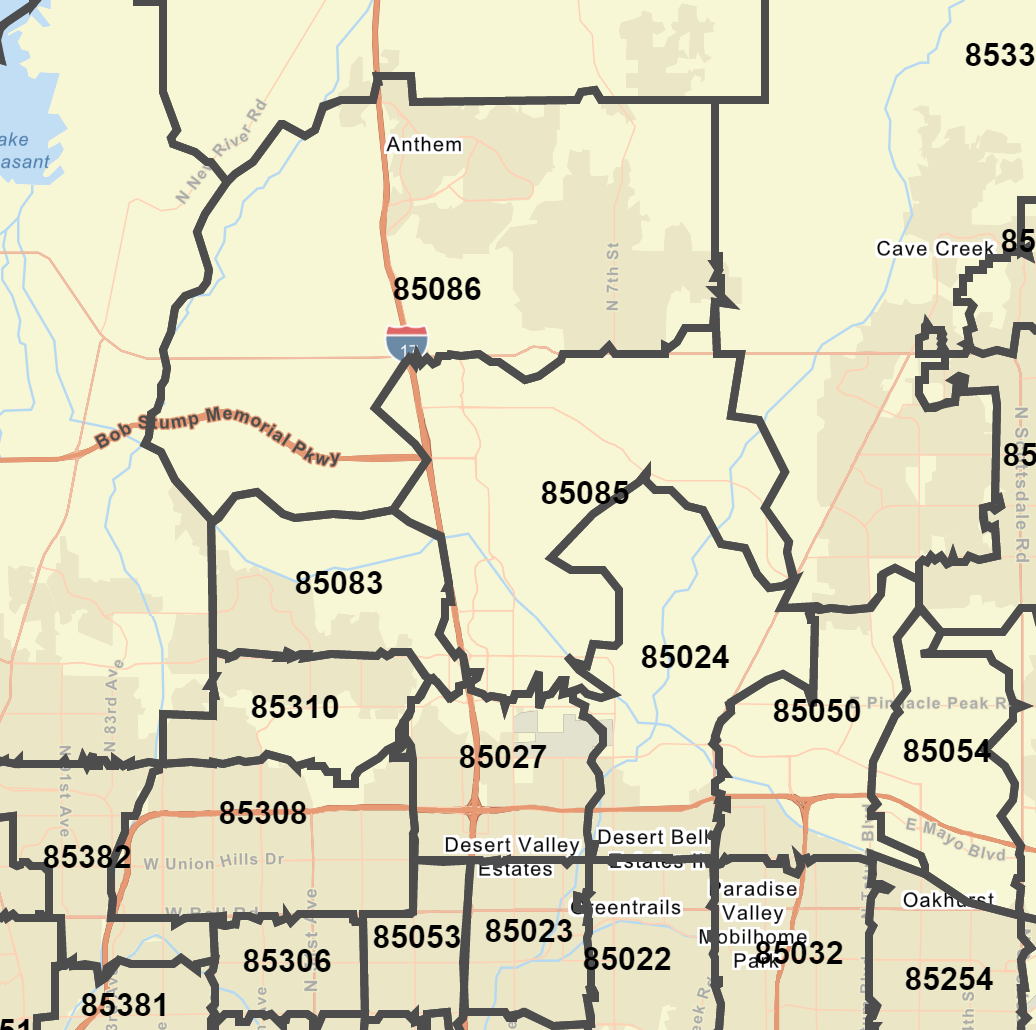
One note: the ZIP layers in Living Atlas/AGOL are what I call the "ZIP/ZCTA census outlines". I can tell from the shape of some of our key ZIPs, 85085 and 85086.
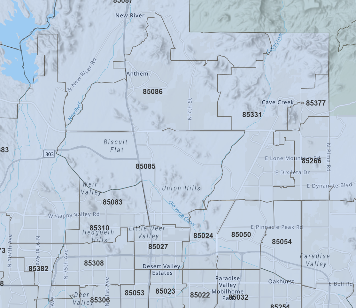
and
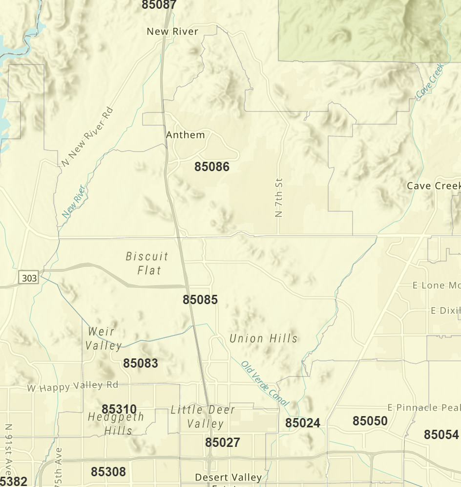
Here's what a call the TomTom/HERE ZIPs in BAO, totally different. I understand they might be closer to actual USPS behavior for delivery, and this is a value-add for many customers, but for us this difference means that we can't really use BAO maps for any ZIP-based work.
Thanks very much, have a great weekend.
- Mark as New
- Bookmark
- Subscribe
- Mute
- Subscribe to RSS Feed
- Permalink
- Report Inappropriate Content
Hi Jay, glad to hear that was helpful - and thanks for the clarification. Have a great weekend as well!