Turn on suggestions
Auto-suggest helps you quickly narrow down your search results by suggesting possible matches as you type.
Cancel
- Home
- :
- All Communities
- :
- Products
- :
- ArcGIS Online
- :
- ArcGIS Online Questions
- :
- Re: Unable to Create New Features in an Editable L...
Options
- Subscribe to RSS Feed
- Mark Topic as New
- Mark Topic as Read
- Float this Topic for Current User
- Bookmark
- Subscribe
- Mute
- Printer Friendly Page
Unable to Create New Features in an Editable Layer Using Web Mapping Application
Subscribe
3471
10
05-30-2013 07:09 AM
05-30-2013
07:09 AM
- Mark as New
- Bookmark
- Subscribe
- Mute
- Subscribe to RSS Feed
- Permalink
- Report Inappropriate Content
Greetings!
We wanted to develop a very basic web mapping application that would allow end-users the ability to add, update, and delete features for an editable layer (in this case a road network).
I have completed the following:
1.) Developed/shared a web map
2.) Published and Downloaded a web mapping application using the configurable Basic Viewer application template (with feature editing capability) available from ArcGIS online.
3.) Installed on our web server, and performed some minor customization.
Almost everything looks great, and performs as it should, with one exception: We are unable to add new features to the editable layer. We can select existing features and modify/delete them, but we can't add new. I am not using ArcGIS Server.
I might also add that if I publish the web mapping application directly to ArcGIS online, I can perform edits just fine.
What am I missing? My head hurts from beating it against this brick wall...
Should I have posted this in the JavaScript API Forum?
Thank you in advance!
Jason
10 Replies
05-30-2013
12:31 PM
- Mark as New
- Bookmark
- Subscribe
- Mute
- Subscribe to RSS Feed
- Permalink
- Report Inappropriate Content
What is the source of the layer you want to edit? If you uploaded a shapefile or CSV into the map, or added a Map Notes layer, these layers don't support multiple user editing. Only the owner of the map will be able to edit the data. Others can edit the data but would not be able to save changes back to the original map, instead saving as a new map.
The only types of layers that support multi user editing are those based on feature services, either running on ArcGIS Server or hosted as part of an ArcGIS Online subscription.
Thanks,
Mike
The only types of layers that support multi user editing are those based on feature services, either running on ArcGIS Server or hosted as part of an ArcGIS Online subscription.
Thanks,
Mike
05-30-2013
01:16 PM
- Mark as New
- Bookmark
- Subscribe
- Mute
- Subscribe to RSS Feed
- Permalink
- Report Inappropriate Content
Mike,
The layer was uploaded from a zipped shapefile, and then published as a feature service hosted as part of our ArcGIS Online for Organizations subscription.
Jason
The layer was uploaded from a zipped shapefile, and then published as a feature service hosted as part of our ArcGIS Online for Organizations subscription.
Jason
05-30-2013
01:49 PM
- Mark as New
- Bookmark
- Subscribe
- Mute
- Subscribe to RSS Feed
- Permalink
- Report Inappropriate Content
How have you configured editing on the feature service? Go to the item page of the feature service and click the Edit button. Scroll down the page to see these options.
Enable editing and allow editors to:
- Add, update, and delete features
- Update feature attributes only
- Add features only
Thanks,
Mike
Enable editing and allow editors to:
- Add, update, and delete features
- Update feature attributes only
- Add features only
Thanks,
Mike
05-30-2013
01:58 PM
- Mark as New
- Bookmark
- Subscribe
- Mute
- Subscribe to RSS Feed
- Permalink
- Report Inappropriate Content
Mike,
I have it set up to enable editing and allow editors to add, update, and delete features.
I have also enabled sync, and tracking of who created and last updated features.
I have it set up to enable editing and allow editors to add, update, and delete features.
I have also enabled sync, and tracking of who created and last updated features.
05-30-2013
02:40 PM
- Mark as New
- Bookmark
- Subscribe
- Mute
- Subscribe to RSS Feed
- Permalink
- Report Inappropriate Content
Well, it seems you can rule out a problem with the service since you are able to edit the data when published through ArcGIS Online.
Did you set up the proxy when configuring the application locally? The instructions are in the readme file.
Thanks,
Mike
Did you set up the proxy when configuring the application locally? The instructions are in the readme file.
Thanks,
Mike
05-30-2013
02:49 PM
- Mark as New
- Bookmark
- Subscribe
- Mute
- Subscribe to RSS Feed
- Permalink
- Report Inappropriate Content
Doh! No, I didn't set up the proxy as you mentioned. I'll give this a shot and let you know how it turns out.
Thanks Again!
Thanks Again!
02-05-2014
06:17 PM
- Mark as New
- Bookmark
- Subscribe
- Mute
- Subscribe to RSS Feed
- Permalink
- Report Inappropriate Content
Hi Mike
I have a similar problem to cityofgreenriver
I have 2 feature services in a map. They both have the same edit settings.
[ATTACH=CONFIG]31165[/ATTACH]
If I try to edit them in the default ArcGIS online map viewer. It works fine, you can create edit and delete.
[ATTACH=CONFIG]31166[/ATTACH]
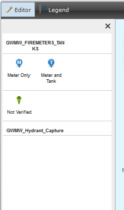
I then published the map to the basic viewer web application. When I open the app I can edit features from both layer but cannot add new features for the second layer. The edit legend only shows one of the services.
[ATTACH=CONFIG]31167[/ATTACH]
Any advice? I have checked, republished and tried a view other things.
Regards
I have a similar problem to cityofgreenriver
I have 2 feature services in a map. They both have the same edit settings.
[ATTACH=CONFIG]31165[/ATTACH]
If I try to edit them in the default ArcGIS online map viewer. It works fine, you can create edit and delete.
[ATTACH=CONFIG]31166[/ATTACH]
I then published the map to the basic viewer web application. When I open the app I can edit features from both layer but cannot add new features for the second layer. The edit legend only shows one of the services.
[ATTACH=CONFIG]31167[/ATTACH]
Any advice? I have checked, republished and tried a view other things.
Regards
by
Anonymous User
Not applicable
04-07-2014
01:28 PM
- Mark as New
- Bookmark
- Subscribe
- Mute
- Subscribe to RSS Feed
- Permalink
- Report Inappropriate Content
We are having the exact same issue with our web service. The attribute information can be edited but when we go to the edit screen in ArcGIS Online even though the layer is there we cannot add data/move data. Was there any head way made on this issue?
04-07-2014
02:20 PM
- Mark as New
- Bookmark
- Subscribe
- Mute
- Subscribe to RSS Feed
- Permalink
- Report Inappropriate Content
Hi
I solved my problem by going back to my mxd. Redoing my categories for my difrrent symbols and publishing it back to ArcGIS online.
Hope it helps.
Regards
I solved my problem by going back to my mxd. Redoing my categories for my difrrent symbols and publishing it back to ArcGIS online.
Hope it helps.
Regards