- Home
- :
- All Communities
- :
- Products
- :
- ArcGIS Pro
- :
- ArcGIS Pro Ideas
- :
- Create tabular labels with multiple attribute fiel...
- Subscribe to RSS Feed
- Mark as New
- Mark as Read
- Bookmark
- Follow this Idea
- Printer Friendly Page
- Report Inappropriate Content
Create tabular labels with multiple attribute fields
- Mark as New
- Bookmark
- Subscribe
- Mute
- Subscribe to RSS Feed
- Permalink
- Report Inappropriate Content
These should provide the following options when choosing the feature class attribute fields to use for the tables:
- Transpose tables (fields across left instead of top)
- Calculated fields - expressions using other field attribute values
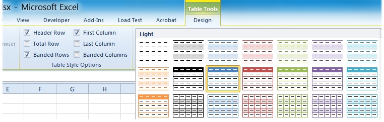
- Formatting similar to those available in Excel for tables including cell shading, borders. Each field used would be assigned a style gallery item so the header cells or total columns could be easily configured. There could be a new Table Labels style class that saves this configuration of all the styles similar to the legend styles. The Table Styles under the Excel 2010 ribbon would be a good thing to follow, where you can easily set the 'Table Style Options' such as Header Row, Banded Rows, Total Row, etc.
- Support automatic creation and styling of row and column totals
- Allow for what would otherwise be multiple tables with just 1 label per feature to be grouped so if there are multiple dates in the feature class for example, you'll get multiple rows in your table, i.e. define a row grouping field
- Support converting these labels to annotation via ArcMap UI as well as a geoprocessing tool to convert the labels to annotation, but that's really another new request
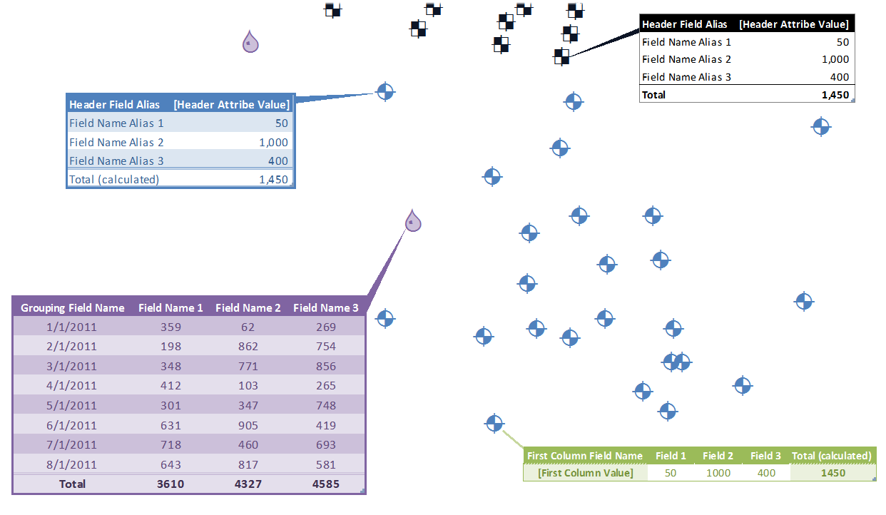
*Each label here would actually be coming from a different feature class, so for each feature class, all the tables would look the same of course.
- « Previous
-
- 1
- 2
- 3
- Next »
- Mark as Read
- Mark as New
- Bookmark
- Permalink
- Report Inappropriate Content
Thanks!
- Mark as Read
- Mark as New
- Bookmark
- Permalink
- Report Inappropriate Content
Anyone come across any decent work-arounds that can be automated? (i.e. please... no more manual excel insertion)
- Mark as Read
- Mark as New
- Bookmark
- Permalink
- Report Inappropriate Content
- Mark as Read
- Mark as New
- Bookmark
- Permalink
- Report Inappropriate Content
- Mark as Read
- Mark as New
- Bookmark
- Permalink
- Report Inappropriate Content
http://planet.qgis.org/planet/tag/2.0/
- Mark as Read
- Mark as New
- Bookmark
- Permalink
- Report Inappropriate Content
I have an ArcMap plugin that creates tables via Excel Interop and pastes the formatted tables as images into ArcMap, but they're images and don't have a leaderline. If I were to create fully customizable tables with leaderlines, that would be amazing.
- Mark as Read
- Mark as New
- Bookmark
- Permalink
- Report Inappropriate Content
- Mark as Read
- Mark as New
- Bookmark
- Permalink
- Report Inappropriate Content
This would be super valuable and amazing!
- Mark as Read
- Mark as New
- Bookmark
- Permalink
- Report Inappropriate Content
Thank you for the comment @KevinBrown10 I took a look and it doesn't appear that you added your kudos to the idea (maybe you have in the past, but I didn't see one recently). While comments are important, kudos (the number of votes) that an idea receives is one of the primary pieces of data that we use to determine traction and trends as we monitor idea activity over time.
Please see https://community.esri.com/t5/custom/page/page-id/arcgis-ideas for a high level overview of how ArcGIS Ideas works. For more details, see Frequently Asked Questions about ArcGIS Ideas
Thank you for your participation in the community and for helping us prioritize future development efforts for ArcGIS Pro.
You must be a registered user to add a comment. If you've already registered, sign in. Otherwise, register and sign in.