- Home
- :
- All Communities
- :
- Products
- :
- ArcGIS Pro
- :
- ArcGIS Pro Questions
- :
- Is it possible to treat unique symbology values li...
- Subscribe to RSS Feed
- Mark Topic as New
- Mark Topic as Read
- Float this Topic for Current User
- Bookmark
- Subscribe
- Mute
- Printer Friendly Page
Is it possible to treat unique symbology values like layers in ArcGIS Pro?
- Mark as New
- Bookmark
- Subscribe
- Mute
- Subscribe to RSS Feed
- Permalink
- Report Inappropriate Content
I am creating a map in ArcGIS Pro for my office, and I was wondering if there was a way to turn the unique values on/off, like layers?
I am using a coded domain to break a single feature class into 8 different symbols, and I want to be able to allow people to only see whichever coded domain that they want, so it doesn't look cluttered.
Is this possible, or would it be better to use 8 separate feature classes for this? There won't be any relationships, joins, or anything else besides just viewing the points.
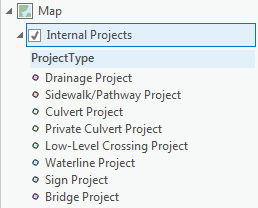
I will include an example of my data:
- Mark as New
- Bookmark
- Subscribe
- Mute
- Subscribe to RSS Feed
- Permalink
- Report Inappropriate Content
Hi,
one option can be to use a definition query and create a statement that shows only the categories you want:
(rx click on the layer> properties> definition query)
Display a subset of features in a layer—ArcGIS Pro | ArcGIS Desktop
- Mark as New
- Bookmark
- Subscribe
- Mute
- Subscribe to RSS Feed
- Permalink
- Report Inappropriate Content
That sort of solves the problem, but I also want to publish the map on our Portal, so that non-GIS people can turn the subsets of the feature class on and off.
If it's not possible to do that, then should I separate them into their own feature classes?
- Mark as New
- Bookmark
- Subscribe
- Mute
- Subscribe to RSS Feed
- Permalink
- Report Inappropriate Content
You can create copies of your layer each of them with a definition query based on what you need to be shown and then publish the service.
Then you can create a map by publishing these layers and allow you customer to switch them on and off.
The advantage is that the source layer is always the same, as you duplicate the layer and not the feature, so if you need to update with new data you will update that one and not the others.
let's say you have your "building" feature
make 3 copies:
1: Commercial building (def. query: type = 'Commercial')
2: Residential buildings (def.query: type = 'Residential')
3: ....