- Home
- :
- All Communities
- :
- Products
- :
- ArcGIS Pro
- :
- ArcGIS Pro Questions
- :
- Is there a Find Route Tool in ArcGIS Pro like the ...
- Subscribe to RSS Feed
- Mark Topic as New
- Mark Topic as Read
- Float this Topic for Current User
- Bookmark
- Subscribe
- Mute
- Printer Friendly Page
Is there a Find Route Tool in ArcGIS Pro like the one in ArcMap?
- Mark as New
- Bookmark
- Subscribe
- Mute
- Subscribe to RSS Feed
- Permalink
- Report Inappropriate Content
In ArcMap there is a GUI Find Route Tool on the Tools Menu. It opens a wizard that lets the user enter stops and barriers interactively.
Has this been implemented in ArcGIS Pro, yet?
If not, when does esri plan to implement it?
Here's what the button looks like.
Here's the wizard window that it opens and a route.

- Mark as New
- Bookmark
- Subscribe
- Mute
- Subscribe to RSS Feed
- Permalink
- Report Inappropriate Content
Is it this? Find Routes (Ready To Use)—ArcGIS Pro | Documentation
- Mark as New
- Bookmark
- Subscribe
- Mute
- Subscribe to RSS Feed
- Permalink
- Report Inappropriate Content
No. I'm looking for the GUI tool, like ArcMap has. See the screenshots above.
Thanks for trying. Let me know if you can find a GUI tool for this in ArcGIS Pro.
I'll amend the question to further clarify this.
- Mark as New
- Bookmark
- Subscribe
- Mute
- Subscribe to RSS Feed
- Permalink
- Report Inappropriate Content
It is different, yet the same.
You might want to have a look at the tutorials, particularly at the images in them.
Network Analyst tutorials—ArcGIS Pro | Documentation
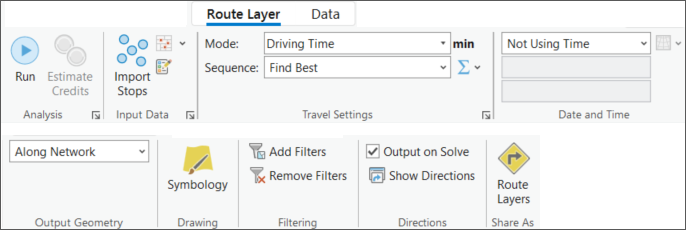
For instance, this example shows the layout of the options available for this case example.
Find the shortest path and generate directions with Route—ArcGIS Pro | Documentation
If you are trying to see if a particular tool icon exists, you can examine the folder in your arcgis pro installation path
C:\Your_Install_Path_\Resources\ArcToolBox\Images and some in
C:\Your_Install_Path_\Resources\ArcToolBox\Toolboxes
If you are looking for a 1:1 replica, that would probably leave an ArcGIS Ideas look or perhaps a suggestion.
... sort of retired...
- Mark as New
- Bookmark
- Subscribe
- Mute
- Subscribe to RSS Feed
- Permalink
- Report Inappropriate Content
Different, convoluted, not as user friendly and, ultimately, misses the point of the wizard feature that is in ArcMap. And, yet, I think I see why they did some of the things they did, and it has a couple of new features, so, it's a start.
Thank you, Dan Patterson, for your helpful reply pointing me toward the information above. I have explored the method described there. It looks like that is what ESRI wants users to accept as a replacement for ArcMap's Find Route wizard. However, Pro falls short of the user friendly ergonomics of the ArcMap wizard. Now, I've been using ESRI since the mid-90's with ArcINFO 7 and all of the software since. I can handle complicated. That's not the issue here. What ESRI is replacing is ArcMap's easy-to-use wizard that worked well, an easy-button, and replaced it with something that is functional, but not an easy-button, at all.
First, let's look at ArcMap.
- With the Find Route wizard, as soon as a user has a network dataset, they can start the wizard, set the Routing Service and preferences and begin.
- To find a route, all a user has to do is select the Add Stops button and select two or more points on a map, which are easy to reorder, and then select Find Route.
- Barriers are equally easy to add.
- The wizard calculates and displays the route labels and automatically displays the turn list along with a selection of helpful buttons to zoom to the extent of the route or a single segment with the click of a single button, etc.
- If the user selects a turn or segment on the list, then that is automatically highlighted on the map. If a user double-clicks on a turn or segment then the map automatically zooms to that segment on the map.
- And after that, when the user quits the wizard, none of the stops or barriers are stored anywhere by default, unless the user specifically wants it. There's no unneeded data management.
Now, let's look at ArcGIS Pro.
- Starting with a network dataset, when we select Network Analysis then Pro automatically creates a cluttering collection of feature classes in a feature dataset in the ever-present default geodatabase. This persists after the routing session and must be deleted if the user doesn't want it hanging around cluttering up their environment. So right at the start Pro creates extra overhead and work for the user.
- Next, to create the stops, rather than having a convenient button, the user must go through the process of starting an Edit session, and then select select Create, select Stops from the Create Features sidebar and only then start adding the actual stops.
- The stops are not labelled with the address as with ArcMap, aside from a number.
- After all of that the user can select the Run button, which is about the only straightforward step in the process.
- Barriers likewise involve editing one of three barrier layers, so it more convoluted than the simple barrier entry process in ArcMap. On the other hand, you can enter three types of barriers, point, line and polygon, instead of just points as in ArcMap, and so is more flexible in this regard.
- To reorder the stops, rather than having a stops list already displayed and conveniently reordered, the user must apparently open and edit the Stops table and change the number in the Sequence field.
- The user can select the Show Directions button to display the turns and route segments list. This is also pretty good and does the things that are in the ArcMap wizard, although it doesn't have dedicated buttons for zooming to the whole route extent or a segment.
- Selecting the word Route above the list zooms to the full extent of the route. This is actually kind of awkward because doing this also expands/contracts the list and you may not want to do that. ESRI should remove the expand/contract behavior from this because the users can do that with the carrot on the left.
- Hovering the pointer over an item highlights a point on a map.
- Selecting an item pans to that point.
- Double-clicking on an item zooms to that point or its route segment, although it does not highlight the segment like ArcMap does.
- After the routing session the user must delete the routing datasets, if they're not wanted.
So, why all of the changes?
Why not a convenient wizard like ArcMap?
While wondering if I could export my stops and barriers lists from the ArcMap wizard list I found that it is not possible and that there have been conversations online about this. The ArcMap wizard will save those lists but cannot export them to another format. I suspect that the Pro developers decided to kill two birds with one stone by just storing these features in a GDB from the outset. This, by its nature, puts those lists in a standard geodatabase format that can be easily exported to any other format, but makes things much more convoluted for the user.
Recommendations to achieve ArcMap Equivalency:
- Is it possible to create a mode that makes saving all of the routing layers optional, so that the user doesn't have to manage this data afterward?
- Simplify the stops and barriers entry.
- Label the stops with the geocoded addresses like in ArcMap.
- Highlight the route segments when they are selected from the Directions list.
- Remove the expand/contract behavior when the user selects Route to view the whole route or add a dedicated button to zoom to the whole route.