- Home
- :
- All Communities
- :
- Products
- :
- ArcGIS Pro
- :
- ArcGIS Pro Questions
- :
- Re: Map Series Extent
- Subscribe to RSS Feed
- Mark Topic as New
- Mark Topic as Read
- Float this Topic for Current User
- Bookmark
- Subscribe
- Mute
- Printer Friendly Page
- Mark as New
- Bookmark
- Subscribe
- Mute
- Subscribe to RSS Feed
- Permalink
- Report Inappropriate Content
Similar to another question I have asked.
How to preserve the extent of a map series. I want to show my full region at the same extent for each iteration of parcels (each page) but the region keeps hopping around. Manually adjusting does not affect anything, it defaults to the original extent of that page.
Solved! Go to Solution.
- Mark as New
- Bookmark
- Subscribe
- Mute
- Subscribe to RSS Feed
- Permalink
- Report Inappropriate Content
Tough more time-consuming, a manual process tends to be easier to hand off to other staff who may not understand the python script.
Here in Kendall County, we have change records that generate automatically whenever changes are made to the cadastre. Along the right side of the map are three inset locators. The township locator has a truly fixed extent with a changing selection, while the section and quarter-section locators have changing extents based on an intersection.
We do a similar process for our tax maps, too.
I'd be happy to send along the python scripts and notebook we use to do these, if that might help you.
Kendall County GIS
- Mark as New
- Bookmark
- Subscribe
- Mute
- Subscribe to RSS Feed
- Permalink
- Report Inappropriate Content
Not sure if this is how you did it; I got it to work using a normal map series without ArcPy.mp (but I 100% got the idea from your solution description). I basically just switched the roles of the 'main map' and 'inset map' and dragged the 'main map' that is the source for the map series outside the layout area so it won't export in my PDFs.
What would normally be the inset map for say a regional overview showing where your series index item is now becomes the main map with a fixed scale set to your region bounding polygon and you change your index feature in this map by having a separate layer in its map frame that will have a page query to match the name of the map series page.
Not sure if this will help the issue of needing to add new layers and symbology for your specific workflow, or if you can now preset it using this so non-GIS savvy users can just jump in and change index pages. It should, though, help bypass any fear of Python/programming non-savvy people have (if they have to try and use your code too) and make it a little easier to go through the process using Pro's standard UI.
- Mark as New
- Bookmark
- Subscribe
- Mute
- Subscribe to RSS Feed
- Permalink
- Report Inappropriate Content
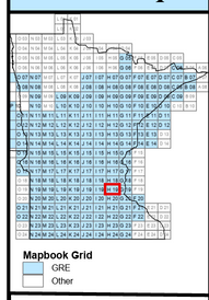
Are you talking about a reference map that shows the full extent of your system and where the current map page is centered on?
Like the inset above?
To do this Insert a New Map Frame into your Layout. Add to it the features you want in the inset. Now this map series spans Minnesota, Wisconsin, North Dakota and South Dakota So to the Inset I add the state boundary as well.
Then in the Display Options (second properties tab)
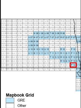
The constraint is the Map Series Polygons that will be circled in red and the State Boundary that the map series polygon fits in will be centered in the window.
I the image below I selected a North Dakota grid and it swapped the Inset to North Dakota
- Mark as New
- Bookmark
- Subscribe
- Mute
- Subscribe to RSS Feed
- Permalink
- Report Inappropriate Content
Thanks, Robert! No python needed, folks. Not sure why this isn't flagged as the answer. Major kudos! Learn somethin' new every day 🙂
Just go into the Layout properties of your inset map (or in my case, a side panel map) and set the Display Constraint to "Fixed extent." I didn't have to specify a layer. I merely adjusted the map extent to where I wanted it beforehand, and then set the constraint afterwards.
Now, when the map series changes, the map doesn't move, but different features appear based on an attribute (forgot to mention, I also have a Page Query defined for the specific layer in the map that I want to display dynamically, based on the map series -- see below).
Set a Page Query on your layer and indicate what attribute needs to match the map series in order to be displayed.
Hope this helps someone!
- Mark as New
- Bookmark
- Subscribe
- Mute
- Subscribe to RSS Feed
- Permalink
- Report Inappropriate Content
Unfortunately, the Display Constraint "Fixed extent." is not shown, only "Map series"...
- Mark as New
- Bookmark
- Subscribe
- Mute
- Subscribe to RSS Feed
- Permalink
- Report Inappropriate Content
I have come across the same problem. My quick solution without ArcPy is to create two map frames, one is the map series that zooms into the specific feature and another map frame which has the specific feature highlighted on the map but with a static zoom (so an indicator/overview map). Then I have moved the main map series off my layout so it is not seen in the final printed layout and used the indicator map as my main map in my layout.
- Mark as New
- Bookmark
- Subscribe
- Mute
- Subscribe to RSS Feed
- Permalink
- Report Inappropriate Content
We're trying this workaround out, thanks! Also FYI, I posted a new idea and referenced this thread as part of it. This seems like something that would be super useful as a simple, fourth option when setting up a map series so we could specify a fixed scale AND extent.
- Mark as New
- Bookmark
- Subscribe
- Mute
- Subscribe to RSS Feed
- Permalink
- Report Inappropriate Content
Easy way to solve this. With the Layout activated, create a new feature class (Feature Class A) that includes the attribute INDEX. Create as a rectangle to full extent of your layout frame. Then copy/paste the same rectangle to match the number of records in Feature Class B. Give each of these rectangles INDEX a name that matches Feature Class B INDEX name. Then make the map series for the mapbook at the fixed scale and center. Then you go into the properties of the feature class you actually want displayed and add in a Page Query to match the attribute as the mapbook. This keeps the extent consistent while toggling through the data you want to highlight.
- « Previous
-
- 1
- 2
- Next »
- « Previous
-
- 1
- 2
- Next »


