- Home
- :
- All Communities
- :
- Products
- :
- ArcGIS Pro
- :
- ArcGIS Pro Questions
- :
- Rasters won't display after being added to mosaic ...
- Subscribe to RSS Feed
- Mark Topic as New
- Mark Topic as Read
- Float this Topic for Current User
- Bookmark
- Subscribe
- Mute
- Printer Friendly Page
Rasters won't display after being added to mosaic dataset
- Mark as New
- Bookmark
- Subscribe
- Mute
- Subscribe to RSS Feed
- Permalink
- Report Inappropriate Content
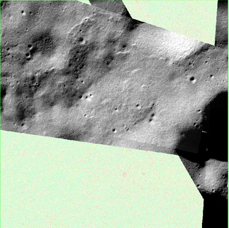
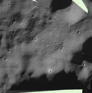
I am attempting to mosaic 12 rasters. All rasters have been exported to the geodatabase as .tif . After creating the mosaic dataset, I attempt to add all 12 rasters. The process is completed quickly, but only 6 of the rasters are displaying in the mosaic dataset.
Here is a screenshot of how the mosaic dataset displays:
This is how all the images SHOULD display:
The other images do not render at higher or lower scales. All 12 images appear in the "footprint" attribute table. Overviews, stats and pyramids have also been built duing the "Add Raster to Mosaic Dataset" process.
Any idea on what's going on here?
Solved! Go to Solution.
Accepted Solutions
- Mark as New
- Bookmark
- Subscribe
- Mute
- Subscribe to RSS Feed
- Permalink
- Report Inappropriate Content
I was able to have all raster's displayed after calculating the correct MaxPS (in attribute table) for the rasters that were not displaying. Once calculated, I overwrote the original MaxPS values that were in the attribute table.
More info here: https://resources.arcgis.com/en/help/main/10.2/index.html#/Cell_size_ranges_in_a_mosaic_dataset/009t...
Honestly, as a short cut, I probably could have gotten away with just choosing one of the other MaxPS for one of the other displayed images.
Hope this helps.
- Mark as New
- Bookmark
- Subscribe
- Mute
- Subscribe to RSS Feed
- Permalink
- Report Inappropriate Content
Hi,
It is possible that the missing rasters have invalid or incomplete metadata, or that they are not properly aligned with the mosaic dataset. You can try to check the metadata of the missing rasters and ensure they are in the same coordinate system and have the same cell size as the mosaic dataset. Additionally, you can try to adjust the mosaic method and blending options in the mosaic dataset properties to improve the display of the rasters.
I hope this helps
Omar
- Mark as New
- Bookmark
- Subscribe
- Mute
- Subscribe to RSS Feed
- Permalink
- Report Inappropriate Content
Try setting Pro to auto create statistics and pyramids then manually add your 12 images to see if it complains about anything, offers to update/create/re-create etc.
Then exit Pro and repeat to verify if they look and act any better after doing that?
- Mark as New
- Bookmark
- Subscribe
- Mute
- Subscribe to RSS Feed
- Permalink
- Report Inappropriate Content
Does your mosaic have overviews? Zoom in and see if the rasters appear at a very small scale. If they do, then you probably just have overviews that were generated prior to the new rasters being added.
Kendall County GIS
- Mark as New
- Bookmark
- Subscribe
- Mute
- Subscribe to RSS Feed
- Permalink
- Report Inappropriate Content
i zoomed in to 1:750 and one of the rasters displayed. What would you suggest I do to overwrite the overviews?
- Mark as New
- Bookmark
- Subscribe
- Mute
- Subscribe to RSS Feed
- Permalink
- Report Inappropriate Content
Been a while since I worked with mosaics, but you should be able to use the Build Overviews tool and specify that you want all overviews generated and overwrite the existing ones.
Kendall County GIS
- Mark as New
- Bookmark
- Subscribe
- Mute
- Subscribe to RSS Feed
- Permalink
- Report Inappropriate Content
Building overviews didn't work for me, but if you're interested in how I was able to solve this issue check the accepted solution. There was something funky going on with the MaxPS in the images that weren't displaying correctly.
- Mark as New
- Bookmark
- Subscribe
- Mute
- Subscribe to RSS Feed
- Permalink
- Report Inappropriate Content
Check your raster resolution. Sometimes rasters won't display at certain resolutions
- Mark as New
- Bookmark
- Subscribe
- Mute
- Subscribe to RSS Feed
- Permalink
- Report Inappropriate Content
I was able to have all raster's displayed after calculating the correct MaxPS (in attribute table) for the rasters that were not displaying. Once calculated, I overwrote the original MaxPS values that were in the attribute table.
More info here: https://resources.arcgis.com/en/help/main/10.2/index.html#/Cell_size_ranges_in_a_mosaic_dataset/009t...
Honestly, as a short cut, I probably could have gotten away with just choosing one of the other MaxPS for one of the other displayed images.
Hope this helps.

