- Home
- :
- All Communities
- :
- Products
- :
- ArcGIS Pro
- :
- ArcGIS Pro Questions
- :
- Re: Several years ago Margaret Maher published a g...
- Subscribe to RSS Feed
- Mark Topic as New
- Mark Topic as Read
- Float this Topic for Current User
- Bookmark
- Subscribe
- Mute
- Printer Friendly Page
Several years ago Margaret Maher published a great reference for lining up data in ArcGIS. My question is there any guidance on creating a projection file for ACAD polylines (dwg) for ArcGIS Pro 2.2?
- Mark as New
- Bookmark
- Subscribe
- Mute
- Subscribe to RSS Feed
- Permalink
- Report Inappropriate Content
Is there any guidance on creating a projection file for ACAD polylines (dwg) for ArcGIS Pro 2.2? I can use Desktop 6.1 but sure would like to use Pro as I am trying to convert, best as possible.
- Mark as New
- Bookmark
- Subscribe
- Mute
- Subscribe to RSS Feed
- Permalink
- Report Inappropriate Content
do you mean a 'world file' ?
- Mark as New
- Bookmark
- Subscribe
- Mute
- Subscribe to RSS Feed
- Permalink
- Report Inappropriate Content
Thanks for the information Dan. Unfortunately world file is not the answer. Engineers/Surveyors in this area are notorious for developing ACAD mapping for water/wastewater infrastructure that has no known coordinate system. They use their own x,y,z. Often they do not even use the same coordinates for similar projects in the same area and seldom will the data land on a map anywhere. As you can see from the inserted image below the ACAD is scaled and projected way out of the world mapping area which is depicted at the lower left corner. Margaret developed a process that will align the data with any known projected data and create a projection file that can be saved in coordinate favorites and used for all engineering mapping that utilize the same x,y information when developing their drawings. Like I mentioned above, I can do this in ArcGIS for Desktop but have failed to find a procedure that will work in Pro. In Desktop it takes several attempts of scaling and aligning and never ends up perfect but is more than sufficient for mapping infrastructure.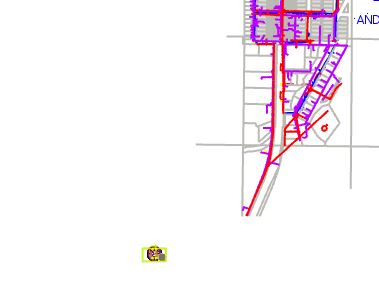
- Mark as New
- Bookmark
- Subscribe
- Mute
- Subscribe to RSS Feed
- Permalink
- Report Inappropriate Content
Spatial adjustment... like image georeferencing, but for vector data...
About spatial adjustment—Help | ArcGIS Desktop
and see all the links underneath it as they pertain to the same topic
conflation tools in PRO
An overview of the Conflation toolset—Help | ArcGIS Desktop
I am sure there are similar links
- Mark as New
- Bookmark
- Subscribe
- Mute
- Subscribe to RSS Feed
- Permalink
- Report Inappropriate Content
Hi Dan. So I have re-read all of the guidance from the link you supplied. I missed some of the steps when I first reviewed. I am going to give it a whirl and see what happens. Thanks.
- Mark as New
- Bookmark
- Subscribe
- Mute
- Subscribe to RSS Feed
- Permalink
- Report Inappropriate Content
The third edition of "Lining Up Data in ArcGIS: a guide to map projections" was released by Esri Press on June 28 2018. The new edition includes a chapter on applying and transforming vertical coordinate systems, as well as the opportunity to download the data used to create the screenshots for the exercises outlined in the book. Our original intention was to include information about how to create custom projection files in Pro to align CAD data, but the tools used in ArcMap to calculate parameters and create the custom projections is not available yet in Pro. That functionality will be available in future releases.
As Dan Patterson mentioned, there is the option of georeferencing CAD data, both in ArcMap, and in Pro, using a World File. The issue I have with georeferencing is that with 2 control points, the data's shape is being changed - lengths of lines are changing, as are the angles between the lines, so if the CAD file represents survey-grade data, the georeferenced data no longer represents the survey measures acquired in the field.
On the other hand, creating a custom projection file simply moves the data to a new location on the screen, without making any changes to the shape of the data. Once that data has the custom projection defined, and is imported into a geodatabase, the feature dataset can then be projected to a standard coordinate system like StatePlane, and added to an existing parcel fabric for example, preserving the accuracy of the original survey.
- Mark as New
- Bookmark
- Subscribe
- Mute
- Subscribe to RSS Feed
- Permalink
- Report Inappropriate Content
Thanks Margaret! I have spent the last few hours following the guidelines in Pro Help on CAD as referenced by Dan. You are correct in saying that the survey grade data becomes "jacked up" for the lengths, etc. Nothing I rendered was acceptable for the infrastructure mapping. I believe at this time my best option is to utilize the projection file creation process as per your publication guidance. I am doing my best not to revert back to Desktop but seem to be going that direction quite often. Pro is great. Love the interface with AGOL, but can be frustrating when going back and forth just to move a project along. Sigh...….. Lots to learn.
- Mark as New
- Bookmark
- Subscribe
- Mute
- Subscribe to RSS Feed
- Permalink
- Report Inappropriate Content
I agree that jumping back and forth between the two programs can be frustrating. The interface with AGOL in Pro is amazing, but the program has a way to go before it will handle the pure GIS issues the way ArcMap does. Of course the age difference between the programs is huge - ArcGIS Desktop was first conceived in the mid-1990's, so it is a mature program. By comparison, ArcGIS Pro is just a baby - a very promising child, but has a ways to go. Another thing in Pro that is fantastic is that is used Esri's own custom Graphic Data Interface (GDI) for printing and exporting. The Microsoft GDI used in ArcMap is very limiting, and there were a lot of issues. If printing or exporting to PDF in ArcMap are a problem for you, I suggest importing your map into Pro, and doing the print/export process from there.
Based on your screenshots above, your CAD data was created in inches, millimeters, or some other custom units. To save yourself frustration, don't try to align the CAD data with anything in Web Mercator meters. The distortion in that coordinate system is simply to great. For the US, StatePlane generally works very well. If you need further assistance with that issue, have a case created with support, and I'll take it.