- Home
- :
- All Communities
- :
- Products
- :
- ArcGIS Pro
- :
- ArcGIS Pro Questions
- :
- Trying to find coordinates in map view
- Subscribe to RSS Feed
- Mark Topic as New
- Mark Topic as Read
- Float this Topic for Current User
- Bookmark
- Subscribe
- Mute
- Printer Friendly Page
- Mark as New
- Bookmark
- Subscribe
- Mute
- Subscribe to RSS Feed
- Permalink
- Report Inappropriate Content
ArcMap's Identify tool is really useful for clicking on a map view, then providing the coordinates for the point being queried under the Location window on the Identify tool pop-up. For me, it is really easy and useful tool for assisting with the georeferencing of localities by first finding them in ArcMap, then copying the locality information and pasting it into a database.

I am unable to find any similar tool for doing the same in AcrGIS Pro 1.2. Am I missing something?
The Measure features tool under the Inquiry menu comes close but only selects features and does not provide coordinates. I am hoping there is a tool that provides coordinates by simply clicking somewhere on a map.
I really hope I am just not seeing it .....?
Cheers
Mervyn
Solved! Go to Solution.
Accepted Solutions
- Mark as New
- Bookmark
- Subscribe
- Mute
- Subscribe to RSS Feed
- Permalink
- Report Inappropriate Content
Check out the Coordinate Conversion Addin (.NET). It is put out by one of the Esri teams on GitHub. It has a version for ArcMap and ArcGIS Pro. It doesn't integrate into the Explore tool like you would like, but it does provide a quick way to get coordinates of screen cursors/locations and even have them in multiple formats.
- Mark as New
- Bookmark
- Subscribe
- Mute
- Subscribe to RSS Feed
- Permalink
- Report Inappropriate Content
Explore tool
quote... Contains functionality of Pan, Zoom, and other navigation tools, and HTML Pop-Up and Identify tools
Navigation—ArcGIS Pro | ArcGIS for Desktop then you can do stuff extra
- Mark as New
- Bookmark
- Subscribe
- Mute
- Subscribe to RSS Feed
- Permalink
- Report Inappropriate Content
Hi Dan
Thank you for the links and taking the time to reply. You really are quite
extraordinary in the kind manner if which you so freely and
enthusiastically help all of us struggling to master Pro (and other Esri
products). Thank you!
Back to my problem at hand, I did explore your links and the Explore tool's
functionality but I still cant find any way of extracting the coordinates
for a point when I click on a map. The pop-up window would be where I would
expect it and I hope it can be integrated into this window at some point.
To me it seems very useful to know the exact coordinates for a point
queried.
Judging from the response to my query, I gather that it is currently not
possible to extract the coordinates as hoped.
Best wishes,
Mervyn
- Mark as New
- Bookmark
- Subscribe
- Mute
- Subscribe to RSS Feed
- Permalink
- Report Inappropriate Content


some fresh images... I have been kindof behind in the images.
ArcGIS Pro ... useful transitioning links and images Some potentially useful stuff, I am putting together.
The coordinates for these are projected coordinates btw and I just selected a point on screen to return the topmost layer as an example


- Mark as New
- Bookmark
- Subscribe
- Mute
- Subscribe to RSS Feed
- Permalink
- Report Inappropriate Content
Hi Mervyn,
Have you tried right clicking an selecting "What's Here?" This will bring up x/y coordinate locations for you (similar to Google Maps behavior).
- Mark as New
- Bookmark
- Subscribe
- Mute
- Subscribe to RSS Feed
- Permalink
- Report Inappropriate Content
Dear Dan and Adrian
Thanks for the advice and comments.
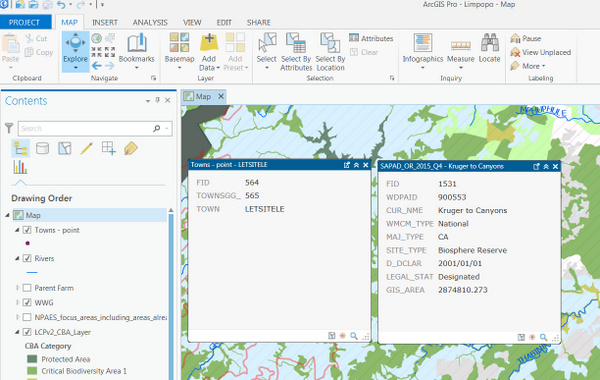
Dan, from what I can gather is that the coordinates you see in your screen shot are actually from the attribute table of the point feature being queried. This is the behavior that I observe (see below screenshot - clicking on polygon and point features). Using this approach for determining coordinates would require that one can only query known point features which have the coordinates in the attribute table.
Adrian, the " What's here?" tool is dependent on the use the ESRI World Geocoder service (and any other locate providers added under settings) to highlight the points of interest and coordinates of the features close to where one is clicking on the map. This approach could work well in urban environments where there are many points of interest available. Disabling the geocoder in the locator settings results in no features being returned and no pop-up windows with coordinates opened.
My current area of interest is Mozambique and the data is seemingly much more sparse as very few records are returned when trying the What's here? tool. I have added several of my larger feature layers with a good coverage to the Locate tool using the Create Address Locator geoprocessing tool, such as rivers and a gazetteer for Mozambique, hence I am able to get some success when there are features close by.
To Dan and Adrian, thank you for the two suggestions but neither can fully provide the functionality that was available in ArcMap. I will try and add as a suggestion to the ArcGIS Ideas site once I can login to the site (I have never been successful in doing so). Luckily I see the Ideas site is migrating to Geonet.
- Mark as New
- Bookmark
- Subscribe
- Mute
- Subscribe to RSS Feed
- Permalink
- Report Inappropriate Content
I think it would be a great addition to the Ideas site. I will watch for it!
- Mark as New
- Bookmark
- Subscribe
- Mute
- Subscribe to RSS Feed
- Permalink
- Report Inappropriate Content
Check out the Coordinate Conversion Addin (.NET). It is put out by one of the Esri teams on GitHub. It has a version for ArcMap and ArcGIS Pro. It doesn't integrate into the Explore tool like you would like, but it does provide a quick way to get coordinates of screen cursors/locations and even have them in multiple formats.
- Mark as New
- Bookmark
- Subscribe
- Mute
- Subscribe to RSS Feed
- Permalink
- Report Inappropriate Content
Hi Joshua
This add-in works like charm! Thank you.
Regards